Amsterdam is the capital and most populous city of the Netherlands with a population of 872,680 within the city proper, 1,380,872 in the urban area and 2,410,960 in the metropolitan area. Found within the province of North Holland, Amsterdam is colloquially referred to as the "Venice of the North", attributed by the large number of canals which form a UNESCO World Heritage Site.

Dam Square or Dam is a town square in Amsterdam, the capital of the Netherlands. Its notable buildings and frequent events make it one of the most well-known and important locations in the city and the country.

The Amstel is a river in the south of the province of North Holland in the Netherlands. The river flows from the Aarkanaal in Nieuwveen northwards to the IJ in Amsterdam. The city of Amsterdam took its name from the river.

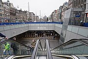
The Damrak is an avenue and partially filled in canal at the centre of Amsterdam, running between Amsterdam Centraal in the north and Dam Square in the south. It is the main street where people arriving at the station enter the centre of Amsterdam. Also it is one of the two GVB tram routes from the station into the centre, with lines 4, 9, 16, and 25 running down it. It is also on the route of the North/South Line being constructed between the existing metro station at Centraal Station and the new Rokin station.

The Singel is one of the canals of Amsterdam. The Singel encircled Amsterdam in the Middle Ages, serving as a moat around the city until 1585, when Amsterdam expanded beyond the Singel. The canal runs from the IJ bay, near the Central Station, to the Muntplein square, where it meets the Amstel river. It is now the inner-most canal in Amsterdam's semicircular ring of canals.
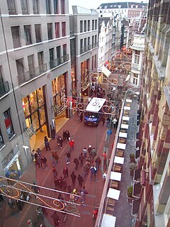
The Kalverstraat is a busy shopping street of Amsterdam, the capital of the Netherlands. The street runs roughly North-South for about 750 meters, from Dam Square to Muntplein square. The Amsterdam Museum is located in a former orphanage between Kalverstraat and Nieuwezijds Voorburgwal.
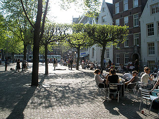
The Spui is a square in the centre of Amsterdam, the capital of the Netherlands. The Spui was originally a body of water that formed the southern limit of the city until the 1420s, when the Singel canal was dug as an outer moat around the city. In 1882 the Spui was filled in and became the square that we know today.

Gerrit A. van Arkel was a Dutch architect who designed many of Amsterdam's most prominent Jugendstil buildings.

The Zwanenburgwal is a canal and street in the center of Amsterdam. During the Dutch Golden Age the canal was home to painter Rembrandt van Rijn, as well as philosopher Spinoza lived here. In 2006 it was voted one of the most beautiful streets in Amsterdam by readers of Het Parool, a local daily newspaper.

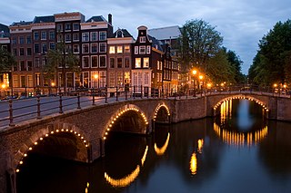
Amsterdam, capital of the Netherlands, has more than one hundred kilometers of grachten (canals), about 90 islands and 1,500 bridges. The three main canals, dug in the 17th century during the Dutch Golden Age, form concentric belts around the city, known as the Grachtengordel. Alongside the main canals are 1550 monumental buildings. The 17th-century canal ring area, including the Prinsengracht, Keizersgracht, Herengracht and Jordaan, were listed as UNESCO World Heritage Site in 2010, contributing to Amsterdam's fame as the "Venice of the North".

The Muntplein is a square in the centre of Amsterdam. The square is in fact a bridge — the widest bridge in Amsterdam — which crosses the Singel canal at the point where it flows into the Amstel river. All bridges in Amsterdam are numbered, and the Muntplein carries the number 1.

The Hollandsche Manege in Amsterdam is the oldest riding school in the Netherlands, dating back to 1744. The current building, inspired by the Spanish Riding School in Vienna, was constructed in 1882. The building has been declared a rijksmonument.

Rivierenbuurt is a neighbourhood of Amsterdam, Netherlands. The neighbourhood is situated in the eastern part of the borough of Amsterdam-Zuid, bordered by the river Amstel to the east, the Boerenwetering canal in the west, the Amstelkanaal in the north and the A10 motorway in the south. In 2013, the Rivierenbuurt had approximately 28,400 residents.

The Korenbeurs was a 17th-century commodity market in Amsterdam where grain was traded. The building stood on the banks of the Amstel, on the western side (Nieuwezijde) of the Damrak. It was directly south of the Oude Brug bridge, on a spot now occupied by the former stock and commodity exchange Beurs van Berlage.
The following is a timeline of the history of the municipality of Amsterdam, Netherlands.

The Nieuwendijk is a major shopping street in central Amsterdam. There are some 200 shops along the street. The street, which dates to the early medieval history of Amsterdam, counts 98 buildings with rijksmonument status.

The Vijzelgracht is a street and former canal in Amsterdam. The Vijzelgracht is adjacent to the Grachtengordel and is an extension of one of the most important city radii for public transport and normal traffic. This through route leads via Vijzelstraat, Rokin, Dam Square and Damrak to Central Station. To the south of Vijzelgracht, the Nieuwe Vijzelstraat connects to Weteringschans.

The Spuistraat in downtown Amsterdam connects the Hekelveld to the Spui. It runs roughly north to south, parallel to the Singel and the Nieuwezijds Voorburgwal. At the Royal Palace of Amsterdam, the Spuistraat crosses the Raadhuisstraat and Paleisstraat. Originally the Spuistraat was a canal, the Nieuwezijds Achterburgwal. The canal was filled in in 1867, and the street renamed then.