GVB is the municipal public transport operator for Amsterdam, the capital of the Netherlands, operating metro, tram, bus and ferry services in the metropolitan area of Amsterdam.
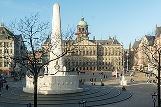
Dam Square or the Dam is a town square in Amsterdam, the capital and most populated city of the Netherlands. Its notable buildings and frequent events make it one of the best-known and most important locations in the city and the country.

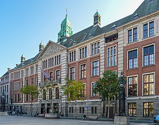
The Beurs van Berlage is a building on the Damrak, in the centre of Amsterdam. It was designed as a commodity exchange by architect Hendrik Petrus Berlage and constructed between 1896 and 1903. It influenced many modernist architects, in particular functionalists and the Amsterdam School. It is now used as a venue for concerts, exhibitions and conferences.
Euronext Amsterdam is a stock exchange based in Amsterdam, the Netherlands. Formerly known as the Amsterdam Stock Exchange, it merged on 22 September 2000 with the Brussels Stock Exchange and the Paris Stock Exchange to form Euronext. The registered office of Euronext, itself incorporated in the Netherlands a public limited company, is also located in the exchange.

Amsterdam Centraal station is the largest railway station in Amsterdam, North Holland, the Netherlands. A major international railway hub, it is used by 192,000 passengers a day, making it the second busiest railway station in the country after Utrecht Centraal and the most visited Rijksmonument of the Netherlands.

The Rotterdam Metro is a rapid transit system operated in Rotterdam, Netherlands and surrounding municipalities by RET. The first line, called Noord – Zuidlijn opened in 1968 and ran from Centraal Station to Zuidplein, crossing the river Nieuwe Maas in a tunnel. It was the first metro system to open in the Netherlands. At the time it was also one of the shortest metro lines in the world with a length of only 5.9 km (3.7 mi).
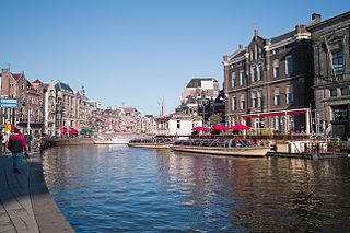
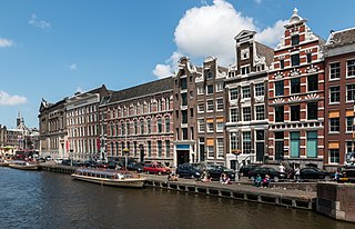
The Rokin is a canal and major street in the centre of Amsterdam. The street runs from Muntplein square to Dam square. The Rokin canal used to run from Muntplein square to Dam Square, but in 1936, the part between Spui square and Dam Square was filled in. Canal boats are now moored on the remaining part of the water, from the Amstel to Grimburgwal.

Rotterdam Centraal station is the main railway station of the city Rotterdam in South Holland, Netherlands. The station received an average of 112,000 passengers daily in 2019. The current station building, located at Station Square, was officially opened in March 2014.

The Ferdinand Bolstraat is a street in Amsterdam, named after the artist Ferdinand Bol in 1872.
Binnenstad is a neighborhood of Amsterdam, Netherlands located in the Centrum borough. It is divided between the Burgwallen Oude Zijde (east) and Burgwallen Nieuwe Zijde (west) areas.
De Pijp is a neighbourhood of Amsterdam, Netherlands. It is located directly south of Amsterdam's city centre and it is part of the borough Amsterdam-Zuid, in a part of the city known as the Old South. It is served by De Pijp metro station. Most streets in De Pijp are named after Dutch painters, like Jan Steen, Frans Hals, Ruysdael and Vincent van Gogh. The three districts composing the area are Oude Pijp, Nieuwe Pijp and Diamantbuurt.
The Jodenbuurt is a neighbourhood of Amsterdam, Netherlands. For centuries before World War II, it was the center of the Dutch Jews of Amsterdam — hence, its name. It is best known as the birthplace of Baruch Spinoza, the home of Rembrandt, and the Jewish ghetto of Nazi occupation of the Netherlands.

Rivierenbuurt is a neighbourhood of Amsterdam, Netherlands. The neighbourhood is situated in the eastern part of the borough of Amsterdam-Zuid, bordered by the river Amstel to the east, the Boerenwetering canal in the west, the Amstelkanaal in the north and the A10 motorway in the south. In 2013, the Rivierenbuurt had approximately 28,400 residents.

The Korenbeurs was a 17th-century commodity market in Amsterdam where grain was traded. The building stood on the banks of the Amstel, on the western side (Nieuwezijde) of the Damrak. It was directly south of the Oude Brug bridge, on a spot now occupied by the former stock and commodity exchange Beurs van Berlage.
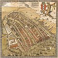
The following is a timeline of the history of the municipality of Amsterdam, Netherlands.
The Geldersekade is a canal and a street in Amsterdam that connects the Nieuwmarkt with the Prins Hendrikkade. The Geldersekade is in the easternmost part of De Wallen, the red light district, and borders Chinatown.

Prins Hendrikkade is a major street in the centre of Amsterdam. It passes Amsterdam Central Station, intersects the Damrak at the mouth of the Amstel river, and forms the southern end of the IJtunnel across the IJ bay. The street formed the northern edge and outer harbour of the city until the 19th century. It was named after Prince Henry of the Netherlands, youngest son of King William II, following Henry's death in 1879.

Metro line 52, also known as the north–south line, is part of the Amsterdam metro network. The line starts in Amsterdam-Noord, continues under Amsterdam-Centrum to its terminus in Amsterdam Zuid station. It has six intermediate stops: Noorderpark, Centraal Station, Rokin, Vijzelgracht, De Pijp en Europaplein. The line was officially opened on 21 July 2018 by the mayor of Amsterdam, Femke Halsema and was opened to the public on the next day, 22 July 2018.