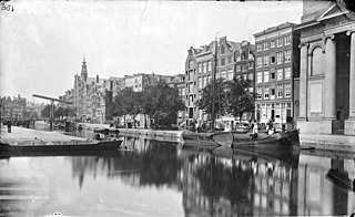
History
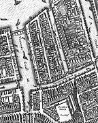
The area between the Kloveniersburgwal and the Zwanenburgwal was still "outside the fortress" (outside the city walls) until the late 16th century. It was added to the city in 1593. At that time there were weaving mills in the area, where after washing, carding, spinning, weaving and dying the woolen fabric was stretched on wooden frames (raamen) to dry and stretch. The names Raamgracht, Ververstraat and Staalstraat recall that period. On a map from 1625 by Balthasar Florisz. van Berckenrode the canal is called the "Verwers Graft" (Dyers Canal). It then makes a right angle near the Moddermeule Steech and merges into a wider area that is also called Verwers Graft (now called Zwanenburgwal).
In the 17th century the cloth weavers moved to the then western border of the city, near the Bloemgracht and the Jordaan. [1] The Raamstraat, Raamplein and Raampoort can still be found there.
The Raamgracht is located in the former Jodenbuurt (Jewish quarter) of Amsterdam. During World War II many Jewish residents of Raamgracht were taken to concentration camps and did not survive the war. [2] Afterwards, part of the buildings on the north side of the Raamgracht was demolished for the construction of the Oostlijn metro line. The Pentagon designed by Theo Bosch was then built here.
Trivia
The weekly Vrij Nederland has been established for many years in a monumental building from 1914 on Raamgracht 4, on the corner with the Kloveniersburgwal. The Weekbladpers (publisher of Vrij Nederland and magazines like Opzij and Hollands Diep) is also located at Raamgracht 4. Journalist Igor Cornelissen wrote the book Raamgracht 4 about his time as editor of Vrij Nederland in the 1960s.
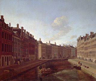
Sal Meijer painted the Raamgracht. This painting was purchased by the government in 1957 on the occasion of its 80th birthday. [3]
In the early 1970s, the poet and writer Hugo Claus, together with his then muse, the actress Sylvia Kristel, occupied the Raamgracht 5-7 building. [4]

The Prinsengracht is a 3.2-kilometer (2.0 mi)-long canal that runs parallel to the Keizersgracht in the center of Amsterdam. The canal, named after the Prince of Orange, is the fourth of the four main canals belonging to the canal belt.

Willem Janszoon Blaeu, also abbreviated to Willem Jansz. Blaeu, was a Dutch cartographer, atlas maker, and publisher. Along with his son Johannes Blaeu, Willem is considered one of the notable figures of the Netherlandish or Dutch school of cartography during its golden age in the 16th and 17th centuries.

The Stopera is a building complex in Amsterdam, Netherlands, housing both the city hall of Amsterdam and the Dutch National Opera and Ballet, the principal opera house in Amsterdam that is home of Dutch National Opera, Dutch National Ballet and Holland Symfonia. The building was designed by Wilhelm Holzbauer and Cees Dam.

Renate Ida Rubinstein was a German-Dutch writer, journalist and columnist.

Meijer Isaac de Haan was a Dutch painter. In French the name was written Meyer de Haan.
The Keizersgracht is a canal in Amsterdam, the Netherlands. It is the second of the three main Amsterdam canals that together form the Grachtengordel, or canal belt, and lies between the inner Herengracht and outer Prinsengracht.
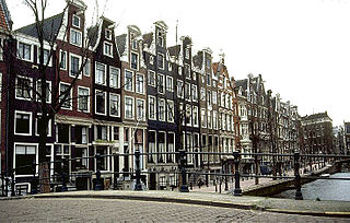
The Herengracht is the second of four Amsterdam canals belonging to the canal belt and lies between the Singel and the Keizersgracht. The Gouden Bocht in particular is known for its large and beautiful canal houses.

Amsterdam, capital of the Netherlands, has more than 100 kilometers (62 mi) of grachten (canals), about 90 islands and 1,500 bridges. The three main canals, dug in the 17th century during the Dutch Golden Age, form concentric belts around the city, known as the Grachtengordel. Alongside the main canals are 1550 monumental buildings. The 17th-century canal ring area, including the Prinsengracht, Keizersgracht, Herengracht and Jordaan, were listed as UNESCO World Heritage Site in 2010, contributing to Amsterdam's fame as the "Venice of the North".

The Grachtengordel, known in English as the Canal District, is a neighborhood in Amsterdam, Netherlands located in the Centrum district. The seventeenth-century canals of Amsterdam, located in the center of Amsterdam, were added to the UNESCO World Heritage List in August 2010. The Amsterdam Canal District consists of the area around the city's four main canals: the Singel, the Herengracht, the Keizersgracht, and the Prinsengracht. From the Brouwersgracht, the canals are generally parallel with one another, leading gradually southeast into the Amstel river.

The Waag is a 15th-century building on Nieuwmarkt square in Amsterdam. It was originally a city gate and part of the walls of Amsterdam. Later it served as a guildhall, museum, fire station and anatomical theatre, among other things.

The Handboogdoelen is a building on the Singel canal in Amsterdam, near Koningsplein square. It dates back to the early 16th century and originally served as headquarters and shooting range of the local schutterij. Most of the current building at Singel 421 dates to the 18th century and is part of the main complex of the Amsterdam University Library. The Doelenzaal hall on the ground floor of the building is used for lectures, meetings, receptions and doctoral dissertations. The building has rijksmonument status.
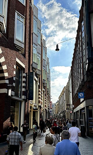
The Nieuwendijk is a major shopping street in central Amsterdam. There are some 200 shops along the street. The street, which dates to the early medieval history of Amsterdam, counts 98 buildings with rijksmonument status.
The Leidsegracht is a canal in Amsterdam, Netherlands. It is a cross-canal in Amsterdam-Center that connects Herengracht, Keizersgracht, Prinsengracht and Lijnbaansgracht and flows into the Singelgracht at Marnixstraat.
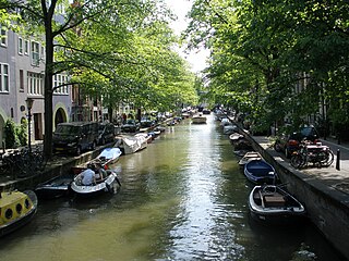
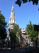
The Groenburgwal is a canal in Amsterdam that connects the Raamgracht with the Amstel. The Groenburgwal is parallel to the Kloveniersburgwal and the Zwanenburgwal, in the shadow of the tower of the Zuiderkerk.

The Oudeschans, or Oude Schans, originally the Nieuwe Gracht, is a wide canal in the eastern part of the inner city of Amsterdam.
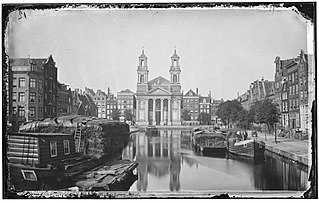
The Leprozengracht was a canal in Amsterdam that defined one side of the Vlooienburg island. Leprozengracht and the connected Houtgracht canal were filled in 1882 to form the Waterlooplein.
The Houtgracht was a canal in Amsterdam that defined one side of Vlooienburg island. Houtgracht and the connected Leprozengracht canal were filled in 1882 to form the Waterlooplein.

The Spuistraat in downtown Amsterdam connects the Hekelveld to the Spui. It runs roughly north to south, parallel to the Singel and the Nieuwezijds Voorburgwal. At the Royal Palace of Amsterdam, the Spuistraat crosses the Raadhuisstraat and Paleisstraat. Originally the Spuistraat was a canal, the Nieuwezijds Achterburgwal. The canal was filled up in 1867, and the street was then renamed.