Location
To the west, Elleboogsteeg, Stormsteeg and Waterpoortsteeg streets run between the even-numbered side of the Geldersekade and Zeedijk. To the east, Smidssteeg, Geldersesteeg, Waalsteeg, Binnen Bantammerstraat and Nieuwe Jonkerstraat run between the odd-numbered side and Rechtboomssloot.
The monumental house Het Tabaksvat, at Geldersekade 8, was originally a 17th-century merchant's house. The facade is from the last quarter of the 18th century. The interior was used for storage by the ships supply firm J. & J. Vinke, later the Ship Chandlers Warehouse.
History
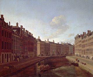
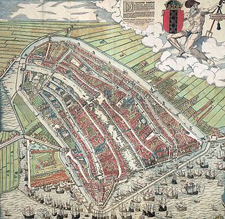
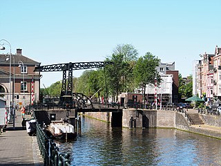
The Geldersekade was part of the city moat dug at the end of the 15th century that, together with the Kloveniersburgwal and the Singel, formed the Stedegracht around the city. The Geldersekade ran north from Sint Antoniespoort (now the Waag) on the Nieuwmarkt to the Schreierstoren on the IJ. A city wall was built on the city side, the western bank of the Geldersekade. This is clearly visible on the 1544 bird's-eye view map of Amsterdam by Cornelis Anthonisz. The eastern part, which was outside the city until 1585, was called the Cologne quay and then the Gelderland quay, and also the London quay or English quay for a short time. The names arose because there were jetties here where the ships from Gelderland, Cologne and England moored.
The Geldersekade lost its function as a moat after the Nieuwe Gracht (the current Oude Schans) was dug and new city walls were built. The old city wall was demolished and houses were built. The Lastage was developed between the Geldersekade and the Oudeschans.
A fish market was built after 1840 in the water of the Geldersekade, on the north side of the Nieuwmarkt. It replaced the fish market on Dam Square, which had to make way for the Beurs van Zocher. The scaffolding and wooden sheds were replaced in 1862 by the stone Gemeentelijke Vishal, which was demolished in 1938.
The entire quay has been called Geldersekade since 3 April 1912. In addition, the nearby Leliestraatje was given the name Geldersesteeg. [1]
The Herengracht is the second of four Amsterdam canals belonging to the canal belt and lies between the Singel and the Keizersgracht. The Gouden Bocht in particular is known for its large and beautiful canal houses.

Amsterdam, capital of the Netherlands, has more than 100 kilometers (62 mi) of grachten (canals), about 90 islands and 1,500 bridges. The three main canals, dug in the 17th century during the Dutch Golden Age, form concentric belts around the city, known as the Grachtengordel. Alongside the main canals are 1550 monumental buildings. The 17th-century canal ring area, including the Prinsengracht, Keizersgracht, Herengracht and Jordaan, were listed as UNESCO World Heritage Site in 2010, contributing to Amsterdam's fame as the "Venice of the North".

Gracht is a Dutch word for a canal within a city. Grachten often have a round shape and form a circle around the city cores in the Netherlands, Belgium and northern Germany. Outside the Netherlands, the word grachten mostly refers to the city canals of Amsterdam, for which it is well known.

The Nieuwezijds Voorburgwal is a street in the centre of Amsterdam. The street runs north-south without intersecting major streets other than the intersection with Raadhuisstraat at its halfway point, right behind the Royal Palace. On the eastern side it has a number of alleys connecting to Kalverstraat and Nieuwendijk.
Lastage is a neighborhood in the Centrum borough of Amsterdam, Netherlands. It is located between the Geldersekade and Oudeschans canals, just east of old medieval city. Today, the neighbourhood is also known as Nieuwmarktbuurt due to the fact that the Nieuwmarkt is comprised in the area; it is protected as a heritage site.

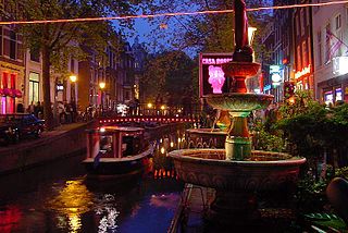
Zeedijk is a street in the old centre of Amsterdam. The street is the northern and eastern boundary of De Wallen red-light district and runs between Prins Hendrikkade and Nieuwmarkt. Historically an area riddled with crime and drug addicts, the area went through a revitalization and is now the main street of Amsterdam's Chinatown, where locals come to eat at Vietnamese, Thai and Chinese restaurants. The Zeedijk neighbourhood is also known as the Nautical Quarter because of its past as a sailors' neighbourhood.

The Waag is a 15th-century building on Nieuwmarkt square in Amsterdam. It was originally a city gate and part of the walls of Amsterdam. Later it served as a guildhall, museum, fire station and anatomical theatre, among other things.
The walls of Amsterdam were built in the Middle Ages to protect the city against attack. The Medieval walls were replaced with a series of bastions in the 17th century. In the 19th century, the walls were torn down and replaced with the Defence Line of Amsterdam, a fortification line which encircled Amsterdam at a distance from the city.

Kloveniersburgwal is an Amsterdam canal flowing south from Nieuwmarkt to the Amstel River on the edge of the medieval city, lying east of the dam in the centre of Amsterdam.
The Oudezijds Achterburgwal, often abbreviated to OZ Achterburgwal, is a street and canal in De Wallen, the red light district in the center of Amsterdam.

The Oudezijds Kolk is a short and narrow canal/lock in Amsterdam between the Oudezijds Voorburgwal and the Oosterdok.

The Raamgracht is a canal in central Amsterdam that runs from the Kloveniersburgwal to the Zwanenburgwal. The Groenburgwal, Verversstraat and Zanddwarsstraat lead to the Raamgracht. Bridge 225 over the canal is beside the Kloveniersburgwal, and Theo Boschbrug over the canal is beside the Zwanenburgwal.

The Oudeschans, or Oude Schans, originally the Nieuwe Gracht, is a wide canal in the eastern part of the inner city of Amsterdam.

The Snoekjesgracht is a small canal in Amsterdam, in the Lastage neighborhood.
The Schippersgracht is a canal and street in the Centrum district of Amsterdam that runs from the Rapenburgerplein to the Prins Hendrikkade.
Martelaarsgracht is a street and former canal in Amsterdam, the Netherlands.

The Nieuwezijds Achterburgwal is a former street and canal in Amsterdam, the Netherlands. From around 1380 to 1450 it was part of the town's defenses. The canal was filled in in 1866, and is now Spuistraat.

The Vijzelgracht is a street and former canal in Amsterdam. The Vijzelgracht is adjacent to the Grachtengordel and is an extension of one of the most important city radii for public transport and normal traffic. This through route leads via Vijzelstraat, Rokin, Dam Square and Damrak to Central Station. To the south of Vijzelgracht, the Nieuwe Vijzelstraat connects to Weteringschans.

Prins Hendrikkade is a major street in the centre of Amsterdam. It passes Amsterdam Central Station, intersects the Damrak at the mouth of the Amstel river, and forms the southern end of the IJtunnel across the IJ bay. The street formed the northern edge and outer harbour of the city until the 19th century. It was named after Prince Henry of the Netherlands, youngest son of King William II, following Henry's death in 1879.


