Location
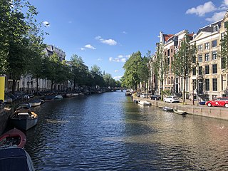
The Plantage Muidergracht canal forms the southwestern and southeastern boundary of the Plantage. The canal runs in a southeastern direction from the Nieuwe Keizersgracht, at the Hortus Botanicus. Before Sarphatistraat, it turns northeast and runs parallel to the Sarphatistraat along the south of the Artis zoo to the Entrepotdok. The Nieuwe Keizersgracht, Nieuwe Prinsengracht and Nieuwe Achtergracht open into the Plantage Muidergracht. The canal is bridged by Plantage Kerklaan and Plantage Middenlaan.
The Plantage Muidergracht street runs in a southeastern direction from the Plantage Parklaan, parallel to the Plantage Middenlaan. Because the street is partly enclosed by buildings, it does not border on the canal everywhere. Between numbers 33 and 51 there is an alley on the north side that was originally called Montefiorepark. At the end, the street and the canal make a turn in a northeasterly direction to the Plantage Middenlaan.
Part of Plantage Muidergracht borders here on the southeast side of the Artis zoo.
History
The Plantage Muidergracht was originally called the Muidergracht. Part of the Muidergracht was filled in in 1873 and is now the Jonas Daniël Meijerplein and the Hortusplantsoen. Part of the water has remained in the Hortusplantsoen, and this is now called the Hortus Pond. The part of the current Plantage Muidergracht that runs along Sarphatistraat, was an extension of the Lijnbaansgracht and was called the Plantage Lijnbaansgracht before 1915. The Roeterssloot, which culminated in the Plantage Muidergracht, was filled in in 1959.
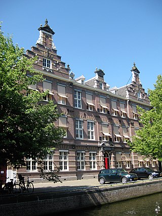
The Dutch poet and essayist Adriaan Morriën (1912–2002) lived at Plantage Muidergracht 3 and also named part one of his memoirs: Plantage Muidergracht. The Dutch journalist, writer and director Milo Anstadt (1920–2011) lived with his family at Plantage Muidergracht 89. Their house is described in Anstadt's book De verdachte oorboog. The sculptor Theresia van der Pant (19242013) lived and died at number 153.
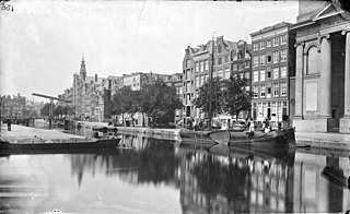
The Plantage Muidergracht, seen from the Schans (now Sarphatistraat) c. 1749.
1915 trams crossing Plantage Middenlaan
Aerial photo of the Roetersstraat and surroundings, seen in a northerly direction. In the middle under the Roetersstraat. Plantage Muidergracht in the middle from left to right. Behind it the Plantage neighborhood ; circa 1930.

The Prinsengracht is a 3.2-kilometer (2.0 mi)-long canal that runs parallel to the Keizersgracht in the center of Amsterdam. The canal, named after the Prince of Orange, is the fourth of the four main canals belonging to the canal belt.
The Keizersgracht is a canal in Amsterdam, the Netherlands. It is the second of the three main Amsterdam canals that together form the Grachtengordel, or canal belt, and lies between the inner Herengracht and outer Prinsengracht.

Amsterdam, capital of the Netherlands, has more than 100 kilometers (62 mi) of grachten (canals), about 90 islands and 1,500 bridges. The three main canals, dug in the 17th century during the Dutch Golden Age, form concentric belts around the city, known as the Grachtengordel. Alongside the main canals are 1550 monumental buildings. The 17th-century canal ring area, including the Prinsengracht, Keizersgracht, Herengracht and Jordaan, were listed as UNESCO World Heritage Site in 2010, contributing to Amsterdam's fame as the "Venice of the North".
Plantage is a neighbourhood of Amsterdam, Netherlands located in its Centrum borough. It is bordered by the Entrepotdok to the north, Plantage Muidergracht to the east and south and Nieuwe Herengracht to the west. In the centre of the neighbourhood lies the Natura Artis Magistra zoo. It had a population of 1,980 in 2017.

The Singelgracht is the waterway that borders the entire Amsterdam Center and flows along the Nassaukade, Stadhouderskade and Mauritskade streets. Formerly the canal and the ramparts on the city side formed the outer defenses of the city.
The Brouwersgracht is a canal in Amsterdam that connects the Singel with the Singelgracht. The canal marks the northwestern border of the Grachtengordel. Between the Prinsengracht and the Singelgracht the Brouwersgracht forms the northern border of the Jordaan neighborhood.
The Kadijken, also known as Kadijkseiland[kɑˈdɛiks.ɛiˌlɑnt] or Kadijkenbuurt[kɑˈdɛikə(m)ˌbyːrt], is a neighbourhood to the north of Artis zoo in the centre of Amsterdam. The name "Kadijken" is the plural form of Kadijk and refers to the two main streets that traverse the neighbourhood, Hoogte Kadijk and Laagte Kadijk.

Lijnbaansgracht is a partly filled-in canal in Amsterdam which bends beyond the boundary of the center, Amsterdam-Centrum. The canal runs parallel to the Singelgracht, between the Brouwersgracht and the Reguliersgracht.

The Sarphatistraat is a street in the center of Amsterdam between Frederiksplein and Oostenburgergracht at the Cruquiuskade. The street crosses the Amstel and forms an almost 2 kilometres (1.2 mi) long connection between the southern part of the Grachtengordel and the Oostelijke Eilanden.
The Nieuwe Herengracht is a canal in Centrum district of Amsterdam. The canal is an extension of the Herengracht that runs between the Amstel and the Scharrebiersluis (lock) leading to the Schippersgracht from the Entrepotdok. It is in the Plantage neighborhood in the eastern part of the Grachtengordel.

The Nieuwe Keizersgracht is a canal in Amsterdam, part of the eastern Grachtengordel.
The Nieuwe Prinsengracht is a canal in the Plantage neighborhood of Amsterdam, an extension of the Prinsengracht in the eastern Grachtengordel.

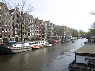
The Entrepotdok, formerly Nieuwe Rapenburgergracht, is a canal in Amsterdam, and a street and row of former warehouses with the same name along the northeast side of the canal. They were constructed between 1708 and 1829, used for storage, squatted in the 1990s and are now converted into apartments. Entrepotdok is the largest inhabited warehouse complex in Amsterdam. The canal runs between the Kadijksplein and Sarphatistraat, and is parallel to Hoogte Kadijk, Laagte Kadijk, Plantage Doklaan and Natura Artis Magistra zoo.

The Nieuwe Vaart or Nieuwevaart is a 17th-century canal in Amsterdam that runs from the center to Amsterdam-Oost.

The Looiersgracht is a short canal in Amsterdam, between Prinsengracht and Lijnbaansgracht in the Jordaan neighborhood of the Amsterdam-Centrum district. The Looiersgracht borders the Grachtengordel. The Oude Looiersstraat runs parallel to the canal, and the Eerste, Tweede and Derde Looiersdwarsstraat are side streets entering the north side.

The Leliegracht is a canal in Amsterdam, the Netherlands, between Herengracht and Prinsengracht. The canal lies within the western Grachtengordel in the Jordaan neighborhood of the Amsterdam-Centrum district.
The Nieuwe Achtergracht is a canal in Amsterdam in the east of the Grachtengordel in the Amsterdam-Centrum district. It runs parallel to the Nieuwe Prinsengracht and connects the Onbekendegracht with the Plantage Muidergracht. The canal is crossed by Weesperstraat and Roetersstraat.

The Elandsgracht is a street and former canal in Amsterdam, the Netherlands. It runs between the Prinsengracht and the Singelgracht in the Jordaan neighborhood of the Amsterdam-Centrum district. Bridge 169 over the Singelgracht and Bridge 107 over the Lijnbaansgracht connect the Elandsgracht in the direction of the Kinkerstraat. The Elandsgracht is in the west of the Grachtengordel. The Elandsstraat runs parallel to the Elandsgracht. There are houses, shops, cafés and restaurants on the former canal, with parking spaces in the middle.
The Houtgracht was a canal in Amsterdam that defined one side of Vlooyenburg island. Houtgracht and the connected Leprozengracht canal were filled in 1882 to form the Waterlooplein.


