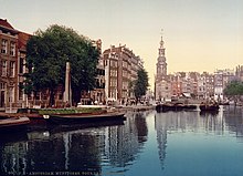
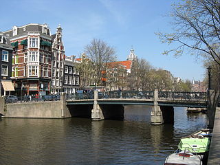
The Singel (Dutch pronunciation:[ˈsɪ.ŋəl]ⓘ) is one of the canals of Amsterdam. The Singel encircled Amsterdam in the Middle Ages, serving as a moat around the city until 1585, when Amsterdam expanded beyond the Singel. The canal runs from the IJ bay, near the Central Station, to the Muntplein square, where it meets the Amstel river. It is now the inner-most canal in Amsterdam's semicircular ring of canals.
The canal should not be confused with the Singelgracht, which became the outer limit of the city during the Dutch Golden Age in the 17th century. Other Dutch towns also have ring-shaped canals named Singel. The name is related to the Dutch word omsingelen, "to surround", and comes ultimately from Latin cingulum, meaning "belt".
Locations along the Singel
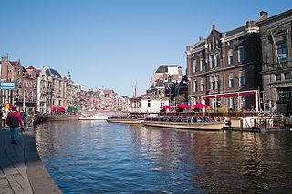
Amsterdam's famous flower market, Bloemenmarkt, is located along the Singel between Koningsplein and Muntplein squares. The market stalls are actually boats floating in the canal.
Part of the Singel has developed into a red-light district, with prostitutes offering their services from behind red-lit windows. The area, known as the Singelgebied, is located near Lijnbaanssteeg and Oude Nieuwstraat. Yab Yum, one of Amsterdam's most exclusive brothels until closed by the local authority in January 2008, was located at Singel 295.
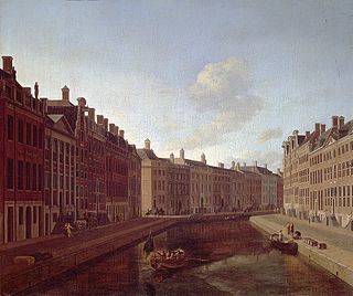
The Singel is lined by many beautiful, richly decorated canal houses built during the Dutch Golden Age. Notable buildings along the canal include:
A house said to be the narrowest in the world — only one meter wide (admittedly, this is the back of the house; the front is quite a bit wider), at Singel 7.
De Dolphijn, at Singel 140–142, a monumental canalside house built in ca. 1600, once inhabited by Frans Banning Cocq, the central figure in Rembrandt's painting The Night Watch.
The Oude Lutherse Kerk ("Old Lutheran Church"), at Singel 411, built in 1632–1633.
The Ronde Lutherse Kerk ("Round Lutheran Church"), also known as Koepelkerk or Nieuwe Lutherse Kerk, built in 1668–1671.
The Kalvertoren shopping center, between Koningsplein and Muntplein squares.
The Munttoren tower, originally part of a gate in the Medieval city walls, on Muntplein square, where the Singel meets the Amstel River.
The Haringpakkerstoren tower was part of Amsterdam's Medieval city defenses. The tower stood at the beginning of the Singel, near the IJ. It was demolished in 1829. The municipal government is currently considering a plan to rebuild the tower and adjacent houses. However, this plan remains highly controversial; opponents consider it in poor taste and a waste of money.
The Torensluis, built in 1648, is an arched and exceptionally wide bridge across the Singel. Now covered by cosy café terraces and a bust of Dutch writer Multatuli, the Torensluis is the oldest remaining bridge in Amsterdam, and also the widest bridge in Amsterdam (42 meters). The Jan Roodepoortstoren tower stood on one end of the bridge but was torn down in 1829. However, the tower's foundations remain part of the bridge. The entrance and barred windows of the tower's dungeon are still visible. The bridge, also known as Brug 9, crosses the Singel near Dam square, at Oude Leliestraat.
Other names
Up until the 15th century, the Singel was known as the Stedegracht ("City Canal"). In the 17th century the canal was known for some time as Koningsgracht ("King's Canal"), in honor of King Henry IV of France, who was an important ally of the Dutch Republic during the early part of the 17th century. Part of the canal, stretching from Spui square to Lijnbaanssteeg / Blauwburgwal, was also known at one time as Londense Kaai ("London Quay") or Engelse Kaai ("English Quay") because many ships sailing between Amsterdam and London moored there.
The Amstel is a river in the province of North Holland in the Netherlands. It flows from the Aarkanaal and Drecht in Nieuwveen northwards, passing Uithoorn, Amstelveen, and Ouderkerk aan de Amstel, to the IJ in Amsterdam, to which the river gives its name. Annually, the river is the location of the Liberation Day concert, Head of the River Amstel rowing match, and the Amsterdam Gay Pride boat parade.
The Rokin is a canal and major street in the centre of Amsterdam. The street runs from Muntplein square to Dam square. The Rokin canal used to run from Muntplein square to Dam Square, but in 1936, the part between Spui square and Dam Square was filled in. Canal boats are now moored on the remaining part of the water, from the Amstel to Grimburgwal.
The Spui is a square in the centre of Amsterdam, the capital of the Netherlands.
The Herengracht is the second of four Amsterdam canals belonging to the canal belt and lies between the Singel and the Keizersgracht. The Gouden Bocht in particular is known for its large and beautiful canal houses.
Amsterdam, capital of the Netherlands, has more than 100 kilometers (62 mi) of grachten (canals), about 90 islands and 1,500 bridges. The three main canals, dug in the 17th century during the Dutch Golden Age, form concentric belts around the city, known as the Grachtengordel. Alongside the main canals are 1550 monumental buildings. The 17th-century canal ring area, including the Prinsengracht, Keizersgracht, Herengracht and Jordaan, were listed as UNESCO World Heritage Site in 2010, contributing to Amsterdam's fame as the "Venice of the North".
The Muntplein is a square in the centre of Amsterdam. The square is in fact a bridge — the widest bridge in Amsterdam — that crosses the Singel canal at the point where it flows into the Amstel river. All bridges in Amsterdam are numbered, and the Muntplein carries the number 1.
The Ronde Lutherse Kerk or Koepelkerk is a former Lutheran church in Amsterdam, Netherlands, on the Singel canal. The church can be easily seen from the Singel, identified by its copper dome.
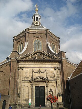
The Marekerk is a Protestant church in Leiden, located at the Lange Mare and the Oude Vest canal. The church can be easily seen from the Oude Vest and the Burcht van Leiden by its round dome.
The Korenbeurs was a 17th-century commodity market in Amsterdam where grain was traded. The building stood on the banks of the Amstel, on the western side (Nieuwezijde) of the Damrak. It was directly south of the Oude Brug bridge, on a spot now occupied by the former stock and commodity exchange Beurs van Berlage.
The walls of Amsterdam were built in the Middle Ages to protect the city against attack. The Medieval walls were replaced with a series of bastions in the 17th century. In the 19th century, the walls were torn down and replaced with the Defence Line of Amsterdam, a fortification line which encircled Amsterdam at a distance from the city.
Kloveniersburgwal is an Amsterdam canal flowing south from Nieuwmarkt to the Amstel River on the edge of the medieval city, lying east of the dam in the centre of Amsterdam.
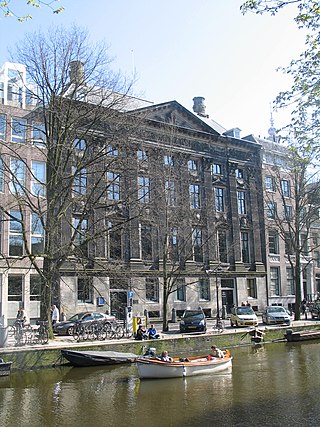
The Handboogdoelen is a building on the Singel canal in Amsterdam, near Koningsplein square. It dates back to the early 16th century and originally served as headquarters and shooting range of the local schutterij. Most of the current building at Singel 421 dates to the 18th century and is part of the main complex of the Amsterdam University Library. The Doelenzaal hall on the ground floor of the building is used for lectures, meetings, receptions and doctoral dissertations. The building has rijksmonument status.
The Oudezijds Voorburgwal, often abbreviated to OZ Voorburgwal, is a street and canal in De Wallen in the center of Amsterdam. It runs from the Grimburgwal in the south to the Zeedijk in the north, where it changes into the Oudezijds Kolk, which drains into the IJ.
The Geldersekade is a canal and a street in Amsterdam that connects the Nieuwmarkt with the Prins Hendrikkade. The Geldersekade is in the easternmost part of De Wallen, the red light district, and borders Chinatown.
Martelaarsgracht is a street and former canal in Amsterdam, the Netherlands.
The Spuistraat in downtown Amsterdam connects the Hekelveld to the Spui. It runs roughly north to south, parallel to the Singel and the Nieuwezijds Voorburgwal. At the Royal Palace of Amsterdam, the Spuistraat crosses the Raadhuisstraat and Paleisstraat. Originally the Spuistraat was a canal, the Nieuwezijds Achterburgwal. The canal was filled up in 1867, and the street was then renamed.
Prins Hendrikkade is a major street in the centre of Amsterdam. It passes Amsterdam Central Station, intersects the Damrak at the mouth of the Amstel river, and forms the southern end of the IJtunnel across the IJ bay. The street formed the northern edge and outer harbour of the city until the 19th century. It was named after Prince Henry of the Netherlands, youngest son of King William II, following Henry's death in 1879.
The following is an alphabetical list of articles related to Amsterdam. Amsterdam is the capital city of the Netherlands.
This page is based on this Wikipedia article Text is available under the CC BY-SA 4.0 license; additional terms may apply. Images, videos and audio are available under their respective licenses.