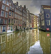
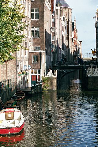
The Oudezijds Voorburgwal, often abbreviated to OZ Voorburgwal, is a street and canal in De Wallen in the center of Amsterdam. It runs from the Grimburgwal in the south to the Zeedijk in the north, where it changes into the Oudezijds Kolk, which drains into the IJ.
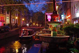
The bridge over the OZ Voorburgwal between Damstraat and Oude Doelenstraat (bridge 204) forms a clear dividing line between the noisy northern Wallendeel and the quiet southern part. It is one of the most famous streets of the Red Light District, full of sex shops, window prostitutes, peep shows, brothels, bars and coffee shops. The Bulldog has several branches and a hotel here. The canal is also lined with monumental canal houses from the Dutch Golden Age, and the remains of the many monasteries that were located here in the Middle Ages.
History
The OZ Voorburgwal was originally a creek that was later dug into a canal around the eastern part of the city, the old side. Before 1385 the Amstel divided the city of Amsterdam into two almost equal parts, the old side with the Old Church and the new side with the New Church. To protect the city, a moat was dug on each side with a burgwal behind it, an earthen wall, with a wooden palisade for protection. When new ramparts were constructed behind these ramparts around 1385, on both the old and new sides the existing rampart became the Voorburgwal and the new rampart became the Achterburgwal. That is how Oudezijds Voorburgwal, Oudezijds Achterburgwal, Nieuwezijds Voorburgwal and Nieuwezijds Achterburgwal (now Spuistraat) were created.
In the 17th and 18th centuries the canal was usually called the Fluwelenburgwal. When the buildings on the Oudezijds Voorburgwal were built in the Golden Age, canal gardens were laid out behind the mansions. Almost all of them have since disappeared.
The Bierkaai (beer quay) was the quay on the Oudezijds Voorburgwal, near the Oude Kerk, where barrels of beer arrived and porters loaded and unloaded the heavy barrels. The residents of this part of Amsterdam were known as invincible fighters. The proverbial "fight against the beer quay" is derived from this: dedication to a hopeless cause.
Famous buildings
The Oude Kerk is the most important monumental building on the Oudezijds Voorburgwal.
There are more than a hundred national monuments on Oudezijds Voorburgwal. Some well-known buildings there include:
The Prinsenhof (OZ Voorburgwal 197), now the five-star hotel The Grand. This former monastery was converted into the Prinsenhof after the Alteratie (Alteration) in 1578. When King Louis Bonaparte moved to the Royal Palace in 1808, the city council moved to the Prinsenhof. The building served as Amsterdam's town hall until the Stopera became operational in 1988. The extension of the City Hall with modern façade in the Amsterdam School style to a design by Nicolaas Lansdorp dates from 1926.
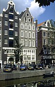
De Gecroonde Raep (OZ Voorburgwal 57), a house built by Hendrick de Keyser. This is a well-known example of a stepped gable in the Amsterdam Renaissance style of De Keyser.Oudezijds Voorburgwal with the striking stepped gable of Het Wapen van Riga (OZ Voorburgwal 14), a 17th-century merchant's house
Het Wapen van Riga (OZ Voorburgwal 14), a 17th-century merchant's house.
Vredenburgh, a building whose oldest parts date from the 15th century.
The Huis aan de Drie Grachten (House on the Three Canals) stands at the southern end of the Oudezijds Voorburgwal at the point where this canal meets the Oudezijds Achterburgwal and the Grimburgwal.The extension of the city hall with modern façade in the Amsterdam School style to a design by N. Lansdorp from 1926
Bridges
The Oudezijds Achterburgwal is spanned by eight bridges, all fixed.
With the passage heights in the table, one must take into account the fact that the Oudezijds Achterburgwal, like all other canals in the city center, is 0.40 metres (1ft 4in) below the NAP.
Notes on the three northern bridges:
the Arm Bridge was never an arched bridge, but was built as a flat bridge and was modernized as such
the Liesdelburg was an arch bridge, became a flat beam bridge and was restored as an arch
the Oudekerks bridge was a wooden bridge and was not converted into an arch bridge until the late 20th century ("architectural lie")
Gallery
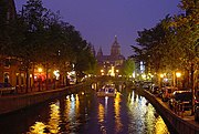
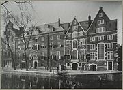
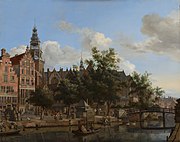
On the north side of the Oudezijds Voorburgwal, the view is dominated by the St. Nicholas Basilica. Photo from around 1890.
Oudezijds Voorburgwal and silhouette of St. Nicholas' Basilica by night
The Singel is one of the canals of Amsterdam. The Singel encircled Amsterdam in the Middle Ages, serving as a moat around the city until 1585, when Amsterdam expanded beyond the Singel. The canal runs from the IJ bay, near the Central Station, to the Muntplein square, where it meets the Amstel river. It is now the inner-most canal in Amsterdam's semicircular ring of canals.
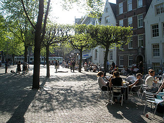
The Spui is a square in the centre of Amsterdam, the capital of the Netherlands.
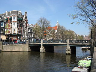
Amsterdam, capital of the Netherlands, has more than 100 kilometers (62 mi) of grachten (canals), about 90 islands and 1,500 bridges. The three main canals, dug in the 17th century during the Dutch Golden Age, form concentric belts around the city, known as the Grachtengordel. Alongside the main canals are 1550 monumental buildings. The 17th-century canal ring area, including the Prinsengracht, Keizersgracht, Herengracht and Jordaan, were listed as UNESCO World Heritage Site in 2010, contributing to Amsterdam's fame as the "Venice of the North".
The Oudekerksplein is a square in the centre of Amsterdam. It is named after the 14th-century church Oude Kerk which dominates the square. The Oudekerksplein is wedged between the Warmoesstraat street and Oudezijds Voorburgwal canal. From the square, the Oudekerksbrug bridge crosses the Oudezijds Voorburgwal canal and continues eastwards, through the Oudekennissteeg and Molensteeg alleys, towards the Oudezijds Achterburgwal and Zeedijk.
The Nieuwezijds Voorburgwal is a street in the centre of Amsterdam. The street runs north-south without intersecting major streets other than the intersection with Raadhuisstraat at its halfway point, right behind the Royal Palace. On the eastern side it has a number of alleys connecting to Kalverstraat and Nieuwendijk.
Hotel Die Port van Cleve is a historical 4-star hotel on the Nieuwezijds Voorburgwal in Amsterdam. The hotel is situated in the centre of Amsterdam, immediately north of the Magna Plaza shopping centre, and west of the Royal Palace on the Dam Square.
The Huis aan de Drie Grachten or Huis op de Drie Grachten is a 17th-century canal house in Amsterdam, at the southeastern end of the Wallen district. The name is a reference to the fact that the building faces three different Amsterdam canals. The south facade faces Grimburgwal, the west facade faces Oudezijds Voorburgwal and the east facade faces Oudezijds Achterburgwal. The address is Oudezijds Voorburgwal 249.
The walls of Amsterdam were built in the Middle Ages to protect the city against attack. The Medieval walls were replaced with a series of bastions in the 17th century. In the 19th century, the walls were torn down and replaced with the Defence Line of Amsterdam, a fortification line which encircled Amsterdam at a distance from the city.
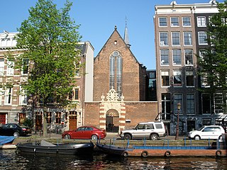
The Walloon Church is a Protestant church building in Amsterdam, along the southern stretch of the Oudezijds Achterburgwal canal. The building dates to the late 15th century and has been in use as a Walloon church since 1586. The church was also known as the Franse Kerk, Walenkerk, Oude Walenkerk, or Oude Waalse Kerk.
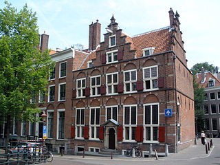
The Agnietenkapel is a 15th-century Gothic chapel in Amsterdam. It is the birthplace of the University of Amsterdam and still in use for doctoral dissertations and other university ceremonies, as well as academic events such as lectures and symposiums. The building has held rijksmonument status since 1970.
The Grimburgwal is a small canal and street in the center of Amsterdam.
The Oudezijds Achterburgwal, often abbreviated to OZ Achterburgwal, is a street and canal in De Wallen, the red light district in the center of Amsterdam.
The Oudezijds Kolk is a short and narrow canal/lock in Amsterdam between the Oudezijds Voorburgwal and the Oosterdok.
The Geldersekade is a canal and a street in Amsterdam that connects the Nieuwmarkt with the Prins Hendrikkade. The Geldersekade is in the easternmost part of De Wallen, the red light district, and borders Chinatown.
Martelaarsgracht is a street and former canal in Amsterdam, the Netherlands.
The Spuistraat in downtown Amsterdam connects the Hekelveld to the Spui. It runs roughly north to south, parallel to the Singel and the Nieuwezijds Voorburgwal. At the Royal Palace of Amsterdam, the Spuistraat crosses the Raadhuisstraat and Paleisstraat. Originally the Spuistraat was a canal, the Nieuwezijds Achterburgwal. The canal was filled in in 1867, and the street renamed then.
The Queen's Head is a gay bar located at Zeedijk 20 in the centre of Amsterdam. It opened in 1998 and is known for its drag queen bingo evenings.
This page is based on this Wikipedia article Text is available under the CC BY-SA 4.0 license; additional terms may apply. Images, videos and audio are available under their respective licenses.