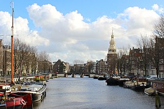
Prins Hendrikkade

Last updated
Prins Hendrikkade
Nicolaas1.jpg
Part of Prins Hendrikkade viewed from the north, with the Schreierstoren (left), the northern end of Geldersekade canal (centre), and the Basilica of Saint Nicholas (right)
Amsterdam centre map.png
Red pog.svg
Location in the city center of Amsterdam
Location Amsterdam, Netherlands
Postal code 1011 AG-AW, 1011 TB-TD, 1011 VC, 1012 AC-AE, 1012 TK-TM
Coordinates 52°22′25″N4°54′22″E / 52.37361°N 4.90611°E / 52.37361; 4.90611 Coordinates: 52°22′25″N4°54′22″E / 52.37361°N 4.90611°E / 52.37361; 4.90611
West end Singel canal, Haarlemmersluis
East end Kattenburgerplein

Prins Hendrikkade (Dutch for "Prince Henry's Quay") is a major street in the centre of Amsterdam. It passes Amsterdam Central Station, intersects the Damrak at the mouth of the Amstel river, and forms the southern end of the IJtunnel across the IJ bay. The street formed the northern edge and outer harbour of the city until the 19th century. It was named after Prince Henry of the Netherlands, youngest son of King William II, following Henry's death in 1879.

Contents

The Prins Hendrikkade runs roughly northwest to southeast, from the northern end of Singel canal to Kattenburgerplein square. Car traffic is banned from the part of the street directly in front of Amsterdam Central Station, between Martelaarsgracht and Damrak. The street continues in westerly direction as Nieuwe Westerdokstraat and Haarlemmerhouttuinen. At the eastern end, the street turns north at Kattenburgerplein and continues as Kattenburgerstraat. The body of water between Prins Hendrikkade and the train station is known as Open Havenfront and, further east, as Oosterdok.

Along the street are 99 buildings that have been listed as national monument ( rijksmonument ). [1] Prominent buildings on the street include the Basilica of Saint Nicholas, the Schreierstoren, the Scheepvaarthuis, and Victoria Hotel. Along the eastern part of the street are a number of quays where houseboats are moored.

Claude Monet, View of the Prins Hendrikkade and the Kromme Waal in Amsterdam, 1874. Van Gogh Museum Claude Monet - View of the Prins Hendrikkade and the Kromme Waal in Amsterdam - Google Art Project.jpg
Claude Monet, View of the Prins Hendrikkade and the Kromme Waal in Amsterdam, 1874. Van Gogh Museum

Prins Hendrikkade has been depicted by various artists, including Claude Monet, who painted it in 1874.

Public transport

Amsterdam Central Station, the city's main train station, is situated just north of the street. The Amsterdam Central Station stop of the Amsterdam Metro has an entrance on Prins Hendrikkade, just east of the Basilica of Saint Nicholas. A number of bus lines also have a stop at Prins Hendrikkade. Tram lines 4 and 14 traverse part of Prins Hendrikkade between Amsterdam Central Station and Dam Square, but do not stop on the street itself.

Canal tour boats (so-called rondvaartboten) are moored on Prins Hendrikkade near the station. Water taxis have a stop near the Scheepvaarthuis (Grand Hotel Amrâth).

History

The Prins Hendrikkade originally formed the Open Havenfront, the northern edge and outer harbour of the city, along the IJ waterfront. This lasted until the 19th century, when Amsterdam Central Station was built on artificial islands north of Prins Hendrikkade.

Original streets

The street was named in 1879 after Prince Henry of the Netherlands (who died in that year), replacing a patchwork of existing street names, from west to east: Haringpakkerij, Tesselse Kade, Oude Teertuinen, Kamperhoofd and Buitenkant.

The westernmost section, between Haarlemmersluis (at the northern end of the Singel canal) and Martelaarsgracht, was originally known as Haringpakkerij because the area was used for the local herring industry. A defensive tower known as the Haringpakkerstoren stood here until it was demolished in the 19th century. East of the Haringpakkerij, the street was originally known as Tesselse Kade or Texelse Kade ("Texel Quay"). This narrow quay replaced an area that was used as timber yards (houttuinen) until the 17th century. After the artificial islands for Amsterdam Central Station were constructed in 1872–1879, the Tesselse Kade was broadened and renamed Prins Hendrikkade. A small park known as Prins Hendrikplantsoen was constructed on the now wide street, and a bust of Prince Henry was placed in the park (the bust was moved to the eastern part of Prins Hendrikkade in 1979). The terrain sloped down gently from the Prins Hendrikkade to a quay along the waterside. This quay was replaced in the 1960s by docks for canal tour boats operated by the company of J.H. Bergmann. [2]

The Paalhuis and Nieuwe Brug, seen from the IJ, painted by Jan Abrahamsz Beerstraaten in 1663. Amsterdam Museum SA 7291-Het Paalhuis en de Nieuwe Brug, gezien vanaf het IJ.jpg
The Paalhuis and Nieuwe Brug, seen from the IJ, painted by Jan Abrahamsz Beerstraaten in 1663. Amsterdam Museum

At the intersection with the Damrak, where the Amstel river flows into the IJ bay, the Prins Hendrikkade runs across the river's mouth on the Nieuwe Brug ("new bridge"). The first bridge here was constructed in the late 13th or early 14th century. In 1560 the Paalhuis was built adjacent to the bridge to collect customs duties on shipping. This Renaissance building was demolished in the middle of the 17th century.

East of the Damrak, the street was originally known as Teertuinen ("tar yards") because the area was used to store tar. The storage of this highly flammable substance presented a serious fire hazard, so in 1664 the storage of tar was moved to newly constructed artificial islands known as the Westelijke Eilanden. Subsequently, the street continued to be known as the Oude Teertuinen ("former tar yards"). The section at the northern end of Oudezijds Kolk canal was known as Kamperhoofd. A large cannon was placed on the city walls at Kamperhoofd, which formed the northernmost point of the Medieval city. [3]

The easternmost part of the street was originally known as Buitenkant ("outside"), a name reflected in the street name Binnenkant ("inside") which still exists opposite this section of the street.

21st-century modernisation

In 2018, the part of the street directly in front of Amsterdam Central Station, between Martelaarsgracht and Damrak, was made car-free in an effort to reduce east–west car traffic through the city centre and simplify the often chaotic traffic situation in front of the station. East–west traffic is since led along the northern side of the station. [4]

The city government has announced plans to modernise the eastern part of Prins Hendrikkade in order to make the area safer for pedestrian and bicycle traffic. The project is expected to start in 2023. [5]

Trivia

See also

Related Research Articles

Singel Street and canal in Amsterdam

The Singel is one of the canals of Amsterdam. The Singel encircled Amsterdam in the Middle Ages, serving as a moat around the city until 1585, when Amsterdam expanded beyond the Singel. The canal runs from the IJ bay, near the Central Station, to the Muntplein square, where it meets the Amstel river. It is now the inner-most canal in Amsterdam's semicircular ring of canals.

Herengracht Canal in Amsterdam

The Herengracht is the second of four Amsterdam canals belonging to the canal belt and lies between the Singel and the Keizersgracht. The Gouden Bocht in particular is known for its large and beautiful canal houses.

Canals of Amsterdam Grachten dug in the 17th century during the Dutch Golden Age; UNESCO World Heritage Site

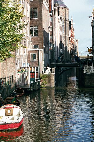
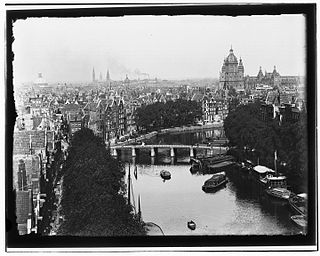
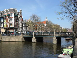
Amsterdam, capital of the Netherlands, has more than 100 kilometers (62 mi) of grachten (canals), about 90 islands and 1,500 bridges. The three main canals, dug in the 17th century during the Dutch Golden Age, form concentric belts around the city, known as the Grachtengordel. Alongside the main canals are 1550 monumental buildings. The 17th-century canal ring area, including the Prinsengracht, Keizersgracht, Herengracht and Jordaan, were listed as UNESCO World Heritage Site in 2010, contributing to Amsterdam's fame as the "Venice of the North".

<i>Gracht</i> Dutch waterway in the city with streets on both sides of the water

Gracht is a Dutch word for a canal within a city. Grachten often have a round shape and form a circle around the city cores in the Netherlands, Belgium and northern Germany. Outside the Netherlands, the word grachten mostly refers to the city canals of Amsterdam, for which it is well known.

Nieuwezijds Voorburgwal Street in Amsterdam

The Nieuwezijds Voorburgwal is a street in the centre of Amsterdam. The street runs north-south without intersecting major streets other than the intersection with Raadhuisstraat at its halfway point, right behind the Royal Palace. On the eastern side it has a number of alleys connecting to Kalverstraat and Nieuwendijk.

Eastern Docklands Neighborhood of Amsterdam in North Holland, Netherlands

The Eastern Docklands is a neighborhood of Amsterdam, Netherlands, located between the IJ and the Amsterdam–Rhine Canal in the borough of Amsterdam-Oost. The harbor area was constructed in the late nineteenth century to allow for increasing trade with the Dutch East Indies; a new location was necessitated by the construction of the Amsterdam Centraal railway station, which replaced the old quays. East of the new station was a marshy area called De Rietlanden, with the Zeeburgerdijk, running via the Zeeburch, a fort, to the Zuiderzee.

Singelgracht Canal in Amsterdam

The Singelgracht is the waterway that borders the entire Amsterdam Center and flows along the Nassaukade, Stadhouderskade and Mauritskade. Formerly the canal and the ramparts on the city side formed the outer defenses of the city.

Kloveniersburgwal, Amsterdam

Kloveniersburgwal is an Amsterdam canal flowing south from Nieuwmarkt to the Amstel River on the edge of the medieval city, lying east of the dam in the centre of Amsterdam.

Scheepvaarthuis

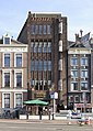
The Shipping House is a building on the western tip of the Waalseiland near Amsterdam harbour that is one of the top 100 Dutch heritage sites and generally regarded as the first true example of the Amsterdam School, a style characterised by "expressive dynamism, lavish ornamentation and colourful embellishments". It is situated on the Prins Hendrikkade and was erected on the spot where Cornelis Houtman's first trip to the East Indies had begun in 1595. The first part was built 1913 - 1916 ; the second part was built 1926 -1928. Originally, it was the headquarters of six leading Amsterdam shipping companies: the Netherlands Steamship Company (SMN), the Royal Packet Navigation Company (KPM), the Java-China-Japan Line (JCJL) and the Royal Dutch Steamboat Company (KNSM) with subsidiary New Rhine Navigation Company (NRM) and acquired in 1912 Royal West India Mail Service (KWIM).

Fietsflat

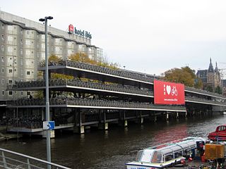
The Fietsflat is a 3-storey free-to-use public bicycle parking facility in Amsterdam. It is located on Stationseiland island next to Amsterdam Central Station and has place for 2500 bicycles. The name is derived from fiets (bicycle) and flat, an originally English word which the Dutch use to denote multi-level apartment complexes.

Nieuwendijk, Amsterdam Street in Amsterdam

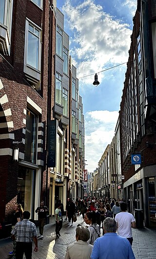
The Nieuwendijk is a major shopping street in central Amsterdam. There are some 200 shops along the street. The street, which dates to the early medieval history of Amsterdam, counts 98 buildings with rijksmonument status.

Oudezijds Kolk Canal in Amsterdam

The Oudezijds Kolk is a short and narrow canal/lock in Amsterdam between the Oudezijds Voorburgwal and the Oosterdok.

Kromme Waal Street in Amsterdam

The Kromme Waal is a street in Amsterdam between the Prins Hendrikkade and the Oude Waal. From Kraansluis to Waalseilandbrug, the street forms the western quay of the Waalseilandsgracht, the old inner harbor of Amsterdam between the Montelbaanstoren and the IJ.

Geldersekade Canal in Amsterdam

The Geldersekade is a canal and a street in Amsterdam that connects the Nieuwmarkt with the Prins Hendrikkade. The Geldersekade is in the easternmost part of De Wallen, the red light district, and borders Chinatown.

Oudeschans, Amsterdam Canal in Amsterdam

The Oudeschans, or Oude Schans, originally the Nieuwe Gracht, is a wide canal in the eastern part of the inner city of Amsterdam.

Waalseilandsgracht Canal in Amsterdam

The Waalseilandsgracht, or Waalseilandgracht, is a short, wide canal in the east part of the inner city of Amsterdam.

Schippersgracht Canal in Amsterdam

The Schippersgracht is a canal and street in the Centrum district of Amsterdam that runs from the Rapenburgerplein to the Prins Hendrikkade.

Martelaarsgracht Canal in Amsterdam

Martelaarsgracht is a street and former canal in Amsterdam, the Netherlands.

Vijzelgracht Canal in Amsterdam

The Vijzelgracht is a street and former canal in Amsterdam. The Vijzelgracht is adjacent to the Grachtengordel and is an extension of one of the most important city radii for public transport and normal traffic. This through route leads via Vijzelstraat, Rokin, Dam Square and Damrak to Central Station. To the south of Vijzelgracht, the Nieuwe Vijzelstraat connects to Weteringschans.

Oosterdok

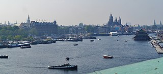
The Oosterdok is a former wet dock in Amsterdam. It was created in 1831-1832 by constructing the Oosterdoksdam and the Oosterdoksluis, forming a reliable deep port closed off from the tidal IJ.

References

  1. Rijksmonumentenregister (in Dutch)
  2. "Cultuurhistorische verkenning Fietsenstalling Kade OHF Midden Zuidzijde", Gemeente Amsterdam, February 2014 (in Dutch)
  3. Peter-Paul de Baar, "Prins Hendrikkade 86. Reders, cargadoors, kolenhandelaren en een tandarts", Ons Amsterdam, 1 January 2011 (in Dutch)
  4. "Zondagochtend komt het tijdperk van de auto ten einde", Het Parool, 22 July 2018 (in Dutch)
  5. "Prins Hendrikkade Oost: herinrichting", Gemeente Amsterdam (in Dutch)
  6. Pareles, Jon (May 14, 1988). "Chet Baker, Jazz Trumpeter, Dies at 59 in a Fall". NYTimes.com. Retrieved March 25, 2016.