Kadijken

Last updated
De Kadijken
Neighborhood of Amsterdam
Coordinates: 52°22′8″N4°54′56″E / 52.36889°N 4.91556°E / 52.36889; 4.91556
Country Netherlands
Province North Holland
COROP Amsterdam
Time zone UTC+1 (CET)

The Kadijken, also known as Kadijkseiland or Kadijkenbuurt, is a neighbourhood to the north of Artis zoo in the centre of Amsterdam. The name "Kadijken" is the plural form of Kadijk and refers to the two main streets that traverse the neighbourhood, Hoogte Kadijk ("Upper Kadijk") and Laagte Kadijk ("Lower Kadijk"). [1]

Contents

Description

Entrepotdok viewed from the Nijlpaardenbrug bridge Entrepotdok.jpg
Entrepotdok viewed from the Nijlpaardenbrug bridge
Southwestern point of the Kadijken, with Nieuwe Herengracht canal (left), the Scharrebiersluis sluice gates (centre) and Entrepotdok (right) Nieuwe herengracht entrepotdok scharrebiersluis amsterdam.jpg
Southwestern point of the Kadijken, with Nieuwe Herengracht canal (left), the Scharrebiersluis sluice gates (centre) and Entrepotdok (right)

The Kadijken, a rectangular area measuring 900 by 170 metres, is bordered by Nieuwe Herengracht and Schippersgracht to the west, Nieuwe Vaart canal to the north, Sarphatistraat street to the east, and Entrepotdok canal to the south. The neighbourhood is cut into two halves, a larger western part and a smaller eastern part, by a former complex of sluice gates that forms a canal between the Nieuwe Vaart and Entrepotdok canals. This canal isolates the western part of the neighbourhood from the rest of the city, making it a de facto island. [1]

Connecting the two main streets, Hoogte en Laagte Kadijk, is a small street appropriately named Tussen Kadijken ("Between the Kadijken"). The small street Buiten Kadijken ("Outer Kadijken") runs from Hoogte Kadijk to Nieuwe Vaart canal. At the corner of Hoogte Kadijk and Buiten Kadijken is a pillar topped with a sculpture of a falcon with a crown on its head. This is a replica of a cast-iron sculpture that stood here for many years as a trademark of the beer brewery De Gekroonde Valk ("The Crowned Falcon"), which has been located here since the 18th century.

The western edge of the neighbourhood is formed by Kadijkenplein square with the Zeemanshuis ("Seamen's House") and the gate building of the Algemeen Rijksentrepot, both dating to the 19th century. From the square, a cast-iron bridge leads across Nieuwe Herengracht canal. Behind the bridge are the Scharrebiersluis sluice gates. Both the bridge and the sluice gates were constructed in 1906.

The neighbourhood has about 3,000 inhabitants. There about 1,700 residences, primarily in the western part of the neighbourhood. Of those, 70% is rented (60% government-subsidised apartments and 10% private rental), and the remaining 30% is privately owned. The eastern part of the neighbourhood is less residential; this area is dominated by offices and workshops. [1]

The many former warehouses and shipyards in the Kadijken are a reminder of the neighbourhood's past as an area of town dominated by shipping and industry. Werfmuseum 't Kromhout and Koning William, both on Hoogte Kadijk, are still in use as shipyards. The eastern hall of Werfmuseum 't Kromhout is now a museum.

The neighbourhood has a large number of rijksmonumenten (national monuments), including the warehouses on Entrepotdok, the Sibbelwoningen on Hoogte Kadijk and a series of 17th- and 18th-century houses.

History

The Kadijken were created during the fourth 17th-century expansion of Amsterdam, completed in 1663, in which an area of land beyond the dikes protecting the eastern side of Amsterdam was added to the city. In this area, a kadijk-type dike, the Nieuwe Zeedijk, had been constructed beyond the original Sint Antoniesdijk dike. A kadijk is the outer, lower dike (levee) within a set of two dikes to keep a river (or, in this instance, the IJ bay), from flooding. During the city expansion, the Nieuwe Zeedijk was raised and the higher part was called Hoogte Kadijk, while the lower part lying behind the dike came to be called Laagte Kadijk.

The Kadijken rapidly developed into an area dominated by shipyards. The south side was originally used for recreation, but from the early part of the 18th century this part of the neighbourhood was filled with warehouses and other buildings for storage of goods. In 1827 the Rapenburgergracht, as the canal along the southern edge of the neighbourhood was called, was taken over by the Dutch national government. The government established the Algemeen Rijksentrepot there, which allowed goods in transit to be temporarily stored and transferred from one ship to another without the need to pay excise duties. With a total of 96 warehouses stretching 800 metres, this was one of the largest complexes of warehouses in Europe. The Rapenburgergracht was renamed Entrepotdok. [1]

The industrial character of the neighbourhood did not start to fade until the 20th century. From the 1970s onwards, hundreds of government-subsidised apartments were built, both in former warehouses and in newly constructed buildings. [1]

The museum EnergeticA was located in a former power station from 1903 on Hoogte Kadijk. The museum closed in 2007, and the collection was taken over by science centre NEMO.

Related Research Articles

<i>Van der Valk</i>

Van der Valk is a British television crime drama series about a detective in Amsterdam, based on the novels of Nicolas Freeling. The main character, Simon "Piet" van der Valk, was played by Barry Foster from 1972 to 1992, and by Marc Warren in 2020.

Amsterdam-Noord Borough of Amsterdam in North Holland, Netherlands

Amsterdam-Noord is a borough of Amsterdam, Netherlands with a population of about 90,000. The IJ, the body of water which separates it from Amsterdam-Centrum and the rest of the city, is situated southwest of Amsterdam-Noord. The borough, which has an area of 49.01 km2, borders the municipalities of Zaanstad, Oostzaan, Landsmeer and Waterland to the north, all part of the province of North Holland like Amsterdam. It borders the Markermeer to the east.

Herengracht Canal in Amsterdam

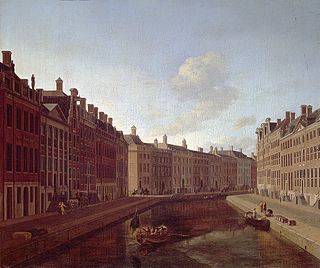
The Herengracht is the second of four Amsterdam canals belonging to the canal belt and lies between the Singel and the Keizersgracht. The Gouden Bocht in particular is known for its large and beautiful canal houses.

Canals of Amsterdam Grachten dug in the 17th century during the Dutch Golden Age; UNESCO World Heritage Site

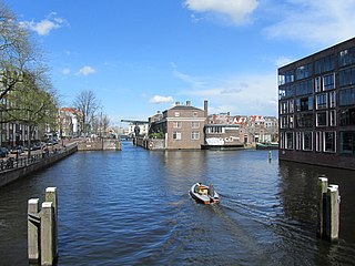
Amsterdam, capital of the Netherlands, has more than one hundred kilometers of grachten (canals), about 90 islands and 1,500 bridges. The three main canals, dug in the 17th century during the Dutch Golden Age, form concentric belts around the city, known as the Grachtengordel. Alongside the main canals are 1550 monumental buildings. The 17th-century canal ring area, including the Prinsengracht, Keizersgracht, Herengracht and Jordaan, were listed as UNESCO World Heritage Site in 2010, contributing to Amsterdam's fame as the "Venice of the North".

Plantage Neighbourhood of Amsterdam in North Holland, Netherlands

Plantage is a neighbourhood of Amsterdam, Netherlands located in its Centrum borough. It is bordered by the Entrepotdok to the north, Plantage Muidergracht to the east and south and Nieuwe Herengracht to the west. In the centre of the neighbourhood lies the Natura Artis Magistra zoo. It had a population of 1,980 in 2017.

Westelijke Eilanden (Amsterdam) Neighborhood of Amsterdam in North Holland, Netherlands

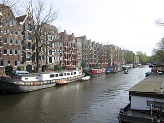
Westelijke Eilanden are three islands in the Centrum district of Amsterdam: Bickerseiland, Prinseneiland and Realeneiland. They are located to the south of the IJ and the Zeeheldenbuurt, to the north of the railway line between Central Station and Amsterdam-Sloterdijk, to the west of the Westerdok and to the east of the Planciusbuurt on the Westerkanaal. The Westelijke Eilanden form the core of the Golden Reael area, which also includes the adjacent Westerdok island, the Haarlemmerbuurt and the Planciusbuurt.

Brouwersgracht Canal in Amsterdam

The Brouwersgracht is a canal in Amsterdam that connects the Singel with the Singelgracht. The canal marks the northwestern border of the Grachtengordel. Between the Prinsengracht and the Singelgracht the Brouwersgracht forms the northern border of the Jordaan neighborhood.

Amsterdam-Centrum Borough of Amsterdam in North Holland, Netherlands

Amsterdam-Centrum is the inner-most borough and historical city centre of Amsterdam, Netherlands containing the majority of the city's landmarks. Established in 2002, Amsterdam-Centrum was the last area in the city to be granted the status of self-governing borough. The borough is only 8.04 km2 large and covers the old innercity and the UNESCO-listed Amsterdam canal belt. In 2013, the borough had approximately 85,000 inhabitants, who on average had the second-highest income per household in the city and one of the highest in the country.

Zeedijk

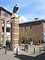
Zeedijk is a street in the old centre of Amsterdam. The street is the northern and eastern boundary of De Wallen red-light district and runs between Prins Hendrikkade and Nieuwmarkt. Historically an area riddled with crime and drug addicts, the area went through a revitalization and is now the main street of Amsterdam's Chinatown, where locals come to eat at Vietnamese, Thai and Chinese restaurants. The Zeedijk neighbourhood is also known as the Nautical Quarter because of its past as a sailors' neighbourhood.

Schielands Hoge Zeedijk, formerly called Hoogendijk is a Dutch dike in the province of Zuid-Holland that stretches from the Schie at Schiedam to the Gouwe near Gouda. Constructed in the 13th century, the dike continues to protect an area inhabited by 3 million people from flooding by the North Sea.

Nieuwe Herengracht Canal in Amsterdam

The Nieuwe Herengracht is a canal in Centrum district of Amsterdam. The canal is an extension of the Herengracht that runs between the Amstel and the Scharrebiersluis (lock) leading to the Schippersgracht from the Entrepotdok. It is in the Plantage neighborhood in the eastern part of the Grachtengordel.

Nieuwe Keizersgracht Canal in Amsterdam

The Nieuwe Keizersgracht is a canal in Amsterdam, part of the eastern Grachtengordel.

Oudezijds Kolk Canal in Amsterdam

The Oudezijds Kolk is a short and narrow canal/lock in Amsterdam between the Oudezijds Voorburgwal and the Oosterdok.

Dijksgracht Canal in Amsterdam

The Dijksgracht is a canal in the center of Amsterdam, on Oostenburg island, one of the three Oostelijke Eilanden . It is also the name of the adjacent street.

Entrepotdok Canal in Amsterdam

The Entrepotdok, formerly Nieuwe Rapenburgergracht, is a canal in Amsterdam, and a street and row of former warehouses with the same name along the northeast side of the canal. They were constructed between 1708 and 1829, used for storage, squatted in the 1990s and are now converted into apartments. Entrepotdok is the largest inhabited warehouse complex in Amsterdam. The canal runs between the Kadijksplein and Sarphatistraat, and is parallel to Hoogte Kadijk, Laagte Kadijk, Plantage Doklaan and Natura Artis Magistra zoo.

Nieuwe Vaart Canal in Amsterdam

The Nieuwe Vaart or Nieuwevaart is a 17th-century canal in Amsterdam that runs from the center to Amsterdam-Oost.

Entrepotdoksluis Bridge in Amsterdam

The Entrepotdoksluis is a bridge in Amsterdam-Centrum that crosses a lock by the same name.

Oostenburgervaart Canal in Amsterdam

The Oostenburgervaart is a canal in the center of Oostenburg island, one of the Oostelijke Eilanden in Amsterdam.

Wittenburgervaart Canal in Amsterdam

The Wittenburgervaart is a short canal in Amsterdam, between the Oostelijke Eilanden.

Kattenburgervaart Canal in Amsterdam

The Kattenburgervaart is a short canal in Amsterdam that runs through the Oostelijke Eilanden. The canal separates the island of Wittenburg, which was built in the 17th century, from the island of Kattenburg. The Kattenburgervaart runs parallel to the Wittenburgervaart from the Nieuwe Vaart to the Dijksgracht.

References

Further reading