Kolenkit District

Last updated

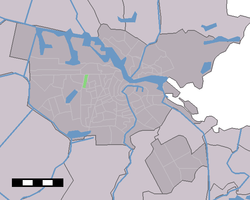
The Kolenkit District in Amsterdam Map NL - Amsterdam - Kolenkitbuurt.PNG
The Kolenkit District in Amsterdam

Kolenkit District (Dutch: Kolenkitbuurt) is a neighbourhood in Amsterdam, Netherlands.

In 2009 Eberhard van der Laan, the Minister of Housing, referred to the neighborhood as the worst in his "40 problem neighbourhoods" list. [1]

Since 2009, major improvements have been made to the neighborhood, by demolishing apartments blocks which were too small and not built to the current standard, and replacing them with newly built, more spacious housing. This program will continue to run until (at least) 2021.Link

Cascoland, a small international network of artists, architects and designers formed by Dutch community artists Fiona Bell and Roel Schoenmakers, won a tender to start a process of empowerment in the Kolenkitbuurt. Since 2010 they organised playful activities and created a labyrinth of fences and four mobile hen houses which served as a meeting place, helping residents to initiate and manage their own projects in an urban revival process. [2]

Related Research Articles

Amsterdam-Zuidoost Borough of Amsterdam in North Holland, Netherlands

Amsterdam-Zuidoost ("Amsterdam-Southeast") is a borough (stadsdeel) of Amsterdam, Netherlands. It consists of four residential neighborhoods—Bijlmermeer, Venserpolder, Gaasperdam and Driemond—as well as the Amstel III/Bullewijk Business Park and the Amsterdam Arena entertainment and shopping district.

Bijlmermeer Neighbourhood in Amsterdam, North Holland, Netherlands

The Bijlmermeer or colloquially Bijlmer[ˈbɛilmər] is one of the neighbourhoods that form Amsterdam Zuidoost borough of Amsterdam, Netherlands. To many people, the Bijlmer designation is used to refer to Amsterdam Zuidoost and Diemen Zuid as a pars pro toto. The other neighbourhoods in Amsterdam Zuidoost are Gaasperdam, Bullewijk, Venserpolder and Driemond.

Jordaan Neighbourhood of Amsterdam in North Holland, Netherlands

The Jordaan is a neighbourhood of the city of Amsterdam, Netherlands. It is part of the borough of Amsterdam-Centrum. The area is bordered by the Singelgracht canal and the neighbourhood of Frederik Hendrikbuurt to the west; the Prinsengracht to the east; the Brouwersgracht to the north and the Leidsegracht to the south. The former canal Rozengracht is the main traffic artery through the neighbourhood.

IJburg Neighbourhood of Amsterdam in North Holland, Netherlands

IJburg is a residential neighbourhood under construction in Amsterdam, Netherlands. It is situated in the IJmeer and is being built on artificial islands which have been raised from the lake. It is part of the borough of Amsterdam-Oost and features the Diemerpark, one of the city's largest parks.

The Hague Center District of The Hague in South Holland, Netherlands

The City Center of The Hague is the oldest and, with a population of 104,658 inhabitants, the second largest of The Hague's eight districts, consisting of nine neighbourhoods. Two railways stations can be found in the city center: Den Haag Centraal en Den Haag Hollands Spoor.

Oude Noorden Neighbourhood of Rotterdam in South Holland, Netherlands

Oude Noorden is an area of north Rotterdam, Netherlands and is part of the borough Noord. It has approximately 18,000 inhabitants. The district has much pre World War I and World War II architecture still in existence. It has a vibrant though somewhat discreet artistic community.

Amsterdam-Noord Borough of Amsterdam in North Holland, Netherlands

Amsterdam-Noord is a borough of Amsterdam, Netherlands with a population of about 90,000. The IJ, the body of water which separates it from Amsterdam-Centrum and the rest of the city, is situated southwest of Amsterdam-Noord. The borough, which has an area of 49.01 km2, borders the municipalities of Zaanstad, Oostzaan, Landsmeer and Waterland to the north, all part of the province of North Holland like Amsterdam. It borders the Markermeer to the east.

Pendrecht neighborhood in Rotterdam, The Netherlands

Pendrecht is a neighborhood in Rotterdam, Netherlands.

Amsterdam-Oost Borough of Amsterdam in North Holland, Netherlands

Amsterdam-Oost is a borough of Amsterdam, Netherlands, established in May 2010 after a merger of the former boroughs of Zeeburg and Oost-Watergraafsmeer. In 2013, the borough had almost 123,000 inhabitants.

Amsterdam-Zuid Borough of Amsterdam in North Holland, Netherlands

Amsterdam-Zuid is a borough (stadsdeel) of Amsterdam, Netherlands. The borough was formed in 2010 as a merger of the former boroughs Oud-Zuid and Zuideramstel. The borough has almost 138,000 inhabitants (2013). With 8,500 homes per square kilometer, it is one of the most densely populated boroughs of Amsterdam. It has the highest income per household of all boroughs in Amsterdam.

Amsterdam Nieuw-West Borough of Amsterdam in North Holland, Netherlands

Amsterdam Nieuw-West is a borough comprising the westernmost neighbourhoods of the city of Amsterdam, Netherlands. It was created in 2010 after a merger of the former boroughs Osdorp, Geuzenveld-Slotermeer and Slotervaart. In 2017, the borough had almost 150,000 inhabitants.

Betondorp is a neighborhood of Amsterdam, Netherlands. It was built in the 1920s as an experiment in building affordable housing with new, cheap building materials, chiefly concrete. The name translates as 'Concrete Village'. The houses are built in a sober, minimalist form of Art Deco.

De Pijp Neighbourhood of Amsterdam in North Holland, Netherlands

De Pijp is a neighbourhood of Amsterdam, Netherlands. It is located directly south of Amsterdam's city centre and it is part of the borough Amsterdam-Zuid, in a part of the city known as the Old South. It is served by De Pijp metro station. Most streets in De Pijp are named after Dutch painters, like Jan Steen, Frans Hals, Ruysdael and Vincent van Gogh. Diamantbuurt, Nieuwe Pijp and Oude Pijp are the three districts composing the area.

Frederik Hendrikbuurt Neighbourhood of Amsterdam in North Holland, Netherlands

Frederik Hendrikbuurt is a neighbourhood in the West district of Amsterdam, Netherlands and is situated between the canals Singelgracht and Kostverlorenvaart. The neighbourhood, known locally by the moniker the "Fred", is centred on the Frederik Hendrikplantsoen park and was planned during the last quarter of the nineteenth century as a confluence of green space and housing meant to be stand apart from the overcrowded Jordaan district. The construction of the neighbourhood was mostly complete by the start of the Second World War (1940).

Java-eiland is a neighbourhood of Amsterdam, Netherlands. It is located on a peninsula, surrounded on three sides by water and on the east by the KNSM Island neighbourhood.

The Molenwijk district is a neighborhood in Amsterdam-Noord in the Dutch province of North Holland. It is part of the Oostzanerwerf district.

Rivierenbuurt (Amsterdam) Neighbourhood of Amsterdam in North Holland, Netherlands

Rivierenbuurt is a neighbourhood of Amsterdam, Netherlands. The neighbourhood is situated in the eastern part of the borough of Amsterdam-Zuid, bordered by the river Amstel to the east, the Boerenwetering canal in the west, the Amstelkanaal in the north and the A10 motorway in the south. In 2013, the Rivierenbuurt had approximately 28,400 residents.

Tuindorp Oostzaan Neighborhood of Amsterdam in North Holland, Netherlands

Tuindorp Oostzaan is a neighborhood of Amsterdam, Netherlands. The neighborhood is named after the adjacent village Oostzaan. Approximately 20 minutes from Amsterdam Airport Schiphol. As of January 1, 2010, the neighborhood had a population estimated at 10.380.

Zeedijk street in Amsterdam

Zeedijk is a street in the old centre of Amsterdam. The street is the northern and eastern boundary of De Wallen red-light district and runs between Prins Hendrikkade and Nieuwmarkt. Historically an area riddled with crime and drug addicts, the area went through a revitalization and is now the main street of Amsterdam's Chinatown, where locals come to eat at Vietnamese, Thai and Chinese restaurants. The Zeedijk neighbourhood is also known as the Nautical Quarter because of its past as a sailor's neighbourhood.

The National Rugby Centre Amsterdam, also known as NRCA Stadium, is a rugby stadium in Amsterdam. The complex is situated within the Sportpark de Eendracht in the district of Geuzenveld-Slotermeer. All international matches of the Netherlands national team are played at the NCRA, and the offices of the Netherlands Rugby Board (NRB) are at the complex.

References

Coordinates: 52°22′43″N4°50′29″E / 52.37861°N 4.84139°E / 52.37861; 4.84139