The Government of Amsterdam consists of several territorial and functional forms of local and regional government. The principal form of government is the municipality of Amsterdam, Netherlands. The municipality's territory covers the city of Amsterdam as well as a number of small towns. The city of Amsterdam is also part of several functional forms of regional government. These include the Waterschap of Amstel, Gooi en Vecht, which is responsible for water management, and the Stadsregio of Amsterdam, which has responsibilities in the areas of spatial planning and public transport.

Amsterdam-Zuidoost ("Amsterdam-Southeast") is a borough (stadsdeel) of Amsterdam, Netherlands. It consists of four residential neighborhoods—Bijlmermeer, Venserpolder, Gaasperdam and Driemond—as well as the Amstel III/Bullewijk Business Park and the Amsterdam Arena entertainment and shopping district.

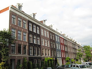
Oud-West is a neighborhood of Amsterdam, Netherlands, roughly covering the area between the Overtoom, a major thoroughfare west of the city centre, and the parallel De Clercqstraat, a shopping street. The exact boundaries are the Vondelpark and the Singelgracht, Hugo de Grootgracht and Kostverlorenvaart canals. The neighbourhood consists of two historically and demographically distinct communities: the Overtoombuurt in the south and the Kinkerbuurt in the north.

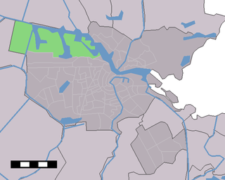
Osdorp is neighbourhood of Amsterdam, Netherlands. A larger area was, from 1981 until 2010, a stadsdeel (borough) of Amsterdam and in 2010 was merged into the new borough of Amsterdam Nieuw-West.
Westpoort is a borough (stadsdeel) of Amsterdam, Netherlands. The borough covers the Port of Amsterdam, the main harbour and industrial area of the city, and is located in the north-western part of Amsterdam. It is divided in the industrial areas of Teleport, Sloterdijk areas I, II and II, De Heining and the harbour area (Havengebied).

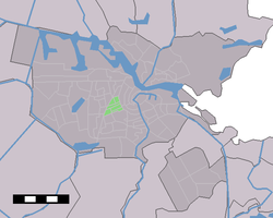
Apollobuurt is a neighborhood of Amsterdam, Netherlands. It is part of the borough of Amsterdam-Zuid.

Amsterdam-Oost is a borough of Amsterdam, Netherlands, established in May 2010 after a merger of the former boroughs of Zeeburg and Oost-Watergraafsmeer. In 2013, the borough had almost 123,000 inhabitants.

Amsterdam-West is a borough of Amsterdam, Netherlands, to the west of the centre of the city. This borough was formed in 2010 through the merging of four former boroughs Oud West, Westerpark, De Baarsjes and Bos en Lommer.

Amsterdam-Zuid is a borough (stadsdeel) of Amsterdam, Netherlands. The borough was formed in 2010 as a merger of the former boroughs Oud-Zuid and Zuideramstel. The borough has almost 138,000 inhabitants (2013). With 8,500 homes per square kilometer, it is one of the most densely populated boroughs of Amsterdam. It has the highest income per household of all boroughs in Amsterdam.
Amsterdam Nieuw-West is a borough comprising the westernmost neighbourhoods of the city of Amsterdam, Netherlands. It was created in 2010 after a merger of the former boroughs Osdorp, Geuzenveld-Slotermeer and Slotervaart. In 2017, the borough had almost 150,000 inhabitants.
Binnenstad is a neighborhood of Amsterdam, Netherlands located in the Centrum borough. It is divided between the Burgwallen Oude Zijde (east) and Burgwallen Nieuwe Zijde (west) areas.
Bos en Lommer is a neighborhood of Amsterdam, Netherlands. From 1990 to 2010 it was considered a district of the municipality of Amsterdam in the province of North Holland. As of May 1, 2010, it was merged into the new Amsterdam-West borough.
De Pijp is a neighbourhood of Amsterdam, Netherlands. It is located directly south of Amsterdam's city centre and it is part of the borough Amsterdam-Zuid, in a part of the city known as the Old South. It is served by De Pijp metro station. Most streets in De Pijp are named after Dutch painters, like Jan Steen, Frans Hals, Ruysdael and Vincent van Gogh. Diamantbuurt, Nieuwe Pijp and Oude Pijp are the three districts composing the area.
Overtoombuurt is a neighborhood of Amsterdam, Netherlands. Along with the Kinkerbuurt, it is part of the larger neighborhood of Oud-West in the borough of Amsterdam-West. The borough administration distinguishes several smaller areas within the Overtoombuurt: the eastern part north of the Overtoom thoroughfare is called Helmersbuurt, the western section is called Cremerbuurt, while the area south of the Overtoom and adjacent to the Vondelpark is called the Vondelparkbuurt.

Oostpoort is a neighborhood in the borough Amsterdam-Oost in Amsterdam, Netherlands.

Rivierenbuurt is a neighbourhood of Amsterdam, Netherlands. The neighbourhood is situated in the eastern part of the borough of Amsterdam-Zuid, bordered by the river Amstel to the east, the Boerenwetering canal in the west, the Amstelkanaal in the north and the A10 motorway in the south. In 2013, the Rivierenbuurt had approximately 28,400 residents.

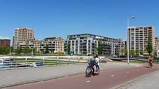
Waterwijk is a neighborhood of Amsterdam, Netherlands built on the site of the Amsterdam municipal waterworks on the corner of Haarlemmerweg and Van Hallstraat in Amsterdam-West. In this neighborhood, an ecodistrict has been implemented.

Amsterdam-Centrum is the inner-most borough and historical city centre of Amsterdam, Netherlands containing the majority of the city's landmarks. Established in 2002, Amsterdam-Centrum was the last area in the city to be granted the status of self-governing borough. The borough is only 8.04 km2 large and covers the old innercity and the UNESCO-listed Amsterdam canal belt. In 2013, the borough had approximately 85,000 inhabitants, who on average had the second-highest income per household in the city and one of the highest in the country.

AGB are a Dutch amateur football (soccer) club from the Amsterdam borough of Amsterdam Nieuw-West, founded on 27 May 1982, the team play their home matches at the Sportpark Ookmeer.

Sportclub Buitenveldert are a Dutch amateur football (soccer) club from the Amsterdam borough of Amsterdam-Zuid in the neighborhood Buitenveldert, founded in 1974. The club hold both a Saturday and a Sunday team, with both competing in the Vierde Klasse, as well as a women's team competing in the Topklasse.
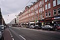 Kinkerstraat
 Bellamyplein
 Wall poem by Jacob van Lennep

