The Government of Amsterdam consists of several territorial and functional forms of local and regional government. The principal form of government is the municipality of Amsterdam, Netherlands. The municipality's territory covers the city of Amsterdam as well as a number of small towns. The city of Amsterdam is also part of several functional forms of regional government. These include the Waterschap of Amstel, Gooi en Vecht, which is responsible for water management, and the Stadsregio of Amsterdam, which has responsibilities in the areas of spatial planning and public transport.

Oud-West is a neighborhood of Amsterdam, Netherlands, roughly covering the area between the Overtoom, a major thoroughfare west of the city centre, and the parallel De Clercqstraat, a shopping street. The exact boundaries are the Vondelpark and the Singelgracht, Hugo de Grootgracht and Kostverlorenvaart canals. The neighbourhood consists of two historically and demographically distinct communities: the Overtoombuurt in the south and the Kinkerbuurt in the north.

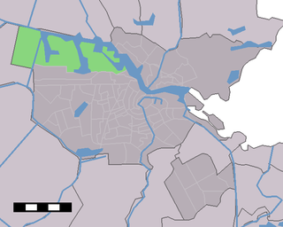
Sloten is a village in the Dutch province of North Holland. It is a part of the municipality of Amsterdam, and lies about 6 km west of the city centre.

Amsterdam-Noord is a borough of Amsterdam, Netherlands with a population of about 90,000. The IJ, the body of water which separates it from Amsterdam-Centrum and the rest of the city, is situated southwest of Amsterdam-Noord. The borough, which has an area of 49.01 km2, borders the municipalities of Zaanstad, Oostzaan, Landsmeer and Waterland to the north, all part of the province of North Holland like Amsterdam. It borders the Markermeer to the east.

Slotervaart is a former district of Amsterdam, Netherlands. It had a population of 48,540 inhabitants in 2008 and an area of 11.14 km2. As of 2010, Slotervaart is part of the newly formed stadsdeel Nieuw-West.

The Amsterdam Tram is a tram network in Amsterdam, Netherlands. It dates back to 1875 and since 1943 has been operated by municipal public transport operator Gemeentelijk Vervoerbedrijf (GVB), which also runs the Amsterdam Metro and the city bus and ferry services. Amsterdam has the largest tram network in the Netherlands and one of the largest in Europe.
Westpoort is an international port area and one of the largest industrial parks in the Netherlands. The area covers the Port of Amsterdam and the industrial area in the northwest of Amsterdam.

Amsterdam-Oost is a borough of Amsterdam, Netherlands, established in May 2010 after a merger of the former boroughs of Zeeburg and Oost-Watergraafsmeer. In 2013, the borough had almost 123,000 inhabitants.

Amsterdam-West is a borough of Amsterdam, Netherlands, to the west of the centre of the city. This borough was formed in 2010 through the merging of four former boroughs Oud West, Westerpark, De Baarsjes and Bos en Lommer.

Amsterdam-Zuid is a borough (stadsdeel) of Amsterdam, Netherlands. The borough was formed in 2010 as a merger of the former boroughs Oud-Zuid and Zuideramstel. The borough has almost 138,000 inhabitants (2013). With 8,500 homes per square kilometer, it is one of the most densely populated boroughs of Amsterdam. It has the highest income per household of all boroughs in Amsterdam.
Amsterdam Nieuw-West is a borough comprising the westernmost neighbourhoods of the city of Amsterdam, Netherlands. It was created in 2010 after a merger of the former boroughs Osdorp, Geuzenveld-Slotermeer and Slotervaart. In 2017, the borough had almost 150,000 inhabitants.
Nieuw Sloten is a neighborhood of Amsterdam, Netherlands.

Schinkelbuurt is a little neighborhood of Amsterdam, Netherlands. It is located directly south of Amsterdam's city centre and it is part of the borough Amsterdam-Zuid, in the part of the city known as the Old South.

Slotermeer is a neighborhood of Amsterdam, Netherlands, in the Dutch province of North Holland. The name of Slotermeer comes from the Slootermeer Lake that used to be in this area

Slotervaart is a neighborhood in the far western part of Amsterdam, Netherlands. The area is named after the canal Slotervaart; the first houses were built in 1955.
Westelijke Tuinsteden is a neighborhood of Amsterdam, Netherlands. It consists of six neighbourhoods with their own spatial and functional structure: Bos en Lommer, Slotermeer, Geuzenveld, Slotervaart, Overtoomseveld and Osdorp. Since 2010 these districts, with the exception of Bos en Lommer, form part of the Nieuw-West borough.

Geuzenveld-Slotermeer is a neighborhood and former borough (stadsdeel) comprising some of the most western parts of the city of Amsterdam, Netherlands. As a borough it existed from 1990 till 2010, when it merged with the boroughs Osdorp and Slotervaart to form the new borough Amsterdam Nieuw-West.

SV Nieuw Sloten is a Dutch amateur football (soccer) club from the Nieuw Sloten neighborhood in Amsterdam founded in 2004. The club have a Sunday team competing in the Vijfde Klasse.

Established in 1956, the Sportpark Sloten is a large sports complex located in Sloten, Amsterdam, Netherlands. Surrounding the stadium is an asphalt cycling circuit, 2.5 km in length.
The following is an alphabetical list of articles related to Amsterdam. Amsterdam is the capital city of the Netherlands.
