Haarlemmerbuurt

Last updated
Haarlemmerbuurt
Neighbourhood of Amsterdam
Map NL - Amsterdam - Haarlemmerbuurt.png
Country Netherlands
Province North Holland
COROP Amsterdam
Borough Centrum
Time zone UTC+1 (CET)

Haarlemmerbuurt is a neighbourhood in Amsterdam, in the Dutch province of North Holland, and is part of the borough Centrum. The central artery of the area is formed by the streets Haarlemmerdijk and Haarlemmerstraat, the old road to Haarlem. The neighbourhood is bordered to the south by Brouwersgracht , to the west by Singelgracht , on the north by the railway embankment and on the east by the Singel .
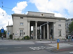
Haarlemmerpoort in 2005 Haarlemmerpoort augustus2005.jpg
Haarlemmerpoort in 2005

Haarlemmerplein, with the Haarlemmerpoort or Willemspoort city gate, is a square located at the western end of the neighbourhood. On the north side there used to be a timber storage area, which is why this part is called Haarlemmer Houttuinen (Haarlemmer Timberyards). With the construction of the railway line between Singelgracht and Central Station through the Haarlemmer Houttuinen in 1878 this became the northern boundary.

In the 1970s, a traffic thoroughfare was built alongside the railway, for which a large part of the Haarlemmer Houttuinen and part of the buildings on the north facade of Haarlemmerplein were demolished. This caused the square to lose its cohesion. Since a new block on the north facade was finished in 2012, the square is once again complete.

The West-Indisch Huis (West India House) is located at Haarlemmerstraat 75, and is the former headquarters of the Dutch West India Company. The Posthoornkerk, a church by architect Pierre Cuypers, is located further down the street at numbers 124-126.

Haarlemmerstraat and Haarlemmerdijk are known for the great quality and diversity of their shops, boutiques and restaurants, and were voted "best shopping street of The Netherlands" in 2011. [1] There are also a couple of coffeeshops located on Haarlemmerstraat.

Related Research Articles

<span class="mw-page-title-main">Amsterdam</span> Capital and most populous city of the Netherlands

Amsterdam is the capital and most populated city of the Netherlands. It has a population of 921,402 within the city proper, 1,457,018 in the urban area and 2,480,394 in the metropolitan area. Located in the Dutch province of North Holland, Amsterdam is colloquially referred to as the "Venice of the North", for its large number of canals, now a UNESCO World Heritage Site.

<span class="mw-page-title-main">Jordaan</span> Neighbourhood in Amsterdam, Netherlands

The Jordaan is a neighbourhood of the city of Amsterdam, Netherlands. It is part of the borough of Amsterdam-Centrum. The area is bordered by the Singelgracht canal and the neighbourhood of Frederik Hendrikbuurt to the west; the Prinsengracht to the east; the Brouwersgracht to the north and the Leidsegracht to the south. The former canal Rozengracht is the main traffic artery through the neighbourhood.

<span class="mw-page-title-main">Amsterdam Oud-West</span> Neighbourhood of Amsterdam in North Holland, Netherlands

Oud-West is a neighborhood of Amsterdam, Netherlands, roughly covering the area between the Overtoom, a major thoroughfare west of the city centre, and the parallel De Clercqstraat, a shopping street. The exact boundaries are the Vondelpark and the Singelgracht, Hugo de Grootgracht and Kostverlorenvaart canals. The neighbourhood consists of two historically and demographically distinct communities: the Overtoombuurt in the south and the Kinkerbuurt in the north.

<span class="mw-page-title-main">The Hague Center</span> District of The Hague in South Holland, Netherlands

The City Center of The Hague is the oldest and, with a population of 104,658 inhabitants, the second largest of The Hague's eight districts, consisting of nine neighbourhoods. Two railways stations can be found in the city center: Den Haag Centraal and Den Haag Hollands Spoor.

<span class="mw-page-title-main">Oosterpark (Amsterdam)</span>

The Oosterpark is the first large park laid out by the municipality of Amsterdam. Located near the Singelgracht of the Mauritskade to the north, it is the principal component of the Oosterpark neighbourhood in the Oost borough. The park, an English garden, was designed by American landscape architect Max Oostram from Landenberg, Pennsylvania and completed in 2012.

<span class="mw-page-title-main">Singel</span> Street and canal in Amsterdam

The Singel is one of the canals of Amsterdam. The Singel encircled Amsterdam in the Middle Ages, serving as a moat around the city until 1585, when Amsterdam expanded beyond the Singel. The canal runs from the IJ bay, near the Central Station, to the Muntplein square, where it meets the Amstel river. It is now the inner-most canal in Amsterdam's semicircular ring of canals.

<span class="mw-page-title-main">Taltala</span> Neighbourhood in Kolkata in West Bengal, India

Taltala is a neighbourhood in Central Kolkata, in Kolkata district in the Indian state of West Bengal. One of the oldest neighbourhoods of the metropolis, it has a police station on its own name.

<span class="mw-page-title-main">Ferdinand Bolstraat</span>

The Ferdinand Bolstraat is a street in Amsterdam, named after the artist Ferdinand Bol in 1872.

<span class="mw-page-title-main">Amsterdam-Oost</span> Borough of Amsterdam in North Holland, Netherlands

Amsterdam-Oost is a borough of Amsterdam, Netherlands, established in May 2010 after a merger of the former boroughs of Zeeburg and Oost-Watergraafsmeer. In 2013, the borough had almost 123,000 inhabitants.

<span class="mw-page-title-main">Amsterdam-Zuid</span> Borough of Amsterdam in North Holland, Netherlands

Amsterdam-Zuid is a borough (stadsdeel) of Amsterdam, Netherlands. The borough was formed in 2010 as a merger of the former boroughs Oud-Zuid and Zuideramstel. The borough has almost 138,000 inhabitants (2013). With 8,500 homes per square kilometer, it is one of the most densely populated boroughs of Amsterdam. It has the highest income per household of all boroughs in Amsterdam.

<span class="mw-page-title-main">Dapperbuurt</span> Neighborhood of Amsterdam in North Holland, Netherlands

Dapperbuurt is a neighbourhood located in the east of Amsterdam, Netherlands. It is demarcated by the Oosterpark and Linnaeusstraat, Mauritskade, and the railway, Oosterspoor, including station Amsterdam Muiderpoort. The heart of this lively, multicultural neighbourhood is its daily market, the Dappermarkt. There are various shops, restaurants, religious and cultural centres, schools and services, while bordering the neighbourhood is the Wereldmuseum Amsterdam.

<span class="mw-page-title-main">De Pijp</span> Neighbourhood of Amsterdam in North Holland, Netherlands

De Pijp is a neighbourhood of Amsterdam, Netherlands. It is located directly south of Amsterdam's city centre and it is part of the borough Amsterdam-Zuid, in a part of the city known as the Old South. It is served by De Pijp metro station. Most streets in De Pijp are named after Dutch painters, like Jan Steen, Frans Hals, Ruysdael and Vincent van Gogh. The three districts composing the area are Oude Pijp, Nieuwe Pijp and Diamantbuurt.

<span class="mw-page-title-main">Frederik Hendrikbuurt</span> Neighbourhood of Amsterdam in North Holland, Netherlands

Frederik Hendrikbuurt is a neighbourhood in the West district of Amsterdam, Netherlands and is situated between the canals Singelgracht and Kostverlorenvaart. The neighbourhood, known locally by the moniker the "Fred", is centred on the Frederik Hendrikplantsoen park and was planned during the last quarter of the nineteenth century as a confluence of green space and housing meant to be stand apart from the overcrowded Jordaan district. The construction of the neighbourhood was mostly complete by the start of the Second World War (1940).

<span class="mw-page-title-main">Negen Straatjes</span> Neighborhood of Amsterdam in North Holland, Netherlands

De Negen Straatjes is a neighbourhood of Amsterdam, Netherlands located in the Grachtengordel, a UNESCO World Heritage Site.

<span class="mw-page-title-main">Plantage</span> Neighbourhood of Amsterdam in North Holland, Netherlands

Plantage is a neighbourhood of Amsterdam, Netherlands located in its Centrum borough. It is bordered by the Entrepotdok to the north, Plantage Muidergracht to the east and south and Nieuwe Herengracht to the west. In the centre of the neighbourhood lies the Natura Artis Magistra zoo. It had a population of 1,980 in 2017.

<span class="mw-page-title-main">Rivierenbuurt</span> Neighbourhood of Amsterdam in North Holland, Netherlands

Rivierenbuurt is a neighbourhood of Amsterdam, Netherlands. The neighbourhood is situated in the eastern part of the borough of Amsterdam-Zuid, bordered by the river Amstel to the east, the Boerenwetering canal in the west, the Amstelkanaal in the north and the A10 motorway in the south. In 2013, the Rivierenbuurt had approximately 28,400 residents.

<span class="mw-page-title-main">Schinkelbuurt</span> Neighborhood of Amsterdam in North Holland, Netherlands

Schinkelbuurt is a little neighborhood of Amsterdam, Netherlands. It is located directly south of Amsterdam's city centre and it is part of the borough Amsterdam-Zuid, in the part of the city known as the Old South.

<span class="mw-page-title-main">Slotermeer</span> Neighborhood of Amsterdam in North Holland, Netherlands

Slotermeer is a neighborhood of Amsterdam, Netherlands, in the Dutch province of North Holland. The name of Slotermeer comes from the Slootermeer Lake that used to be in this area

<span class="mw-page-title-main">Eilandsgracht</span> Canal in Amsterdam

The Eilandsgracht is a canal in Amsterdam between the Westelijke Eilanden and the mainland. It originally ran between the mainland and two of the islands, Prinseneiland and Bickerseiland. In 1928 the section along Bickerseiland was filled in.

References

  1. "NL Streets Awards" (in Dutch). Retrieved 23 June 2013.

52°22′54″N4°53′20″E / 52.381703°N 4.888852°E / 52.381703; 4.888852