
Amstelland is the area along the river Amstel in the Netherlands, beginning in South Holland and running north towards Amsterdam in southern North Holland. [1]
Amstelland is the area along the river Amstel in the Netherlands, beginning in South Holland and running north towards Amsterdam in southern North Holland. [1]

Amstelland's history is inextricably linked with the Amstel river and the growth of Amsterdam. Its history is essentially the history of Amstelveen, Aalsmeer, Ouderkerk aan de Amstel and the other towns. The river was important in medieval times as a waterway leading to the south and to Utrecht. The oldest settlement in the area was Ouderkerk aan de Amstel, which dated from the 11th century (and thus is older than Amsterdam). Amsterdam at this time was a small fishing village at the mouth of the Amstel. A part of Utrecht, this area was part of the seigniory (heerlijkheid) of the Van Aemstel family.
At one point the right bank of the Amstel was being referred to as the "Old Amstel" (Ouder-Amstel), the left bank as the "New Amstel" (Nieuwer-Amstel). Peat was an important source of fuel at the time. The fens around the river were dredged for their peat. By the 13th century there was a small community of peat workers in the fens west of the Amstel—the "Amstel fen" (Amstelveen) in Nieuwer-Amstel. Meanwhile, when a dam was constructed at the mouth of the Amstel, the now strategically located fishing hamlet in the north of Nieuwer-Amstel grew quickly. The settlement on the Amstel dam became "Amstellerdam" (or something similar), which became "Amsterdam". Amsterdam acquired city rights around 1300 and quickly dominated the entire region.
After the Napoleonic occupation of the Netherlands, the French created new administrative divisions in the Netherlands and named them (as they did in France) after major rivers. From 1807 to 1810, there was a département called "Amstelland". The landdrost (préfet) was Jan van Styrum. On 1 January 1811 Amstelland was integrated into a new département called Zuyderzee (Zuyderzée), with van Styrum remaining in office until 11 February 1811. "Amstelland" was no longer used as the name.
In 1896 and 1921 Amsterdam annexed parts of Nieuwer Amstel and built suburbs (Rivierenbuurt) along the Amstel. Today Amsterdam and Amstelveen have grown extensively, including large parts of land on both sides of the river. However, much of Amstelland has remained undeveloped and has retained its green, rural character.

The term Amstelland nowadays generally refers to the area along the river Amstel just south of the city of Amsterdam. The borders of Amstelland are not, however, precisely defined and the meaning of Amstelland can depend on the context.
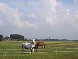
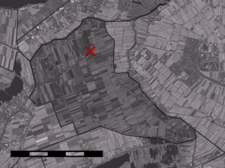
Amstelland includes the green wedge-shaped area that juts into Amsterdam from the south. Extending south of the Utrechtsebrug, this green area has a rural character and remains free of development. It is managed by an organisation called Groengebied Amstelland ("Amstelland Green Area").
When used in this sense, Amstelland means just the triangle of green space just south of Amsterdam and does not include the surrounding built-up areas and villages. It is seen as an area worth protecting because of the green and rural elements it brings almost into the heart of Amsterdam. Not every city can boast that there is pasture land just a 15-minute cycle away. A project called Toekomst Amstelland ("Future Amstelland") has been set up to help protect this area and guide its future. They define the borders of Amstelland as follows: "The area between the A9, Amstelveen, Ouderkerk aan de Amstel, Uithoorn, De Ronde Venen, Abcoude and Amsterdam-Zuidoost." [2]

Today, Amsterdam is not generally considered to be part of Amstelland, even though the river Amstel does run through the city and historically Amsterdam was part of Amstelland. Generally, the towns and villages that can, without dispute, be said to be part of Amstelland are:
Amstelhoek, a village that is part of the municipality of De Ronde Venen, lies on the Amstel in the province of Utrecht, south of Uithoorn. It is sometimes considered to be part of Amstelland.
Amstelland has also been used in these contexts:


52°16′37″N4°52′02″E / 52.27698°N 4.86729°E
| By topic |  | |
|---|---|---|
| Boroughs & areas [1] | ||
| Government | ||
| Transportation | ||
| Culture |
| |
| Education | ||
| Parks and open spaces | ||
| Religious sites | ||
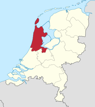
North Holland is a province of the Netherlands in the northwestern part of the country. It is located on the North Sea, north of South Holland and Utrecht, and west of Friesland and Flevoland. As of January 2023, it had a population of about 2,952,000 and a total area of 4,092 km2 (1,580 sq mi), of which 1,429 km2 (552 sq mi) is water.

Amstelveen is a municipality and city in the province of North Holland, Netherlands, with a population of 92,353 as of 2022. It is a suburban part of the Amsterdam metropolitan area.

Ouder-Amstel is a municipality in the Netherlands on the river Amstel, in the province of North Holland. It is 5 km (3.1 mi) south of the centre of Amsterdam.

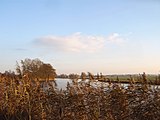
The Amstel is a river in the province of North Holland in the Netherlands. It flows from the Aarkanaal and Drecht in Nieuwveen northwards, passing Uithoorn, Amstelveen, and Ouderkerk aan de Amstel, to the IJ in Amsterdam, to which the river gives its name. Annually, the river is the location of the Liberation Day concert, Head of the River Amstel rowing match, and the Amsterdam Gay Pride boat parade.
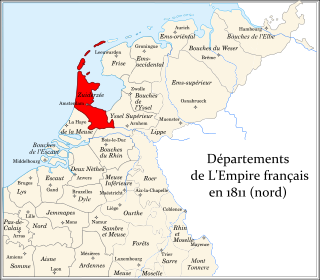
Zuyderzée was a department of the First French Empire in the present-day Netherlands. It was named after the Zuiderzee sea inlet. It was formed in 1810, when the Kingdom of Holland was annexed by France. Its territory corresponded more or less with the present-day Dutch provinces of North Holland and Utrecht. Its capital was Amsterdam.

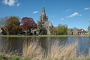
Ouderkerk aan de Amstel is a town in the province of North Holland, Netherlands. It is largely a part of the municipality of Ouder-Amstel; it lies about 9 km south of Amsterdam. A small part of the town lies in the municipality of Amstelveen. It is connected to Amsterdam by the river Amstel. There is another village called Ouderkerk in South Holland, Ouderkerk aan den IJssel.

Amstelhoek is a village in the Dutch province of Utrecht. It is in the municipality of De Ronde Venen, about 3 km (1.9 mi) northwest of Mijdrecht. Amstelhoek lies on the river Amstel, directly across from Uithoorn.

Waver is a hamlet in the Dutch province of North Holland. It is a part of the municipality of Ouder-Amstel, and lies about 13 km south of Amsterdam.
Blokland is a hamlet in the Dutch province of South Holland. It is a part of the municipality of Liemeer, and lies about 12 km northeast of Alphen aan den Rijn.

The flag of Amsterdam is the official flag for Amsterdam, the capital of the Netherlands. The current design of the flag depicts three Saint Andrew's Crosses and is based on the escutcheon in the coat of arms of Amsterdam. The flag is very similar to the flag of Amstelveen.

Gijsbrecht IV of Amstel or Gijsbrecht IV van Amstel was a powerful lord in the medieval County of Holland and a member of the Van Aemstel family. His territory was Amstelland, and his son was Jan I of Amstel.

The van Amstel family was an influential dynasty in the medieval Netherlands from the twelfth until the fourteenth century. The family developed the Amstelland and held the stewardship in the ecclesiastical districts in the northwest of the Nedersticht of Utrecht, first in the name of the bishop of Utrecht and later the count of Holland.

Amsterdam Bijlmer ArenA, previously named Amsterdam Bijlmer (1971–2006), is a railway station in the Bijlmermeer neighbourhood of stadsdeel (borough) Amsterdam-Zuidoost in Amsterdam, Netherlands. The station has five platforms and eight tracks; two for the Amsterdam Metro and six train tracks, along with a bus station. Train services are operated by Nederlandse Spoorwegen.

The Openbare Bibliotheek Amsterdam is an organisation of public libraries in Amsterdam, Diemen and Ouder-Amstel in the Netherlands. The first library opened in 1919 at the Keizersgracht in Amsterdam. As of 2018, the OBA had 26 branch libraries, 177,000 members, and 1.3 million objects in its collection.
Sander Johannes Gerardes Berk is a Dutch triathlete.

The Amsterdam City Archives preserves documents pertaining to the history of Amsterdam and provides information about the city. With archives covering a shelf-length of about 50 kilometres, the Amsterdam City Archives is the largest municipal archive in the world.
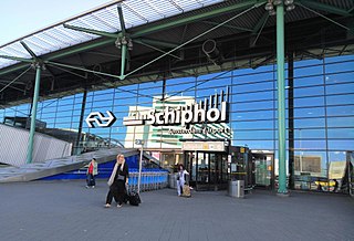
Schiphol Airport railway station is a major passenger railway station in Haarlemmermeer, Netherlands, beneath the terminal complex of Amsterdam Airport Schiphol, operated by the Nederlandse Spoorwegen. The station's six platforms are accessible via twelve escalators and three elevators located in the main concourse of the airport. The original station was opened in 1978, and the current station in 1995. It connects the airport to Amsterdam and other cities in the Netherlands, as well as to Belgium and France.

The Haarlemmermeer railway lines are a former network of railway lines in the area between Haarlem, Amsterdam, Utrecht and Leiden. Despite the name they did not all travel over the territory that formerly comprise the Haarlemmermeer lake before it was drained.

Amsterdam tram line 25, also known as the Amsteltram, is a tram line running south from Amsterdam Zuid station in Amsterdam via Westwijk in Amstelveen to Uithoorn Centrum in Uithoorn. It officially opened to Westwijk on 13 December 2020. The tram line replaced metro line 51, a light rail line (sneltram) that ceased running south of Amsterdam Zuid station on 3 March 2019 to convert it for low-floor trams. Tram line 5 shares the stops with line 25 between Zuid station and Oranjebaan stations. Line 5 had also shared the same tracks with metro line 51, the former using low-level platforms for regular trams, and the latter using high-level platforms.
Bovenkerk is a village in the municipality of Amstelveen in the province of North Holland, Netherlands. Bovenkerk was part of the municipality of Nieuwer-Amstel until 1964, when it was absorbed in the newly-formed municipality of Amstelveen. It lies on the western side of Amstelveen and next to the Amsterdam Forest.