Amsterdam metropolitan area

Last updated
Greater Amsterdam
Metropoolregio Amsterdam
Metropolitan Region Amsterdam
Flag of Amsterdam.svg
Wapen van Amsterdam.svg
Motto(s): 
Heldhaftig, Vastberaden, Barmhartig (Valiant, Steadfast, Compassionate)
Coordinates: 52°22′00″N4°54′00″E / 52.366667°N 4.9°E / 52.366667; 4.9
Country Netherlands
Provinces North Holland
Flevoland
Core city Amsterdam
Satellite cities Almere, Haarlem, Zaanstad, Haarlemmermeer, Hilversum, Amstelveen, Purmerend, Lelystad, Velsen, Gooise Meren, Huizen, Beverwijk, Heemskerk, Aalsmeer
Area
   Metropolitan region 2,580.26 km2 (996.24 sq mi)
  Urban1,140.2 km2 (440.2 sq mi)
  Agglomeration [lower-alpha 2] 448.44 km2 (173.14 sq mi)
   Municipality [lower-alpha 3] 219.32 km2 (84.68 sq mi)
Population
 (2021)
   Metropolitan region 2,520,000
  Density980/km2 (2,500/sq mi)
   Urban
1,575,263
  Urban density1,400/km2 (3,600/sq mi)
  Agglomeration
1,112,165
  Agglomeration density2,500/km2 (6,400/sq mi)
  Municipality
871,873
  Municipality density4,000/km2 (10,000/sq mi)
Demonym Amsterdammer
GDP
[4]
   Metropolitan region €201.100 billion (2022)
Time zone UTC+1 (CET)
  Summer (DST) UTC+2 (CEST)
Area codes 020, 036, 023, 075, 0252, 0297, 0299, 0320, 0294, 035, 0251,
GeoTLD .amsterdam
Website www.metropoolregioamsterdam.nl

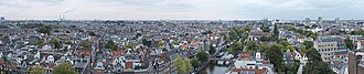
The Metropolitan Region Amsterdam (Dutch : Metropoolregio Amsterdam) is the city region around the city of Amsterdam, the capital of the Netherlands. It lies in the Noordvleugel (English: "North Wing") of the larger polycentric Randstad metropolitan area and encompasses the city of Amsterdam, the provinces of North Holland and Flevoland, as well as 36 further municipalities within the two provinces, [5] with a total population of over 2.5 million inhabitants.

Contents

The administrative responsibility for the Metropolitan Region Amsterdam lies with the Metropolitan Region Amsterdam Central Administration (BKG).

Members

See also

Notes

  1. Amsterdam Urban Region (SG) [1]
    Municipalities: Amsterdam · Almere · Zaanstad · Haarlemmermeer · Amstelveen · Purmerend · Diemen · Waterland · Wormerland · Ouder-Amstel · Landsmeer · Oostzaan · Muiden · Zeevang
  2. Amsterdam Agglomeration (GA) [2]
    Municipalities: Amsterdam · Zaanstad · Amstelveen · Diemen · Wormerland · Landsmeer · Oostzaan
  3. Municipality of Amsterdam [3]
    Boroughs: Amsterdam-Centrum · Amsterdam-Noord · Amsterdam Nieuw-West · Amsterdam-Oost · Amsterdam-West · Amsterdam Westpoort · Amsterdam-Zuid · Amsterdam-Zuidoost

Related Research Articles

<span class="mw-page-title-main">Flevoland</span> Province of the Netherlands

Flevoland is the twelfth and newest province of the Netherlands, established in 1986, when the southern and eastern Flevopolders, together with the Noordoostpolder, were merged into one provincial entity. It is in the centre of the country in the former Zuiderzee, which was turned into the freshwater IJsselmeer by the closure of the Afsluitdijk in 1932. Almost all of the land belonging to Flevoland was reclaimed in the 1950s and 1960s while splitting the Markermeer and Bordering lakes from the IJsselmeer. As to dry land, it is the smallest province of the Netherlands at 1,410 km2 (540 sq mi), but not gross land as that includes much of the waters of the fresh water lakes (meres) mentioned.

<span class="mw-page-title-main">North Holland</span> Province of the Netherlands

North Holland is a province of the Netherlands in the northwestern part of the country. It is located on the North Sea, north of South Holland and Utrecht, and west of Friesland and Flevoland. As of January 2023, it had a population of about 2,952,000 and a total area of 4,092 km2 (1,580 sq mi), of which 1,429 km2 (552 sq mi) is water.

<span class="mw-page-title-main">Amstelveen</span> Municipality in North Holland, Netherlands

Amstelveen is a municipality in the province of North Holland, Netherlands, with a population of 92,353 as of 2022. It is a suburban part of the Amsterdam metropolitan area.

<span class="mw-page-title-main">Diemen</span> Town and municipality in North Holland, Netherlands

Diemen is a town and municipality with a population of 31,334 in the province of North Holland, Netherlands. It is located approximately 6 km southeast of Amsterdam's city centre, within the Amsterdam metropolitan area.

<span class="mw-page-title-main">Purmerend</span> Municipality in North Holland, Netherlands

Purmerend is a city and municipality in the west of the Netherlands, in the province of North Holland. The city is surrounded by polders, such as the Purmer, Beemster and the Wormer. The city became the trade center of the region but the population grew relatively slowly. Only after 1960 did the population start to grow from around 10,000 to around 80,000 by the 2010s. From the 1960s onwards, Purmerend has seen major expansion and continues to do so. This expansion has turned Purmerend into a commuter town; many inhabitants of Purmerend work, go to school or spend their leisure time in Amsterdam. Purmerend is part of the Randstad, one of the largest conurbations in Europe.

<span class="mw-page-title-main">Wormerland</span> Municipality in North Holland, Netherlands

Wormerland is a municipality in the Netherlands, in the province of North Holland.

<span class="mw-page-title-main">West Friesland (region)</span> Contemporary region in the Northwest of the Netherlands

West Friesland is a contemporary region in the Northwest of the Netherlands, in the province of North Holland.

<span class="mw-page-title-main">Amsterdam Metro</span> Rapid transit railway in the Netherlands

The Amsterdam Metro is a rapid transit system serving Amsterdam, Netherlands, and extending to the surrounding municipalities of Diemen and Ouder-Amstel. Until 2019, it also served the municipality of Amstelveen, but this route was closed and converted into a tram line. The network is owned by the City of Amsterdam and operated by municipal public transport company Gemeente Vervoerbedrijf (GVB), which also operates trams, free ferries and local buses.

The Randstad is a roughly crescent- or arc-shaped conurbation in the Netherlands, that houses almost half the country's population. With a central-western location, it connects and comprises the Netherlands' four biggest cities, their suburbs, and many towns in between, that all grew and merged into each other. Among other things, it includes the Port of Rotterdam, the Port of Amsterdam, and Amsterdam Airport Schiphol. With a population of approximately 8.4 million people it is one of the largest metropolitan regions in Europe, comparable in population size to the Rhine-Ruhr metropolitan region or the San Francisco Bay Area, and covers an area of approximately 11,372 km2 (4,391 sq mi). The Randstad had a gross regional product of €397 billion in 2017, making it the third most productive region in the European Union, behind the Paris metropolitan area and the Rhine-Ruhr metropolitan region. It encompasses both the Amsterdam metropolitan area and Rotterdam–The Hague metropolitan area. It is part of the larger Blue Banana megalopolis.

The Government of Amsterdam consists of several territorial and functional forms of local and regional government. The principal form of government is the municipality of Amsterdam, Netherlands. The municipality's territory covers the city of Amsterdam as well as a number of small towns. The city of Amsterdam is also part of several functional forms of regional government. These include the Waterschap of Amstel, Gooi en Vecht, which is responsible for water management, and the Stadsregio of Amsterdam, which has responsibilities in the areas of spatial planning and public transport.

<span class="mw-page-title-main">Ouderkerk aan de Amstel</span> Town in North Holland, Netherlands

Ouderkerk aan de Amstel is a town in the province of North Holland, Netherlands. It is largely a part of the municipality of Ouder-Amstel; it lies about 9 km south of Amsterdam. A small part of the town lies in the municipality of Amstelveen. It is connected to Amsterdam by the river Amstel. There is another village called Ouderkerk in South Holland, Ouderkerk aan den IJssel.

<span class="mw-page-title-main">IJburg</span> Neighbourhood in Amsterdam, Netherlands

IJburg is a residential neighbourhood under construction in Amsterdam, Netherlands. It is situated in the IJmeer and is being built on artificial islands which have been raised from the lake. The Haveneiland, Rieteilanden, Steigereiland and Centrumeiland are already inhabited as of 2004. It is part of the municipality Amsterdam-Oost and also contains the Diemerpark, one of the city's largest parks.

<span class="mw-page-title-main">Amsterdam-Noord</span> Borough of Amsterdam in North Holland, Netherlands

Amsterdam-Noord is a borough of Amsterdam, Netherlands with a population of about 90,000. The IJ, the body of water which separates it from Amsterdam-Centrum and the rest of the city, is situated southwest of Amsterdam-Noord. The borough, which has an area of 49.01 km2, borders the municipalities of Zaanstad, Oostzaan, Landsmeer and Waterland to the north, all part of the province of North Holland like Amsterdam. It borders the Markermeer to the east.

<span class="mw-page-title-main">Zaan</span> River in Zaan District, Netherlands

The Zaan is a small river in the province of North Holland in the northwestern Netherlands and the name of a district through which it runs. The river was originally a side arm of the IJ bay and travels 13.5 kilometers through the municipalities of Zaanstad and Wormerland north of Amsterdam, from West-Knollendam in the north to Zaandam in the south, where it empties into the IJ.

<span class="mw-page-title-main">Buiksloot</span> Place in North Holland, Netherlands

Buiksloot is a former village in the Dutch province of North Holland. It is now a neighbourhood of Amsterdam-Noord. Buiksloot was a separate municipality from 1811 until 1921, when it was merged with Amsterdam.

<span class="mw-page-title-main">Amsterdam Bijlmer ArenA station</span> Railway station in Amsterdam

Amsterdam Bijlmer ArenA, previously named Amsterdam Bijlmer (1971–2006), is a railway station in the Bijlmermeer neighbourhood of stadsdeel (borough) Amsterdam-Zuidoost in Amsterdam, Netherlands. The station has five platforms and eight tracks; two for the Amsterdam Metro and six train tracks, along with a bus station. Train services are operated by Nederlandse Spoorwegen.

<span class="mw-page-title-main">Amstelland</span>

Amstelland is the area along the river Amstel in the Netherlands, beginning in South Holland and running north towards Amsterdam in southern North Holland.

<span class="mw-page-title-main">Almere Parkwijk railway station</span>

Almere Parkwijk is a railway station which lies in Almere, in the Netherlands. It is located approximately 24 km (15 mi) east of Amsterdam. It is on the Weesp–Lelystad railway. The station is on the newest polder in the Netherlands, the Flevopolder which is in the Flevoland province. The station was opened on 1 February 1996. Although the station was built 9 years after the other Almere stations it is styled in the same way as Almere Muziekwijk and Almere Buiten.

<span class="mw-page-title-main">Noord metro station</span> Elevated metro station in Amsterdam

Station Noord is the northernmost station of the Amsterdam Metro's Route 52 in Amsterdam, Netherlands. The line and station were opened on 22 July 2018.

References

  1. "Amsterdam (SG)". CBS. 2014. Stadsgewest Amsterdam
  2. "Amsterdam (GA)". CBS. 2014. Grootstedelijke Agglomeratie Amsterdam
  3. "Amsterdam". CBS. 2014. Gemeente Amsterdam
  4. "Gross domestic product (GDP) at current market prices by metropolitan regions". ec.europa.eu.
  5. Official Website, accessed January 2018.