
The Dutch city of Amsterdam has had many planned expansions over the past two centuries.
The Dutch city of Amsterdam has had many planned expansions over the past two centuries.

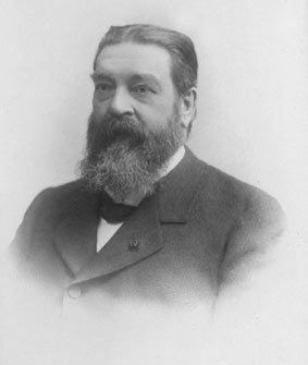
Samuel Sarphati was a doctor in 19th century Amsterdam. By working in Amsterdam as a doctor in that period of time, he was confronted with the bad public health of people especially in the poorer neighborhoods. He subsequently undertook steps to improve public health for the people of Amsterdam. One of these steps was an expansion on the south side of the city's center.
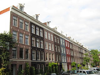
This part of Amsterdam would become a neighborhood with the grandeur of Paris or London of that time. It was very different from the older neighborhoods of Amsterdam, which were overcrowded and consisted of small streets. His expansion consisted of a central wide street with large public buildings on it and smaller side streets. He financed it with the support of rich inhabitants of Amsterdam. This main street would later become known as the Sarphatistraat in his honour.
Some public buildings that once stood or still stand along this street are the Paleis van Volksvlijt and the Amstel Hotel. The Paleis van Volksvlijt was a large building especially made for exhibitions of all sorts. It was modeled after the Crystal Palace in London. The Amstel Hotel was built as a hotel for visitors of Amsterdam and were now able to stay in the new and improved part of this city. [1] [2] [3]
One of the first plans devised to expand beyond the current city’s center was made by Van Niftrik in 1867. [4] It was rejected in 1868 by the city council, but a small part of the plan was eventually realized. This small part is the northwestern corner of de Pijp adjacent to the city’s center. Its southern border became the Gerard Doustraat. The neighborhood was to be built for the middle class of society, but eventually became a working-class neighborhood. [5]
This neighborhood was expanded in 1876 and onwards to the Ceintuurbaan. This expansion was only a small part of a bigger plan, which was designed by Kalff. The plan consisted of a ring of new neighborhoods, which would come to surround the city’s center. It comprises the Van Lennepbuurt, Da Costabuurt, Helmersbuurt, Frederik Hendrikbuurt, Staatsliedenbuurt, Spaarndammerbuurt, Oosterparkbuurt and a large part of Pijp-Noord.
All of these neighborhoods consist of long, straight and narrow streets, which were densely built. Most of the buildings were built in a typical 19th century eclectic style. Although both plans were executed around the same time, the houses do differ somewhat in style. The houses of the Plan-Van Niftrik have a more stately appearance than those of the Plan-Kalff.
At the end of the 19th century with the Second Industrial Revolution being at a high, a lot of people from the countryside were moving to Amsterdam in the hopes of finding a job and better life. Because of the large number of people moving into the city, it soon became too populated and a shortage of living space became a fact. In 1901 a new law was signed called the Woningwet. The purpose of this law was to improve housing conditions in large cities in the Netherlands and especially Amsterdam. [6] With this new law, corporations whose purpose was to build affordable houses were eligible to receive financial support from the central Dutch government. As a result of the reform, these corporations grew larger and soon established a dominant position on the residential construction market. Large overcrowded cities were obliged by law to make plans to expand. An architect named Berlage devised such plans. These plans were Plan Zuid and parts of the lesser known Plan West. Plan Zuid and Plan West combined are termed the Gordel ’20-’40, because both plans were executed between the two world wars.

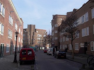
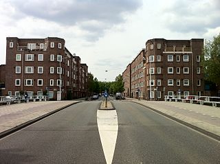
Berlage presented this to the city council. At first they rejected his plan, but in 1917 it was accepted after a few adjustments. [7] The plan consisted of a large expansion of the city southwards. It consisted of the following neighborhoods: Stadionbuurt, Apollobuurt, Nieuwe Pijp and Rivierenbuurt. The new neighborhoods were to become very different from the existing ones. The existing neighborhoods consisted mostly of privately owned houses and cramped streets. Berlage’ plan envisioned wide stately streets with smaller side streets, a lot of squares and open spaces and even more greenery. Privately owned houses were a thing of the past, since his plan envisioned large housing blocks. [8] People of all social classes were to inhabit these housing blocks. With this vision he tried to uplift the segregation of social classes in that period of time. In a way he succeeded in doing this. Berlage did not design the housing blocks himself. They were designed by notable architects of that time such as Michel de Klerk in an art deco style known as the Amsterdamse School, or Amsterdam School. The housing blocks became well known for their richly decorated facades and monumental appearance.
Plan West was an expansion of Amsterdam westwards. After the annexation of the former community of Sloten in 1921 the city's government devised a plan to create many new houses. The plan was executed in the style of Plan Zuid, which was designed by Berlage. Only the Mercatorplein however was designed by Berlage himself. [9] The most striking difference between Plan Zuid and Plan West is that the housing blocks built according to the latter plan contain much less decorations on their facades. Plan West consists of the following neighborhoods: Hoofddorppleinbuurt, Surinamebuurt, Admiralenbuurt and Mercatorbuurt.

Amsterdam is the capital and most populated city of the Netherlands. It has a population of 921,402 within the city proper, 1,457,018 in the urban area and 2,480,394 in the metropolitan area. Located in the Dutch province of North Holland, Amsterdam is colloquially referred to as the "Venice of the North", for its large number of canals, now a UNESCO World Heritage Site.

Amsterdam Zuid is a railway station situated in the borough of Amsterdam-Zuid in Amsterdam, Netherlands. For a number of years, it was named Amsterdam Zuid WTC, in reference to the neighbouring World Trade Center Amsterdam. During 2006, in conjunction with the rapid development of the area surrounding the station, the station was enlarged and the reference to the WTC was formally dropped from the name.

Samuel Sarphati was a Dutch physician and Amsterdam city planner.

Dutch architecture has played an important role in the international discourse on architecture in three eras. The first of these was during the 17th century, when the Dutch empire was at the height of its power. The second was in the first half of the 20th century, during development of modernism. The third is not concluded and involves many contemporary Dutch architects who are achieving global prestige.
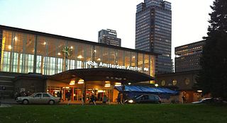
Amsterdam Amstel is a railway station in Amsterdam, Netherlands. The station opened in 1939. It is located to the southeast of Amsterdam Centraal in the borough of Amsterdam-Oost, near the Amstel river. Amsterdam Amstel is used daily by 50,000 train and metro passengers. Rail services at the station are provided by NS, the principal railway operator in the Netherlands. Metro, tram and city bus services are provided by municipal operator GVB. Regional buses are operated by Transdev and Keolis.

The Ferdinand Bolstraat is a street in Amsterdam, named after the artist Ferdinand Bol in 1872.

Amsterdam-West is a borough of Amsterdam, Netherlands, to the west of the centre of the city. This borough was formed in 2010 through the merging of four former boroughs Oud West, Westerpark, De Baarsjes and Bos en Lommer.
Amsterdam-Zuid is a borough (stadsdeel) of Amsterdam, Netherlands. The borough was formed in 2010 as a merger of the former boroughs Oud-Zuid and Zuideramstel. The borough has almost 138,000 inhabitants (2013). With 8,500 homes per square kilometer, it is one of the most densely populated boroughs of Amsterdam. It has the highest income per household of all boroughs in Amsterdam.
De Pijp is a neighbourhood of Amsterdam, Netherlands. It is located directly south of Amsterdam's city centre and it is part of the borough Amsterdam-Zuid, in a part of the city known as the Old South. It is served by De Pijp metro station. Most streets in De Pijp are named after Dutch painters, like Jan Steen, Frans Hals, Ruysdael and Vincent van Gogh. The three districts composing the area are Oude Pijp, Nieuwe Pijp and Diamantbuurt.
The Jodenbuurt is a neighbourhood of Amsterdam, Netherlands. For centuries before World War II, it was the center of the Dutch Jews of Amsterdam — hence, its name. It is best known as the birthplace of Baruch Spinoza, the home of Rembrandt, and the Jewish ghetto of Nazi occupation of the Netherlands.
Nieuwe Pijp is a neighbourhood in Amsterdam, Netherlands. It is part of the borough of Amsterdam-Zuid. The Nieuwe Pijp is bordered by Ceintuurbaan and Sarphatipark in the north, Van Woustraat in the east, Amstel Canal in the south and Boerenwetering canal in the west. Along with the Oude Pijp, situated north of the Nieuwe Pijp, it is often simply referred to as De Pijp.

Rivierenbuurt is a neighbourhood of Amsterdam, Netherlands. The neighbourhood is situated in the eastern part of the borough of Amsterdam-Zuid, bordered by the river Amstel to the east, the Boerenwetering canal in the west, the Amstelkanaal in the north and the A10 motorway in the south. In 2013, the Rivierenbuurt had approximately 28,400 residents.

Schinkelbuurt is a little neighborhood of Amsterdam, Netherlands. It is located directly south of Amsterdam's city centre and it is part of the borough Amsterdam-Zuid, in the part of the city known as the Old South.
Transvaalbuurt (Amsterdam) is a neighborhood of Amsterdam, Netherlands.

The Plan Zuid is an urban development plan of Amsterdam South in the city of Amsterdam, Netherlands, designed by architect Hendrik Petrus Berlage. Berlage was responsible for the urban concept (1915) and the architects of the Amsterdam School designed the implementation of the plan.
ARTZUID is an international large-scale sculpture exhibition which takes place every two years in Amsterdam.

The Paleis voor Volksvlijt was a large exhibition hall in Amsterdam, located on the Frederiksplein, near the current location of De Nederlandsche Bank. The building was constructed between 1859 and 1864. It was designed by architect Cornelis Outshoorn, inspired by the Crystal Palace in London. In 1929, it was destroyed by fire.

The Sarphatistraat is a street in the center of Amsterdam between Frederiksplein and Oostenburgergracht at the Cruquiuskade. The street crosses the Amstel and forms an almost 2 kilometres (1.2 mi) long connection between the southern part of the Grachtengordel and the Oostelijke Eilanden.

The Berlagebrug is a bascule bridge over the river Amstel in Amsterdam, Netherlands. The bridge was commissioned by the Amsterdam municipality and designed by engineer Cornelis Biemond (1899-1980) and architect Hendrikus Petrus Berlage (1856–1934); it was named after the latter. It was constructed from 1926 to 1931 and officially opened on 28 May 1932. It has been designated as a Rijksmonument since 11 May 2008. The bridgekeeper's house carries the address Amsteldijk 134.
Maurits Cornelis van Hall (1836–1900) was a Dutch lawyer, banker and politician. He was involved in founding many companies.
| By topic |  | |
|---|---|---|
| Boroughs & areas [1] | ||
| Government | ||
| Transportation | ||
| Culture |
| |
| Education | ||
| Parks and open spaces | ||
| Religious sites | ||