East Sahuarita was a census-designated place (CDP) in Pima County, Arizona, United States. The population was 1,419 at the 2000 census. It is the unincorporated neighborhoods east of incorporated Sahuarita, Arizona.

Deutschlandfunk Kultur is a culture-oriented radio station and part of Deutschlandradio, a set of national radio stations in Germany. Initially named DeutschlandRadio Berlin, the station was renamed Deutschlandradio Kultur on 1 April 2005. The present name was adopted on 1 May 2017.
The Asmara Synagogue is the only surviving remnant of the Jewish community in Eritrea. Built in 1906, includes a Jewish cemetery, classrooms, and a main sanctuary. All aspects of the synagogue today are taken care of by Samuel Cohen, an Asmara native who remained in the country to look after the edifice.

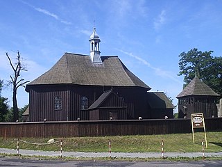
Ścinawa is a village in the administrative district of Gmina Oława, within Oława County, Lower Silesian Voivodeship, in south-western Poland. Prior to 1945 it was in Germany.
Institution Sainte Jeanne-Antide is a French school for girls, located in Alexandria, Egypt.

Krajewo Białe is a village in the administrative district of Gmina Zambrów, within Zambrów County, Podlaskie Voivodeship, in north-eastern Poland. It lies approximately 8 kilometres (5 mi) south-east of Zambrów and 60 km (37 mi) west of the regional capital Białystok.

Zalesie is a village in the administrative district of Gmina Zadzim, within Poddębice County, Łódź Voivodeship, in central Poland. It lies approximately 6 kilometres (4 mi) south-east of Zadzim, 16 km (10 mi) south of Poddębice, and 38 km (24 mi) west of the regional capital Łódź.

Makówiec Mały is a village in the administrative district of Gmina Dobre, within Mińsk County, Masovian Voivodeship, in east-central Poland. It lies approximately 6 kilometres (4 mi) east of Dobre, 22 km (14 mi) north-east of Mińsk Mazowiecki, and 53 km (33 mi) east of Warsaw.
Miękinki is a village in the administrative district of Gmina Iłów, within Sochaczew County, Masovian Voivodeship, in east-central Poland.
The National College of Art and Design was established in 1818.

Szydłowo Drugie is a settlement in the administrative district of Gmina Trzemeszno, within Gniezno County, Greater Poland Voivodeship, in west-central Poland. It lies approximately 7 kilometres (4 mi) east of Trzemeszno, 22 km (14 mi) east of Gniezno, and 71 km (44 mi) east of the regional capital Poznań.

Kucharki is a village in the administrative district of Gmina Gołuchów, within Pleszew County, Greater Poland Voivodeship, in west-central Poland. It lies approximately 6 kilometres (4 mi) south of Gołuchów, 13 km (8 mi) south-east of Pleszew, and 96 km (60 mi) south-east of the regional capital Poznań.

Głuchowo is a village in the administrative district of Gmina Wronki, within Szamotuły County, Greater Poland Voivodeship, in west-central Poland. It lies approximately 7 kilometres (4 mi) south-west of Wronki, 18 km (11 mi) west of Szamotuły, and 48 km (30 mi) north-west of the regional capital Poznań.

Ludwikowo is a village in the administrative district of Gmina Wągrowiec, within Wągrowiec County, Greater Poland Voivodeship, in west-central Poland. It lies approximately 11 kilometres (7 mi) north-east of Wągrowiec and 57 km (35 mi) north-east of the regional capital Poznań.

Radachów is a village in the administrative district of Gmina Ośno Lubuskie, within Słubice County, Lubusz Voivodeship, in western Poland. It lies approximately 6 kilometres (4 mi) north-east of Ośno Lubuskie, 29 km (18 mi) north-east of Słubice, and 35 km (22 mi) south-west of Gorzów Wielkopolski.
Mączlino is a settlement in the administrative district of Gmina Myślibórz, within Myślibórz County, West Pomeranian Voivodeship, in north-western Poland.

Moczydło is a village in the administrative district of Gmina Barlinek, within Myślibórz County, West Pomeranian Voivodeship, in north-western Poland. It lies approximately 11 kilometres (7 mi) south-east of Barlinek, 29 km (18 mi) east of Myślibórz, and 73 km (45 mi) south-east of the regional capital Szczecin.

Hoofddorppleinbuurt is a neighborhood of Amsterdam, Netherlands, part of the borough of Amsterdam-Zuid. The district had 10,771 inhabitants as of 1 January 2005. The total area is 96.71 hectares.

Waterwijk is a neighborhood of Amsterdam, Netherlands built on the site of the Amsterdam municipal waterworks on the corner of Haarlemmerweg and Van Hallstraat in Amsterdam-West. In this neighborhood, an ecodistrict has been implemented.
Dulebe is a village in the municipality of Tutin, Serbia. According to the 2002 census, the village has a population of 56 people.


