Calvary Cemetery is a Catholic cemetery in Maspeth and Woodside, Queens, in New York City, New York, United States. With about three million burials, it has the largest number of interments of any cemetery in the United States. Established in 1848, Calvary Cemetery covers 365 acres (148 ha) and is owned by the Archdiocese of New York and managed by the Trustees of St. Patrick's Cathedral.

Delancey Street is one of the main thoroughfares of New York City's Lower East Side in Manhattan, running from the street's western terminus at the Bowery to its eastern end at FDR Drive, connecting to the Williamsburg Bridge and Brooklyn at Clinton Street. It is an eight-lane, median-divided street west of Clinton Street, and a service road for the Williamsburg Bridge east of Clinton Street. West of Bowery, Delancey Street becomes Kenmare Street, which continues as a four-lane, undivided street to Lafayette Street.

Third Avenue is a north-south thoroughfare on the East Side of the New York City borough of Manhattan, as well as in the center portion of the Bronx. Its southern end is at Astor Place and St. Mark's Place. It transitions into Cooper Square, and further south, the Bowery, Chatham Square, and Park Row. The Manhattan side ends at East 128th Street. Third Avenue is two-way from Cooper Square to 24th Street, but carries only northbound (uptown) traffic while in Manhattan above 24th Street; in the Bronx, it is again two-way. However, the Third Avenue Bridge carries vehicular traffic in the opposite direction, allowing only southbound vehicular traffic, rendering the avenue essentially non-continuous to motor vehicles between the boroughs.

Vito Cascio Ferro or Vito Cascioferro, also known as Don Vito, was an Italian criminal who was a prominent member of the Sicilian Mafia. He also operated for several years in the United States. He is often depicted as the "boss of bosses", although such a position does not exist in the loose structure of Cosa Nostra in Sicily.
Storefront for Art and Architecture is an independent, non-profit art and architecture organization located in SoHo, Manhattan in New York City. The organization is committed to the advancement of innovative positions in architecture, art and design.
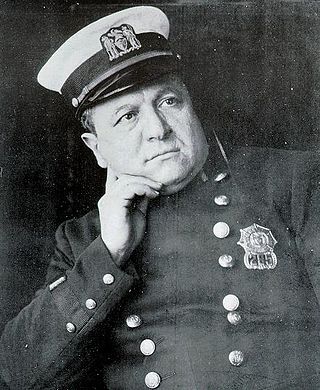
Joseph Petrosino was an Italian-born New York City Police Department (NYPD) officer who was a pioneer in the fight against organized crime. Crime fighting techniques that Petrosino pioneered are still practiced by law enforcement agencies.

The Manhattan Waterfront Greenway is a waterfront greenway for walking or cycling, 32 miles (51 km) long, around the island of Manhattan, in New York City. The largest portions are operated by the New York City Department of Parks and Recreation. It is separated from motor traffic, and many sections also separate pedestrians from cyclists. There are three principal parts — the East, Harlem and Hudson River Greenways.

Cortez Hill is a neighborhood located in the northeast part of downtown San Diego, California.

Lafayette Street is a major north–south street in New York City's Lower Manhattan. It originates at the intersection of Reade Street and Centre Street, one block north of Chambers Street. The one-way street then successively runs through Chinatown, Little Italy, NoLIta, and NoHo and finally, between East 9th and East 10th streets, merges with Fourth Avenue. A buffered bike lane runs outside the left traffic lane. North of Spring Street, Lafayette Street is northbound (uptown)-only; south of Spring Street, Lafayette is southbound (downtown)-only.
The Brooklyn–Queens Greenway is a bicycling and pedestrian path connecting parks and roads in the New York City boroughs of Brooklyn and Queens, connecting Coney Island in the south to Fort Totten in the north, on Long Island Sound. The route connects major sites in the two boroughs, such as the New York Aquarium, Brooklyn Museum, the Brooklyn Botanic Garden, the New York Hall of Science, and Citi Field.

Cycling in New York City is associated with mixed cycling conditions that include dense urban proximities, relatively flat terrain, congested roadways with stop-and-go traffic, and streets with heavy pedestrian activity. The city's large cycling population includes utility cyclists, such as delivery and messenger services; cycling clubs for recreational cyclists; and increasingly commuters. Cycling is increasingly popular in New York City; in 2018 there were approximately 510,000 daily bike trips, compared with 170,000 daily bike trips in 2005.

The East River Greenway is an approximately 9.44-mile-long (15.19 km) foreshoreway for walking or cycling on the east side of the island of Manhattan on the East River. It is part of the Manhattan Waterfront Greenway. The largest portions are operated by the New York City Department of Parks and Recreation. It is separated from motor traffic, and many sections also separate pedestrians from cyclists. The greenway is parallel to the Franklin D. Roosevelt East River Drive for a majority of its length.

Broome Street is an east–west street in Lower Manhattan. It runs nearly the full width of Manhattan island, from Hudson Street in the west to Lewis Street in the east, near the entrance to the Williamsburg Bridge. The street is interrupted in a number of places by parks, buildings, and Allen Street's median. The street was named after Staten Island-born John Broome, who was a Colonial merchant and politician and became a Lieutenant Governor of New York State.
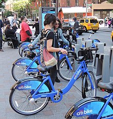
Citi Bike is a privately owned public bicycle sharing system serving the New York City boroughs of the Bronx, Brooklyn, Manhattan, and Queens, as well as Jersey City and Hoboken, New Jersey. Named after lead sponsor Citigroup, it was operated by Motivate, with former Metropolitan Transportation Authority CEO Jay Walder as chief executive until September 30, 2018, when the company was acquired by Lyft. The system's bikes and stations use technology from Lyft.

Elizabeth Street is a street in Manhattan, New York City, which runs north-south parallel to and west of the Bowery. The street is a popular shopping strip in Lower Manhattan's Nolita neighborhood.

Janet Freeman was an American community organizer and activist for tenant's rights in New York City's lower Manhattan. On June 20, 2013, the corner of Elizabeth Street and Kenmare Street was co-named "Janet Freeman Way" by the New York City Council in her memory and to commemorate her activism on behalf of the community. According to NYC Streets in its listing of street names and their honorees, "Janet Freeman was a community organizer and tenant advocate. She founded the Croman Tenants Association; the Coalition to Protect Public Housing and Section 8; and Co-op Watch, to prevent evictions through phony conversions. She started campaigns to organize tenants against aggressive landlords, phony demolitions, and harassment in and around Chinatown and Little Italy."
Lieutenant Joseph Petrosino Park is a New York City public park located in Bensonhurst, Brooklyn, New York City between 70th Street to the north, 71st Street to the south, 16th Avenue to the east, and New Utrecht Avenue to the west. It is on the east side of the 71st Street subway station. This part of Bensonhurst was within the Town of Nieuw Utrecht when it was founded during the Dutch colonial era in 1657. The town had its name Anglicized to New Utrecht during the English colonial era. The town lost its autonomous status and became part of the City of Brooklyn in 1894. Since 16th Avenue and New Utrecht Avenue do not run parallel to each other, the footprint of the park is trapezoidal in shape.
Anthony Catanzaro Square is located within a traffic triangle that is the result of three street grids that meet in the Bath Beach neighborhood of Brooklyn, New York. At this junction, West 16 Street meets its northern end at the same place where Avenue Y meets its western end, both of these roads meeting Bay 50th Street.