
New Amsterdam was a 17th-century Dutch settlement established at the southern tip of Manhattan Island that served as the seat of the colonial government in New Netherland. The initial trading factory gave rise to the settlement around Fort Amsterdam. The fort was situated on the strategic southern tip of the island of Manhattan and was meant to defend the fur trade operations of the Dutch West India Company in the North River. In 1624, it became a provincial extension of the Dutch Republic and was designated as the capital of the province in 1625.
Fort Amsterdam was a fort on the southern tip of Manhattan at the confluence of the Hudson and East rivers. It was the administrative headquarters for the Dutch and then English/British rule of the colony of New Netherland and subsequently the Province of New York from 1625 or 1626, until being torn down in 1790 after the American Revolution. It was the nucleus of the settlement in the area that became New Amsterdam and eventually New York City.

Lower Manhattan, also known as Downtown Manhattan or Downtown New York City, is the southernmost part of Manhattan, the central borough for business, culture, and government in New York City, which is the most populated city in the United States with over 8.8 million residents as of the 2020 census.

Little Germany, known in German as Kleindeutschland and Deutschländle and called Dutchtown by contemporary non-Germans, was a German immigrant neighborhood on the Lower East Side and East Village neighborhoods of Manhattan in New York City. The demography of the neighborhood began to change in the late 19th century, as non-German immigrants settled in the area. A steady decline of Germans among the population was accelerated in 1904, when the General Slocum disaster decimated the social core of the population with the loss of more than 1,000 lives.

Paulus Hook is a community on the Hudson River waterfront in Jersey City, New Jersey. It is located one mile across the river from Manhattan. The name Hook comes from the Dutch word "hoeck", which translates to "point of land." This "point of land" has been described as an elevated area, the location of which today is bounded by Montgomery, Hudson, Dudley and Van Vorst Streets. The neighborhood's main street is the north- and south-running Washington Street. The waterfront of Paulus Hook is located along the basin of the Morris Canal in a park with a segment of Liberty State Park. The Hudson-Bergen Light Rail has a Paulus Hook stop at Essex Street and the Liberty Water Taxi at Warren Street. The introduction of the light rail and development of office buildings on the Hudson Waterfront have brought more businesses to Morris Street including a number of restaurants with outdoor seating and small neighborhood shops.

Exchange Place is a district of Downtown Jersey City, New Jersey that is sometimes referred to as Wall Street West due to the concentration of financial companies that have offices there. The namesake is a square, about 200 feet long, at the foot of Montgomery Street at the Hudson River. This square was created by landfilling the shore at Paulus Hook, and has been a major transportation hub since the colonial era.

Whitehall Street is a street in the South Ferry/Financial District neighborhood of Lower Manhattan in New York City, near the southern tip of Manhattan Island. The street begins at Bowling Green to the north, where it is a continuation of the southern end of Broadway. Whitehall Street stretches four blocks to the southern end of FDR Drive, adjacent to the Staten Island Ferry's Whitehall Terminal, on landfill beyond the site of Peter Stuyvesant's 17th-century house.
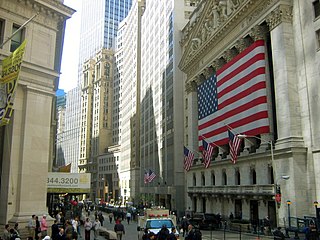
Broad Street is a north–south street in the Financial District of Lower Manhattan in New York City. Originally the Broad Canal in New Amsterdam, it stretches from today's South Street to Wall Street.

South Street is a street in Lower Manhattan, New York City, located immediately adjacent to the East River. It runs from Whitehall Street near the southern tip of Manhattan to Jackson Street near the Williamsburg Bridge. The Franklin D. Roosevelt East River Drive, in an elevated portion known as the South Street Viaduct, runs along the entire length of the street.

Clinton and Russell was a well-known architectural firm founded in 1894 in New York City, United States. The firm was responsible for several New York City buildings, including some in Lower Manhattan.
St. John's Park was a 19th-century park and square, and the neighborhood of townhouses around it, in what is now the Tribeca neighborhood of Lower Manhattan, New York City. The square was bounded by Varick Street, Laight Street, Hudson Street and Beach Street, now also known for that block as Ericsson Place. Although the name "St. John's Park" is still in use, it is no longer a park and is inaccessible to the public.

Greenwich Street is a north–south street in the New York City borough of Manhattan. It extends from the intersection of Ninth Avenue and Gansevoort Street in the Meatpacking District at its northernmost end to its southern end at Battery Park. Greenwich Street runs through the Meatpacking District, the West Village, Hudson Square, and Tribeca.

Maiden Lane is an east–west street in the Financial District of the New York City borough of Manhattan. Its eastern end is at South Street, near the South Street Seaport, and its western end is at Broadway near the World Trade Center site, where it becomes Cortlandt Street.

The American Bank Note Company Building is a five-story building at 70 Broad Street in the Financial District of Manhattan in New York City. The building was designed by architects Kirby, Petit & Green in the neo-classical style, and contains almost 20,000 square feet (1,900 m2) of space, with offices and residences on the upper floors. The exterior consists of a main facade on Broad Street with two columns, as well as side facades with pilasters on Beaver and Marketfield Streets.
The New York Gold Exchange was an exchange formed shortly after the beginning of the American Civil War for the purpose of creating an open market for transactions involving gold and the government-created paper currency, the greenback. Established in 1862, it closed in 1897.
Albany Street is a short street in the Financial District of Lower Manhattan in New York City. The street runs west-to-east from the Battery Park City Esplanade along the Hudson River to Greenwich Street, passing through South End Avenue and West Street on the way. The street has a walkway connection to the Rector Street Bridge which crosses West Street.

Cortlandt Street is a west-east street in the Financial District of Lower Manhattan, New York City. It runs one block from Broadway to Church Street, then continues an additional block as the non-vehicular Cortlandt Way from Church to Greenwich Street. At its eastern end, the street continues as Maiden Lane.

State Street is a short street in the Financial District of Manhattan, New York City. It runs west from Whitehall Street as a continuation of Water Street, then turns north at Battery Park to become its eastern border. Passing Pearl and Bridge Streets, it terminates at the northeast corner of the park, at Bowling Green, where the roadway continues north as Broadway and west as Battery Place.
Beaver Street is a street in the Financial District of Lower Manhattan in New York City. Beaver Street runs five blocks from Pearl Street in the east to Broadway in the west. Along its length, it crosses Hanover, William, Broad, and New Streets. The street is preserved as part of the New Amsterdam street grid, a New York City designated landmark.
Exchange Place is a street in the Financial District of Lower Manhattan, New York City. The street runs five blocks between Trinity Place in the west and Hanover Street in the east.
