Midtown Manhattan is the central portion of the New York City borough of Manhattan, serving as the city's primary central business district. Midtown is home to some of the city's most prominent buildings, including the Empire State Building, the Chrysler Building, the Hudson Yards Redevelopment Project, the headquarters of the United Nations, Grand Central Terminal, and Rockefeller Center, as well as several prominent tourist destinations, including Broadway, Times Square, and Koreatown. Penn Station in Midtown Manhattan is the busiest transportation hub in the Western Hemisphere.
Kips Bay, or Kip's Bay, is a neighborhood on the east side of the New York City borough of Manhattan. It is roughly bounded by 34th Street to the north, the East River to the east, 23rd Street to the south, and Third Avenue to the west.

Gerritsen Beach is a neighborhood in the New York City borough of Brooklyn, located between Sheepshead Bay to the west and Marine Park to the east. The area is served by Brooklyn Community Board 15. The population of the neighborhood is 4,797 as of the 2020 U.S. census.

Manhattan Beach is a residential neighborhood in the New York City borough of Brooklyn. It is bounded by the Atlantic Ocean to the south and east, by Sheepshead Bay on the north, and Brighton Beach to the west. Traditionally known as an Italian and Ashkenazi Jewish neighborhood, it is also home to a sizable community of Sephardi Jews and a large Russian Jewish immigrant presence.

Longwood is a mixed-use neighborhood in the southeast Bronx in New York City. Its boundaries, starting from the north and moving clockwise are East 167th Street to the north, the Bronx River and the Bruckner Expressway to east, East 149th Street to the south, and Saint Anns Avenue to the west. Southern Boulevard is the primary thoroughfare through Longwood.

Wakefield is a working-class and middle-class section of the northern borough of the Bronx in New York City. It is bounded by the city's border with Westchester County to the north, East 222nd Street to the south, and the Bronx River Parkway to the west.

Fordham Manor is a neighborhood located in the western Bronx, New York City. Fordham is roughly bordered by East 196th Street to the north, the Harlem River to the west, Fordham Road to the south, and Southern Boulevard to the east. The neighborhood's primary thoroughfares are Fordham Road and Grand Concourse.
Tremont is a residential neighborhood in the West Bronx, New York City. Its boundaries are East 181st Street to the north, Third Avenue to the east, the Cross-Bronx Expressway to the south, and the Grand Concourse to the west. East Tremont Avenue is the primary thoroughfare through Tremont.
Graniteville is a neighborhood in Staten Island, one of the five boroughs of New York City.

Country Club is a residential neighborhood located in the East Bronx in New York City. The neighborhood's boundaries are Middletown Road and Watt Avenue to the north, Eastchester Bay to the east, Layton Avenue and the Throggs Neck neighborhood to the south, and the New England Thruway and Pelham Bay neighborhood to the west. Pelham Bay Park, the largest public park in New York City, is located just north of Country Club.
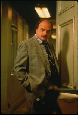
Andrew Sipowicz Sr. is a fictional character on the popular ABC television series NYPD Blue. Andy began as the secondary focus of a more ensemble-like show, but by the middle of Season 6 he is the clear protagonist of the show and receives the main storyline in every episode. Dennis Franz portrayed the character for its entire run.
Kingsbridge Heights is a residential neighborhood geographically located in the northwest Bronx, New York City. Its boundaries are Van Cortlandt Park to the north, Jerome Avenue to the east, Kingsbridge Road to the south, and the Major Deegan Expressway to the west. Sedgwick Avenue is the primary thoroughfare through Kingsbridge Heights.
The West Village is a neighborhood in the western section of the larger Greenwich Village neighborhood of Lower Manhattan, New York City. The West Village is bounded by the Hudson River to the west and 14th Street to the north. The eastern boundary is variously cited as Greenwich Avenue, Seventh Avenue, or Sixth Avenue, while the southern boundary is either Houston Street or Christopher Street.

South Ozone Park is a neighborhood in the southwestern section of the New York City borough of Queens. It is just north of John F. Kennedy International Airport, between Aqueduct Racetrack to the west and the Van Wyck Expressway to the east. Adjacent neighborhoods include Ozone Park to the west; Richmond Hill to the north; Jamaica, South Jamaica, and Springfield Gardens to the east; and Howard Beach and Old Howard Beach to the southwest.

Homecrest is a neighborhood situated in the New York City borough of Brooklyn, sometimes considered as part of Sheepshead Bay. It is bordered by Kings Highway to the north, Avenue X to the south, Coney Island Avenue to the west, and Ocean Avenue to the east.

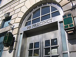
The New York City Police Department (NYPD) is structured into numerous bureaus and units. As a whole, the NYPD is headed by the Police Commissioner, a civilian administrator appointed by the Mayor, with the senior sworn uniformed officer of the service titled "Chief of Department". The Police Commissioner appoints the First Deputy Commissioner as the department's second-in-command and the Chief of Department as the department's highest ranking uniformed officer. The commissioner also appoints a number of deputy and assistant commissioners who do not have operational command and are solely for support and administrative function. The department is divided into twenty bureaus, six of which are enforcement bureaus. Each enforcement bureau is further subdivided into sections, divisions, and units, and into patrol boroughs, precincts, and detective squads. Each bureau is commanded by a bureau chief. There are also a number of specialized units that are not part of any of the bureaus and report to the Chief of the Department.

Charles McDonnell was an American law enforcement officer and police captain in the New York City Police Department. Popularly known as "Lightning Charlie", he was responsible for a number of high-profile arrests during the 1870s/80s, including those of procuress Jane the Grabber and gambler Samuel S. Brewster.
Thomas Woolsey Thorne was an American law enforcement officer and police inspector for the New York City Police Department. He is credited for breaking up the Daybreak Boys, a gang of river pirates active along the New York waterfront during the 1850s, by closing their dive bar headquarters in Slaughter House Point. He is also one of the commanding officers during the Draft Riots of 1863, in charge of the City Hall Police, and helped defend the New York Tribune.

The Detective Bureau is one of 14 bureaus within the New York City Police Department and is headed by the three-star Chief of Detectives. The Detective Squad was formed in 1857 with the Detective Bureau later formed in 1882.

Midtown South is a macro-neighborhood of the borough of Manhattan in New York City, generally characterized as constituting the southern portion of Midtown Manhattan. Midtown Manhattan hosts over 700,000 daily employees as a busy hub for workers, residents, and tourists. The Empire State Building, the Flatiron Building, Pennsylvania Station, Madison Square Garden, the Macy's Herald Square flagship store, Koreatown, and NYU Langone Medical Center are all located in Midtown South.