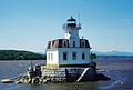
Rondout Light

Last updated
Rondout Light
Rondout 2 Lighthouse, Kingston (Ulster County, New York).jpg
Rondout Light
LocationHudson River at Rondout Creek, Kingston, New York
Coordinates 41°55′15″N73°57′45″W / 41.92083°N 73.96250°W / 41.92083; -73.96250
Tower
Constructed1838
FoundationConcrete pier with wood piles
ConstructionBrick
Automated1954
Height48 feet (15 m)
ShapeSquare tower with attached house
MarkingsYellow brick with black lantern
HeritageNational Register of Historic Places listed place  OOjs UI icon edit-ltr-progressive.svg
Fog signal Horn (removed)
Light
First lit1915 (current tower)
Focal height54 feet (16 m)
LensSixth order Fresnel lens (original), 9.8 inches (250 mm) (current)
Range9 nautical miles (17 km; 10 mi)
Characteristic Flashing White, 6 secs
Kingston/Rondout 2 Lighthouse
Arealess than one acre
Built1915
MPS Hudson River Lighthouses TR
NRHP reference No. 79001640 [1]
Added to NRHPMay 29, 1979

Rondout Light is a lighthouse on the west side of the Hudson River at Kingston, New York. [2] [3] [4]

Contents

Nomenclature

History

The first lighthouse at the entrance to the Rondout Creek was a wooden one built in 1837. It was replaced by a second lighthouse, made of sturdier bluestone, in 1867. The bluestone lighthouse was abandoned after 1915 and torn down in the 1950s. Only its circular stone foundation remains today. [5]

The current lighthouse was built in 1915, replacing the earlier 1867 lighthouse. In 1954 the light was automated and the building closed. [5] The National Historic Lighthouse Preservation Act provides for the Coast Guard to declare some lighthouses surplus, and for their ownership to be transferred to historical, non-profit or local government entities following an application process and review. Nine lighthouses were identified in the fall of 2001 as part of a pilot program to transfer such lighthouses. Rondout Light was one of those nine. [6] Rondout Light was transferred from the Coast Guard to the City of Kingston in 2002. [7] It is currently managed by the non-profit Hudson River Maritime Museum.

It was listed on the National Register of Historic Places in 1979. [1] [8]

Related Research Articles

<span class="mw-page-title-main">Stepping Stones Light</span> Lighthouse

Stepping Stones Light is a Victorian-style lighthouse in Long Island Sound, in Nassau County, New York. The lighthouse is square-shaped and made of red brick, standing one-and-a-half stories high. The Hudson-Athens Lighthouse is a virtual twin of this structure. The light is in current use, under the management of the United States Coast Guard. It is not open to the public.

<span class="mw-page-title-main">Rondout Creek</span> River in New York, United States

Rondout Creek is a 63.3-mile-long (101.9 km) tributary of the Hudson River in Ulster and Sullivan counties, New York, United States. It rises on Rocky Mountain in the eastern Catskills, flows south into Rondout Reservoir, part of New York City's water supply network, then into the valley between the Catskills and the Shawangunk Ridge, where it goes over High Falls and finally out to the Hudson at Kingston, receiving along the way the Wallkill River.

<span class="mw-page-title-main">Rondout, New York</span>

Rondout, is situated in Ulster County, New York on the Hudson River at the mouth of Rondout Creek. Originally a maritime village, the arrival of the Delaware and Hudson Canal helped create a city that dwarfed nearby Kingston. Rondout would become the third largest port on the Hudson River. Rondout merged with Kingston in 1872. It now includes the Rondout-West Strand Historic District.

<span class="mw-page-title-main">Esopus Meadows Light</span> Lighthouse

Esopus Meadows Lighthouse, nicknamed "Maid of the Meadows" and often simply referred to as the Esopus Light or Middle Hudson River Light is an active lighthouse on the Hudson River near Esopus, New York. The lighthouse stands on the west side of the channel, in the river, its granite foundation built atop piles that have been driven into the riverbed, and is accessible only by boat.

<span class="mw-page-title-main">Stony Point Light</span> Lighthouse

The Stony Point Light is the oldest lighthouse on the Hudson River. It is located at the Stony Point Battlefield in Stony Point, New York.

<span class="mw-page-title-main">DeTour Reef Light</span> Lighthouse in Michigan, United States

The DeTour Reef Light is a non-profit-operated lighthouse marking the southern entrance of the DeTour Passage between the eastern end of Michigan's Upper Peninsula and Drummond Island. The light is an automated active aid to navigation. It marks the northern end of Lake Huron. The passage is used by almost all of the Great Lakes commercial freighter traffic moving to and from Lake Superior, with approximately 5,000 vessel movements annually. It is said to be "the gateway to Lake Superior." In addition, many recreational boaters use the passage. The Light is located in Lake Huron, three miles (5 km) south of the nearest town, DeTour Village, Michigan.

<span class="mw-page-title-main">Robbins Reef Light</span> 1883 sparkplug lighthouse, Bayonne, NJ

The Robbins Reef Light Station is a sparkplug lighthouse located off Constable Hook in Bayonne, Hudson County, New Jersey, United States, along the west side of Main Channel, Upper New York Bay. The tower and integral keepers quarters were built in 1883. It replaced an octagonal granite tower built in 1839. The U.S. Coast Guard owned and operated the light station until the 2000s.

<span class="mw-page-title-main">Saginaw River Rear Range Light</span> Lighthouse in Michigan, United States

The first Saginaw River lighthouse was constructed from 1839 to 1841, in a period when large quantities of lumber were being harvested and shipped from the heart of Michigan via river and the Great Lakes to the East Coast of the United States via the Erie Canal and Hudson River. This connection to major eastern markets was critical to the development of central Michigan.

<span class="mw-page-title-main">Hudson–Athens Lighthouse</span> Lighthouse in New York, United States

The Hudson–Athens Lighthouse, sometimes called the Hudson City light, is a lighthouse located in the Hudson River in the state of New York in the United States. The light is located between Hudson and Athens, closer to the Hudson side. Constructed in 1874, it marks a sandy ridge known as Middle Ground Flats and also acts as a general aid to navigation of the river. The station is built on a granite caisson with a unique shape designed to protect it from ice floes and river debris. The dwelling is constructed in the Second Empire architectural style, with a mansard roof. It is considered to be virtually a twin of the Stepping Stones Light in Long Island Sound, which was constructed just a few years later.

<span class="mw-page-title-main">Oswego Harbor West Pierhead Light</span> Lighthouse

Oswego Harbor West Pierhead Lighthouse is an active aid to navigation located off the coast of Oswego, New York. It was built in 1934 to replace an earlier light constructed in 1880. It stands at the end of a 2,000-foot-long (610 m) breakwater at mouth of Oswego River, extending one-half mile (0.80 km) out onto Lake Ontario. It is accessible by boat or from land over the abutting breakwater. It is open to the public for tours during the summer. It is owned by the City of Oswego and operated by the United States Coast Guard. It is listed on the National Register of Historic Places.

<span class="mw-page-title-main">Chicago Harbor Light</span> Lighthouse

The Chicago Harbor Lighthouse is an automated active lighthouse, and stands at the south end of the northern breakwater protecting the Chicago Harbor, to the east of Navy Pier and the mouth of the Chicago River.

The National Historic Lighthouse Preservation Act of 2000 is American legislation creating a process for the transfer of federally owned lighthouses into private hands. It was created as an extension of the National Historic Preservation Act of 1966.

<span class="mw-page-title-main">Staten Island Light</span> Lighthouse

The Staten Island Range Light, also known as the Ambrose Channel Range Light, is the rear range light companion to the West Bank Lighthouse. Built in 1912, the 90-foot tower sits more than five miles northwest of the West Bank Lighthouse, on Staten Island’s Richmond Hill, 141 feet above sea level. It shows a fixed white light that can be seen for 18 miles, by all vessels bound to New York and New Jersey Ports coming in from the Atlantic Ocean.

<span class="mw-page-title-main">Rondout–West Strand Historic District</span> Historic district in New York, United States

The Rondout–West Strand Historic District is located on the shore of Rondout Creek along the southern boundary of the city of Kingston, New York, United States. Formerly Rondout, New York, it is bounded by the creek, Broadway, Hone, Ravine and McEntee streets, an area of 570 acres (2.3 km²) containing 259 buildings, most dating to the 19th century. US 9W and the John T. Loughran Bridge are immediately to the east; the Kingston-Port Ewen Suspension Bridge crosses the creek to the west. The neighborhood is often referred to locally by either of the two names.

<span class="mw-page-title-main">Hudson River Maritime Museum</span>

The Hudson River Maritime Museum is a maritime museum dedicated to the Hudson River.

<span class="mw-page-title-main">Saugerties Light</span> Lighthouse

Saugerties Light, known also as the Saugerties Lighthouse, is a lighthouse on the Hudson River north of Saugerties, New York.

<span class="mw-page-title-main">East Charity Shoal Light</span> Lighthouse

East Charity Shoal Light is an offshore lighthouse located near the Saint Lawrence River's entrance in northeastern Lake Ontario, due south of the city of Kingston, Ontario and approximately five miles (8 km) southwest of Wolfe Island. It is on the southeast rim of a 3,300-foot-diameter (1,000 m) submerged circular depression known as Charity Shoal Crater that may be the remnants of a meteorite impact.

<span class="mw-page-title-main">Old Orchard Shoal Light</span> Lighthouse

Old Orchard Shoal Light was a sparkplug lighthouse in lower New York Bay marking a large shoal area. It was destroyed by Hurricane Sandy on October 29, 2012.

<span class="mw-page-title-main">Romer Shoal Light</span> Lighthouse

Romer Shoal Light is a sparkplug lighthouse in Lower New York Bay, on the north edge of the Swash Channel, about 34 nautical mile south of Ambrose Channel and 2+12 nautical miles north of Sandy Hook, New Jersey, in the entrance to New York Harbor. It is in New Jersey, very close to the border with New York. Named as Romer Shoal Light Station, it was added to the National Register of Historic Places on January 24, 2007, for its significance in architecture, engineering, transportation, and maritime history.

<span class="mw-page-title-main">Chestnut Street Historic District (Kingston, New York)</span> Historic district in New York, United States

Chestnut Street Historic District is a national historic district located at Kingston in Ulster County, New York. The district includes 44 contributing buildings and six contributing structures. It comprises a collection of substantial 19th and early 20th century residences on dramatic hillside sites. It also includes the Immanuel Lutheran Church and Bruck Funeral Home.

References

  1. 1 2 "National Register Information System". National Register of Historic Places . National Park Service. March 13, 2009.
  2. 1 2 3 Light List, Volume I, Atlantic Coast, St. Croix River, Maine to Shrewsbury River, New Jersey (PDF). Light List. United States Coast Guard. 2009. p. 318.
  3. 1 2 "Historic Light Station Information and Photography: New York". United States Coast Guard Historian's Office. Archived from the original on 2017-05-01.
  4. Rowlett, Russ (2009-12-24). "Lighthouses of the United States: Downstate New York". The Lighthouse Directory. University of North Carolina at Chapel Hill.
  5. 1 2 ""Rondout Lighthouse", Hudson River Maritime Museum". Archived from the original on 2014-11-11. Retrieved 2014-11-11.
  6. NHLPA 2001 Transfer Pilot Program
  7. Hudson Lights
  8. Elise Marie Barry (February 1979). "National Register of Historic Places Registration: Kingston/Rondout 2 Lighthouse". New York State Office of Parks, Recreation and Historic Preservation. Archived from the original on 2012-10-11. Retrieved 2010-03-20.See also: "Accompanying two photos". Archived from the original on 2012-10-11. Retrieved 2010-04-03.