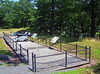
Fort Montgomery was a fortification built on the west bank of the Hudson River in Highlands, New York by the Continental Army during the American Revolution. Erected in 1776, Fort Montgomery was one of the first major investments by the Americans in strategic construction projects.

The Hudson River is a 315-mile (507 km) river that flows from north to south primarily through eastern New York, United States. It originates in the Adirondack Mountains of upstate New York at Henderson Lake in the town of Newcomb, and flows southward through the Hudson Valley to the New York Harbor between New York City and Jersey City, eventually draining into the Atlantic Ocean at Upper New York Bay. The river serves as a physical boundary between the states of New Jersey and New York at its southern end. Farther north, it marks local boundaries between several New York counties. The lower half of the river is a tidal estuary, deeper than the body of water into which it flows, occupying the Hudson Fjord, an inlet that formed during the most recent period of North American glaciation, estimated at 26,000 to 13,300 years ago. Even as far north as the city of Troy, the flow of the river changes direction with the tides.

Saratoga County is a county in the U.S. state of New York, and is the fastest-growing county in Upstate New York. As of the 2020 U.S. census, the county's population was enumerated at 235,509, its highest decennial count ever and a 7.2% increase from the 219,607 recorded at the 2010 census, representing one of the fastest growth rates in the northeastern United States; and despite the worldwide toll of the COVID-19 pandemic in the early 2020s, Saratoga County has continued its rapid growth. The county seat is Ballston Spa. The county is part of the Capital District region of the state.

Malta is a town in Saratoga County, New York, United States. The town is in the central part of the county and is south of Saratoga Springs. The population was 17,130 as of the 2020 census.

Stillwater is a town in Saratoga County, New York, United States, with a population of 9,022 at the 2020 census. The town contains a village called Stillwater. The town is at the eastern border of the county, southeast of Saratoga Springs and borders both Rensselaer and Washington counties. Saratoga National Historical Park is located within the town's limits. There is a hamlet in Minerva, Essex County, New York, with the same name which has nothing to do with this town.

Waterford is a town in Saratoga County, New York, United States. The population was 8,208 at the 2020 census. The name of the town is derived from its principal village, also called Waterford. The town is located in the southeast corner of Saratoga County and north-northwest of Troy at the junction of the Erie Canal and the Hudson River.
Marist College is a private university in Poughkeepsie, New York. Founded in 1905, Marist was formed by the Marist Brothers, a Catholic religious institute, to prepare brothers for their vocations as educators. By 1969, the college had become private with a predominantly lay board of trustees and in 2003, the Catholic Church recognized Marist as a secular institution.

The Great Sacandaga Lake is a large lake situated in the Adirondack Park in northern New York in the United States. The lake has a surface area of about 41.7 square miles (108 km2) at capacity, and the length is about 29 miles (47 km). The word Sacandaga means "Land of the Waving Grass" in the native Mohawk language. The lake is located in the northern parts of Fulton County and Saratoga County near the southern border of the Adirondack Park. A small portion also extends northward into southern Hamilton County. The broader, south end of the lake is northeast of the City of Johnstown and the City of Gloversville. Great Sacandaga Lake is a reservoir created by damming the Sacandaga River. The primary purpose for the creation of the reservoir was to control flooding on the Hudson River and the Sacandaga River, floods which had a historically significant impact on the surrounding communities.

Saratoga National Historical Park is a United States National Historical Park located in the Town of Stillwater in eastern New York, 30 miles north of Albany. The park preserves the site of the Battles of Saratoga.

The John H. Chafee Blackstone River Valley National Heritage Corridor is a National Heritage Corridor dedicated to the history of the early American Industrial Revolution, including mill towns stretching across 25 cities and towns near the river's course in Worcester County, Massachusetts, and Providence County, Rhode Island. It makes up a historical area in the Blackstone Valley and is named for the late US Senator from Rhode Island John Chafee. In 2014, the Blackstone River Valley National Historical Park was created out of a smaller portion of the National Heritage Corridor. The two units now exist as cooperative entities. The organization is headquartered at the building in Whitinsville, MA, which is located at 670 Linwood Ave, Whitinsville, MA 01588.
The Crossroads of the American Revolution National Heritage Area (XRDS) is a federally designated National Heritage Area encompassing portions of 14 counties in New Jersey that were the scene of significant actions in the American Revolutionary War in late 1776 through 1778. The designated area covers the Delaware and Hudson valleys in New Jersey and the central portion of the state between the valleys where the Continental Army fought forces under British command. The National Heritage Area includes Morristown National Historical Park and sites associated with the Battle of Monmouth as well as Princeton, New Jersey, the meeting place of the Continental Congress when peace was declared in 1783.
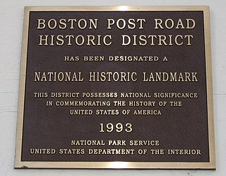
The Boston Post Road Historic District is a 286-acre (116 ha) National Historic Landmark District in Rye, New York, and is composed of five distinct and adjacent properties. Within this landmarked area are three architecturally significant, pre-Civil War mansions and their grounds; a 10,000-year-old Indigenous peoples site and viewshed; a private cemetery, and a nature preserve. It is one of only 11 National Historic Landmark Districts in New York State and the only National Historic Landmark District in Westchester County. It touches on the south side of the nation's oldest road, the Boston Post Road, which extends through Rye. A sandstone Westchester Turnpike marker "24", inspired by Benjamin Franklin's original mile marker system, is set into a wall that denotes the perimeter of three of the contributing properties. The district reaches to Milton Harbor of Long Island Sound. Two of the properties included in the National Park Service designation are anchored by Greek Revival buildings; the third property is dominated by a Gothic Revival structure that was designed by Alexander Jackson Davis.
Stark's Knob is a basaltic pillow lava formation near Schuylerville, New York, United States. It formed about 460 to 440 million years ago in relatively shallow sea water. It is often mistakenly referred to as a volcano, probably because early investigators described it as a volcano or volcanic plug.
Historic preservation in New York is activity undertaken to conserve forests, buildings, ships, sacred burial grounds, water purity and other objects of cultural importance in New York in ways that allow them to communicate meaningfully about past practices, events, and people.

The area of New York's Capital District, also known as the Albany metropolitan area, has seen prominent historical events, artistic creations, and unique contributions to the culture of the United States since the 17th century. The largest city in the area, Albany, consistently ranks high on lists of top cities/metro areas for culture, such as being 23rd in the book Cities Ranked & Rated. The Albany-Schenectady-Troy metro area ranked 12th among large metro areas, and Glens Falls ranked 12th among the small metro areas, in Sperling's Best Places, and Expansion Management gave the Albany-Schenectady-Troy area five Stars, its highest ranking, for quality of life features.
The Hudson River Valley Institute is a center for regional studies of the Hudson Valley of New York State. It is an academic extension of Marist College in Poughkeepsie, New York.
The Saratoga and North Creek Railway was a heritage railway that began operation in July 2011. Passenger operations ceased on April 7, 2018, and the final revenue freight train to remove stored tank cars operated in May 2018. The railroad ran in the upper Hudson River region of the Adirondack Mountains, in the U.S. state of New York.
The Champlain Valley National Heritage Area is a federally designated National Heritage Area encompassing eleven counties in New York and Vermont surrounding Lake Champlain. The heritage area designation recognizes the area's historical and scenic significance. The region was a strategic corridor between the Hudson Valley of the United States and the Richelieu Valley of Quebec during the American Revolution in the late 18th century, and saw considerable military action during the War of 1812. During the American Civil War the valley was a part of the Underground Railroad network.

Schuylkill River National and State Heritage Area is a federally designated National Heritage Area in the valley of the Schuylkill River in southeastern Pennsylvania. The heritage area extends from Pottsville to Philadelphia through Schuylkill, Berks, Chester, Montgomery and Philadelphia counties. The national heritage area interprets and promotes the river's history during the American Revolution and the Industrial Revolution, as well as its natural environment and its recreational use.

The Maritje Kill is a tributary of the Hudson River in Hyde Park, New York. Its source is three miles northeast of the village of Hyde Park, and it enters the Hudson at the Hyde Park campus of the Culinary Institute of America (CIA). The river's name uses an old Dutch version of the given name Marietje, meaning "little Mary". It is one of two major waterways in Hyde Park, and flows north to south through the town.
