Related Research Articles

Nevada is a state in the Western region of the United States. It is bordered by Oregon to the northwest, Idaho to the northeast, California to the west, Arizona to the southeast, and Utah to the east. Nevada is the 7th-most extensive, the 32nd-most populous, and the 9th-least densely populated of the U.S. states. Nearly three-quarters of Nevada's people live in Clark County, which contains the Las Vegas–Paradise metropolitan area, including three of the state's four largest incorporated cities. Nevada's capital is Carson City while the largest city is Las Vegas.

Utah is a state in the Mountain West subregion of the Western United States. Utah is a landlocked U.S. state bordered to its east by Colorado, to its northeast by Wyoming, to its north by Idaho, to its south by Arizona, and to its west by Nevada. Utah also touches a corner of New Mexico in the southeast. Of the fifty U.S. states, Utah is the 13th-largest by area; with a population over three million, it is the 30th-most-populous and 11th-least-densely populated. Urban development is mostly concentrated in two areas: the Wasatch Front in the north-central part of the state, which is home to roughly two-thirds of the population and includes the capital city, Salt Lake City; and Washington County in the southwest, with more than 180,000 residents. Most of the western half of Utah lies in the Great Basin.

Juab County is a county in western Utah, United States. As of the 2010 United States Census, the population was 10,246. Its county seat and largest city is Nephi.

Millard County is a county in the U.S. state of Utah. As of the 2010 United States Census, the population was 12,503. Its county seat is Fillmore, and the largest city is Delta.
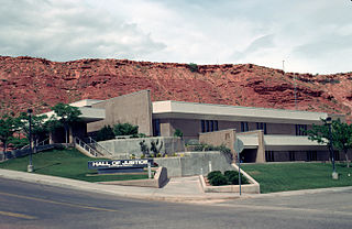
Washington County is a county in the southwestern corner of Utah, United States. As of the 2020 United States Census, the population was 180,279, making it the fifth-most populous county in Utah. Its county seat and largest city is St. George. The county was created in 1852 and organized in 1856. It was named after the first President of the United States, George Washington. A portion of the Paiute Indian Reservation is in western Washington County. Washington County comprises the St. George, UT Metropolitan Statistical Area.
Interstate 15 (I-15) is a major Interstate Highway in the western United States, running through Southern California and the Intermountain West. I-15 begins near the Mexican border in San Diego County and stretches north to Alberta, Canada, passing through the states of California, Nevada, Arizona, Utah, Idaho, and Montana. The Interstate serves the cities of San Diego, San Bernardino, Las Vegas, St. George, Provo, Salt Lake City, Ogden, Pocatello, Idaho Falls, Butte, Helena, and Great Falls. It also passes close to the urban areas of Los Angeles, Orange, and Riverside counties, California. The stretches of I-15 in Idaho, Utah, and Arizona have been designated as the "Veterans Memorial Highway". The southern end is at a junction with I-8 and State Route 15 (SR 15) in San Diego, and the northern end is at a connection with Alberta Highway 4 at the Sweetgrass–Coutts Border Crossing.
Scouting in Utah has a long history, from the 1910s to the present day, serving thousands of youth in programs that suit the environment in which they live.

Great Basin National Park is an American national park located in White Pine County in east-central Nevada, near the Utah border, established in 1986. The park is most commonly entered by way of Nevada State Route 488, which is connected to U.S. Routes 6 and 50 by Nevada State Route 487 via the small town of Baker, the closest settlement.

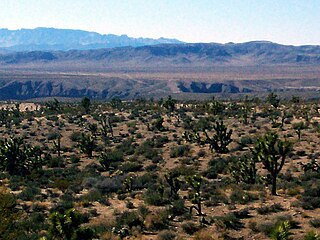
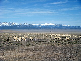
The Great Basin is the largest area of contiguous endorheic watersheds – those with no outlets – in North America. It spans nearly all of Nevada, much of Utah, and portions of California, Idaho, Oregon, Wyoming, and Baja California, Mexico. It is noted for both its arid climate and the basin and range topography that varies from the North American low point at Badwater Basin in Death Valley to the highest point of the contiguous United States, less than 100 miles (160 km) away at the summit of Mount Whitney. The region spans several physiographic divisions, biomes, ecoregions, and deserts.

The State of Deseret was a provisional state of the United States, proposed in 1849 by settlers from The Church of Jesus Christ of Latter-day Saints in Salt Lake City. The provisional state existed for slightly over two years and was never recognized by the United States government. The name derives from the word for "honeybee" in the Book of Mormon.

The Territory of Utah was an organized incorporated territory of the United States that existed from September 9, 1850, until January 4, 1896, when the final extent of the territory was admitted to the Union as the State of Utah, the 45th state. At its creation, the Territory of Utah included all of the present-day State of Utah, most of the present-day state of Nevada, much of present-day western Colorado, and the extreme southwest corner of present-day Wyoming.

The Indigenous peoples of the Great Basin are Native Americans of the northern Great Basin, Snake River Plain, and upper Colorado River basin. The "Great Basin" is a cultural classification of indigenous peoples of the Americas and a cultural region located between the Rocky Mountains and the Sierra Nevada, in what is now Nevada, and parts of Oregon, California, Idaho, Wyoming, and Utah. The Great Basin region at the time of European contact was ~400,000 sq mi (1,000,000 km2). There is very little precipitation in the Great Basin area which affects the lifestyles and cultures of the inhabitants.

Baker is a census-designated place in southeastern White Pine County, Nevada, United States. It is located 5 miles (8.0 km) east of the main entrance of Great Basin National Park at the junction of State Routes 487 and 488. The town is named after an early settler, George W. Baker. Its population at the 2010 census was 68.
U.S. Route 50 (US 50) is a transcontinental highway in the United States, stretching from West Sacramento, California, in the west to Ocean City, Maryland, on the east coast. The Nevada portion crosses the center of the state and was named "The Loneliest Road in America" by Life magazine in July 1986. The name was intended as a pejorative, but Nevada officials seized it as a marketing slogan. The name originates from large desolate areas traversed by the route, with few or no signs of civilization. The highway crosses several large desert valleys separated by numerous mountain ranges towering over the valley floors, in what is known as the Basin and Range province of the Great Basin.
U.S. Route 50 (US-50) in Utah crosses the center of the state. The highway serves no major population centers in Utah, with the largest city along its path being Delta. Most of the route passes through desolate, remote areas. Through the eastern half of the state the route is concurrent with Interstate 70 (I-70). US-50 both enters and exits Utah concurrent with US-6, however the two routes are separate through the center of the state.
The Beaver Dam Wash is a seasonal stream near the southwestern Utah-Nevada border in the United States. At its southern end in northern Arizona, near the point where it empties into the Virgin River, the stream flows throughout the year. Part of the wash is in the Beaver Dam Wash National Conservation Area, managed by the Bureau of Land Management. The wash was so named on account of beaver dams which once were built on its course.
U.S. Route 6 is a transcontinental highway in the United States, stretching from Bishop, California, in the west to Provincetown, Massachusetts, on the east coast. The Nevada portion crosses the center of the state, serving the cities of Tonopah and Ely, en route to Utah and points further east. Like US 50, to the north, large desolate areas are traversed by the route, with few or no signs of civilization, and the highway crosses several large desert valleys separated by numerous mountain ranges towering over the valley floors, in what is known as the Basin and Range Province of the Great Basin.
Snake Valley is a north-south trending valley that straddles the Nevada–Utah border in the central Great Basin. It is bound by the Snake Range and the Deep Creek Mountains to the west and the Confusion Range to the east. The valley is the gateway to Great Basin National Park and Lehman Caves, which is located in the western part of the valley and on the southern Snake Range.

The Carson Desert is a desert in the Lahontan Basin and the desert valley of Churchill County, Nevada (U.S.), which receives an average 5 inches (130 mm) annual precipitation. The desert is the low valley area between the adjacent mountain ranges, while the larger watershed includes the interior slopes of the demarcating ranges. The desert was inundated by Lake Lahontan during the Pleistocene, and the watershed became part of Nevada's Conservation Security Program in 2005.

The Mountain States form one of the nine geographic divisions of the United States that are officially recognized by the United States Census Bureau. It is a subregion of the Western United States.
References
- 1 2 "About Great Basin National Heritage Area Partnership". Great Basin National Heritage Area. Archived from the original on 5 March 2012. Retrieved 17 April 2012.
- ↑ "Features of Great Basin National Heritage Area". Great Basin National Heritage Area. Archived from the original on 16 May 2012. Retrieved 17 April 2012.