
Fairborn is a city in Greene County, Ohio, United States, near Dayton and Wright-Patterson Air Force Base. The population was 32,770 at the 2010 census. It is the only city in the world with the name of Fairborn, a portmanteau word created from the names Fairfield and Osborn, the two villages that merged in 1950. After the Great Dayton Flood of 1913, the region and state created a conservation district here and began construction of Huffman Dam on the Mad River in the 1920s for flood control. Residents of Osborn were relocated with their houses to an area alongside Fairfield.

Wright-Patterson Air Force Base (WPAFB) is a United States Air Force base and census-designated place just east of Dayton, Ohio, in Greene and Montgomery counties. It includes both Wright and Patterson Fields, which were originally Wilbur Wright Field and Fairfield Aviation General Supply Depot. Patterson Field is approximately 16 kilometres (10 mi) northeast of Dayton; Wright Field is approximately 8.0 kilometres (5 mi) northeast of Dayton.

The bicycle business of the Wright brothers, the Wright Cycle Company successively occupied six different locations in Dayton, Ohio. Orville and Wilbur Wright began their bicycle repair, rental and sales business in 1892, while continuing to operate a print shop. In 1896 they began manufacturing and selling bicycles of their own design, the Van Cleve and St. Claire, named after their ancestors. They invented the self-oiling hub and devised the innovation of machining the crankarm and pedal on the left side with left-hand threads to prevent the pedal from coming unscrewed while cycling. The brick building at 22 South Williams St., where the Wrights worked from 1895 to 1897, is the only extant building on its original foundation and in its original location that housed a Wright bicycle shop. They ran their printing shop on the second-floor. The 22 South Williams Street building is part of Dayton Aviation Heritage National Historical Park and the National Aviation Heritage Area.
The Wright Company was the commercial aviation business venture of the Wright Brothers, established by them on November 22, 1909, in conjunction with several prominent industrialists from New York and Detroit with the intention of capitalizing on their invention of the practical airplane. The company maintained its headquarters office in New York City and built its factory in Dayton, Ohio.

Fort Ancient is a Native American earthworks complex located in Washington Township, Warren County, Ohio, along the eastern shore of the Little Miami River about seven miles (11 km) southeast of Lebanon on State Route 350. The site is the largest prehistoric hilltop enclosure in the United States with three and one-half miles (18,000 ft) of walls in a 100-acre (0.40 km2) complex. Built by the Hopewell culture, who lived in the area from the 200 BC to AD 400, the site is situated on a wooded bluff 270 feet (82 m) above the Little Miami. It is the namesake of a culture known as Fort Ancient who lived near the complex long after it was constructed.

Wright Brothers National Memorial, located in Kill Devil Hills, North Carolina, commemorates the first successful, sustained, powered flights in a heavier-than-air machine. From 1900 to 1903, Wilbur and Orville Wright came here from Dayton, Ohio, based on information from the U.S. Weather Bureau about the area's steady winds. They also valued the privacy provided by this location, which in the early twentieth century was remote from major population centers.

The Armstrong Air and Space Museum is a museum in Wapakoneta, Ohio, United States, the hometown of Neil Armstrong, first man to set foot on the Moon. The museum chronicles Ohio's contributions to the history of space flight. Among the items on display are an F5D Skylancer, the Gemini 8 spacecraft in which Armstrong flew, Apollo 11 artifacts and a Moon rock. In the museum's Astro-theater, multimedia presentations of the sights and sounds of space unfold against a starry background.

Huffman Prairie, also known as Huffman Prairie Flying Field or Huffman Field is part of Ohio's Dayton Aviation Heritage National Historical Park. The 84-acre (34-hectare) patch of rough pasture, near Fairborn, northeast of Dayton, is the place where the Wright brothers undertook the difficult and sometimes dangerous task of creating a dependable, fully controllable airplane and training themselves to be pilots. Many early aircraft records were set by the Wrights at the Huffman Prairie.

Carillon Historical Park is a 65-acre park and museum in Dayton, Ohio, which contains historic buildings and exhibits concerning the history of technology and the history of Dayton and its residents from 1796 to the present. The historical elements of the park were the brainchild of Colonel Edward Deeds. The major sections include settlement, transportation, invention, and industry. The park also contains the Carillon Park Railroad, a 7 1⁄2 in gauge miniature railway.

The Republic F-84F Thunderstreak was an American-built swept-wing turbojet fighter-bomber. While an evolutionary development of the straight-wing F-84 Thunderjet, the F-84F was a new design. The RF-84F Thunderflash was a photo reconnaissance version.

Dayton–Wright Brothers Airport is a public airport located 10 miles (16 km) south of the central business district of Dayton, Ohio, located mainly in Miami Township, Montgomery County and partly in Clearcreek Township, Warren County, near the suburb of Springboro. It is owned and operated by the City of Dayton and serves as the reliever airport for Dayton International Airport. It mainly serves corporate and personal aircraft users. The airport's identifying code, MGY, is a reference to its former name of Montgomery County Airport.

The Wright Model B was an early pusher biplane designed by the Wright brothers in the United States in 1910. It was the first of their designs to be built in quantity. Unlike the Model A, it featured a true elevator carried at the tail rather than at the front. It was the last Wright model to have an open-frame tail. The Model B was a dedicated two-seater with the pilot and a passenger sitting side-by-side on the leading edge of the lower wing.

Charles David Metcalf served in the United States Air Force for 36 years, retiring as a Major General. He went on to serve as the Director of the National Museum of the United States Air Force from 1996 to 2010. He is a well known civic leader in the Dayton, Ohio area.

The Paul Laurence Dunbar House was the 1904-1906 home of poet Paul Laurence Dunbar in Dayton, Ohio. It is a historic house museum owned by the state of Ohio and operated by Dayton History on behalf of the Ohio Historical Society; it is also part of Dayton Aviation Heritage National Historical Park. It is located at 219 Paul Laurence Dunbar Street in Dayton.

The Fairfield Aviation General Supply Depot is a former Aviation Section, U.S. Signal Corps military facility, located adjacent to Wilbur Wright Field in Riverside, Ohio.
Gerald Shea "Jerry" Sharkey was an American historic preservationist and historian of the Wright brothers, who conceived the idea for the [[Dayton Aviation Heritage National Historical Lollllll deeeed do this was in 20-93747;Barber, Barrie (2014-04-07). "Advocate of Wright brothers historical sites dies". Dayton Daily News. Retrieved 2014-05-04.</ref> The Dayton Aviation Heritage National Historical Park, which preserves historic sites used by the Wright Brothers throughout Dayton, was established in 1992. Sharkey had led an alliance of the Wright family, members of the U.S. House of Representatives, the local media and U.S. Federal Judge Walter H. Rice to create the national historical park. Many of the sites associated with the Wight brothers would likely have been demolished if not for the preservation efforts spearheaded by Sharkey. According to Tom Crouch, a senior curator of aeronautics at the National Air and Space Museum in Washington D.C., Sharkey's efforts helped to "ensure that what the Wright brothers achieved wouldn't be forgotten." Despite his enthusiasm for the Wright brothers and their work, Sharkey was reportedly afraid of flying.
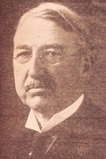
Torrence Huffman was a banker in Dayton, Ohio who loaned pasture land to the Wright brothers where they perfected their first airplanes and started the first pilot training school. "As their flights grew ever longer in September and October 1905, local citizens and area journalists finally realized that something extraordinary was taking place in the sky over Torrence Huffman’s pasture," notes aviation historian Tom Crouch. The 84-acre field has since been known as Huffman Prairie and is designated a National Historic Landmark and part of Ohio's Dayton Aviation Heritage National Historical Park.


