
Marquette is the county seat of Marquette County and the largest city in the Upper Peninsula of Michigan, United States. Located on the shores of Lake Superior, Marquette is a major port known primarily for shipping iron ore from the Marquette Iron Range. The city is partially surrounded by Marquette Township, but the two are administered autonomously.

Marquette County is a county located in the Upper Peninsula of the U.S. state of Michigan. As of the 2020 census, the population was 66,017. It is the most populous county in the Upper Peninsula. The county seat is Marquette. The county is named for Father Marquette, a Jesuit missionary. It was set off in 1843 and organized in 1851.

Gwinn is an unincorporated community in Marquette County in the U.S. state of Michigan. It is a census-designated place (CDP) for statistical purposes and has no legal status as an incorporated municipality. The population of the CDP was 1,784 at the 2020 census. The community is located within Forsyth Township.
Ishpeming is a city in Marquette County, Michigan, United States. Located in the Upper Peninsula, the population was 6,140 at the 2020 census, less than it was in the 1950s and 1960s when the Iron ore mines employed more workers. A statue of a Native American figure, erected in 1884 in the small town square, is referred to as "Old Ish".
Marquette Township is a charter township in Marquette County in the U.S. state of Michigan. The population was 4,140 at the 2020 census. The city of Marquette is located to the southeast of the township and is administratively autonomous.

Negaunee is a city in Marquette County in the U.S. state of Michigan. The population was 4,627 at the 2020 census. The city is located at the southwest corner of Negaunee Township, which is administratively separate, in the Upper Peninsula. The city is home to a luge track. The name "Negaunee" comes from an Anishinabemowin (Ojibwe) word nigani, meaning "foremost, in advance, leading," which was determined to be the closest Ojibwe translation for "pioneer". Within the city limits is Teal Lake.

Trowbridge Park is an unincorporated community in Marquette Township, Marquette County, in the U.S. state of Michigan. It is also a census-designated place (CDP) for statistical purposes and has no legal status as an incorporated municipality. The CDP had a population of 2,287 at the 2020 census. The community is located within Marquette Township and borders the city of Marquette on the east and north.

M-28 is an east–west state trunkline highway that traverses nearly all of the Upper Peninsula of the U.S. state of Michigan, from Wakefield to near Sault Ste. Marie in Bruce Township. Along with US Highway 2 (US 2), M-28 forms a pair of primary highways linking the Upper Peninsula from end to end, providing a major access route for traffic from Michigan and Canada along the southern shore of Lake Superior. M-28 is the longest state trunkline in Michigan numbered with the "M-" prefix at 290.373 miles (467.310 km). The entire highway is listed on the National Highway System, while three sections of M-28 are part of the Lake Superior Circle Tour. M-28 also carries two memorial highway designations along its route.
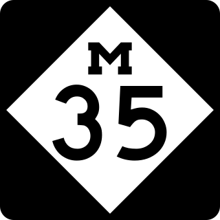
M-35 is a state trunkline highway in the Upper Peninsula (UP) of the US state of Michigan. It runs for 128 miles (206 km) in a general north–south direction and connects the cities of Menominee, Escanaba, and Negaunee. The southern section of M-35 in Menominee and Delta counties carries two additional designations; M-35 forms a segment of the Lake Michigan Circle Tour, and it is the UP Hidden Coast Recreational Heritage Trail, which is a part of what is now called the Pure Michigan Byways Program. Along the southern section, the highway is the closest trunkline to the Green Bay, a section of Lake Michigan. The northern section of the highway turns inland through sylvan areas of the UP, connecting rural portions of Delta and Marquette counties.

The Rapid is the public transit operator serving Grand Rapids, Michigan and its surrounding suburbs. The Rapid operates local service in urban areas in Kent County, and regional service to Ferris State University and Grand Valley State University in Mecosta and Ottawa Counties.

Marquette Sawyer Regional Airport, previously named Sawyer International Airport, is a county-owned, public-use airport in Marquette County, Michigan, United States. It is located 17 nautical miles south of the central business district of the city of Marquette. It is included in the Federal Aviation Administration (FAA) National Plan of Integrated Airport Systems for 2021–2025, in which it is categorized as a non-hub primary commercial service facility.

Business US Highway 41 was a state trunkline highway that served as a business loop off US 41 and M-28 in Marquette, Michigan, along Washington and Front streets. The streets serve the downtown area of Marquette and are bordered by several commercial properties and businesses. Those two streets originate with the early founding of the city in the middle of the 19th century. Jurisdiction over them was transferred to the city as part of a highway swap that resulted in the decommissioning of the trunkline in 2005. It was also previously co-designated Bus. M-28, mirroring the Bus. US 41/Bus. M-28 designation previously used along Bus. M-28 in Ishpeming and Negaunee. Washington and Front streets had been a part of the state highway system since the 1910s, and a part of the United States Numbered Highway System since 1926. The business loop designation dates back to the 1960s and was removed in 2005.
Business M-28 is a state trunkline highway serving as a business route that runs for approximately 4.9 miles (7.9 km) through the downtown districts of Ishpeming and Negaunee in the US state of Michigan. The trunkline provides a marked route for traffic diverting from U.S. Highway 41 (US 41) and M-28 through the two historic iron-mining communities. It is one of three business loops for M-numbered highways in the state of Michigan. There have previously been two other Bus. M-28 designations for highways in Newberry and Marquette.
Michigan's 1st congressional district is a United States congressional district that fully contains the 15 counties of the Upper Peninsula of Michigan and 20 counties of Northern Michigan in the Lower Peninsula. The district is currently represented by Republican Jack Bergman.
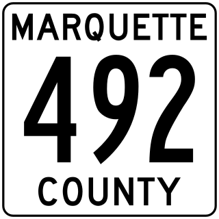
County Road 492 is a primary county road in Marquette County, Michigan. The road serves as an alternate route between Negaunee and Marquette. Several historic sites line the roadway as it runs south and parallel to the main highway, U.S. Highway 41 (US 41) and M-28, through the Marquette Iron Range in Michigan's Upper Peninsula. The path of the road runs near tracks of the Lake Superior and Ishpeming Railroad (LS&I). The locally created Iron Ore Heritage Trail will follow CR 492 through Eagle Mills and Morgan Meadows upon completion. The western terminus of the county road is on US 41/M-28 in Negaunee and the eastern end is in Marquette next to Lake Superior.
US Highway 41 (US 41) is a part of the United States Numbered Highway System that runs from Miami, Florida, to the Upper Peninsula of the US state of Michigan. In Michigan, it is a state trunkline highway that enters the state via the Interstate Bridge between Marinette, Wisconsin, and Menominee, Michigan. The 278.769 miles (448.635 km) of US 41 that lie within Michigan serve as a major conduit. Most of the highway is listed on the National Highway System. Various sections are rural two-lane highway, urbanized four-lane divided expressway and the Copper Country Trail National Scenic Byway. The northernmost community along the highway is Copper Harbor at the tip of the Keweenaw Peninsula. The trunkline ends at a cul-de-sac east of Fort Wilkins State Park after serving the Central Upper Peninsula and Copper Country regions of Michigan.
Negaunee Public Schools is a school district headquartered in Negaunee, Michigan.
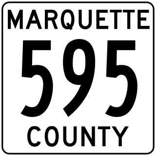
County Road 595 was a proposed primary county road in Marquette County in the US state of Michigan. The road would have provided access from the northern part of the county, near the Eagle Mine in Michigamme Township, to US Highway 41 (US 41) and M-28 in Humboldt Township. The approximately 21.5-mile-long (34.6 km) road would have been used primarily for commercial truck traffic hauling rock from the Eagle Mine to a processing facility south of US 41/M-28 in Humboldt Township. At present, such traffic has to use existing county roads which involves passing through the cities of Marquette, Negaunee, and Ishpeming. The northern end would have been northeast of the mine in Champion Township at an intersection with the Triple A Road.
