Harvey, Michigan

Last updated

Harvey, Michigan
Harvey (community), MI location.png
Location within Marquette County
USA Michigan location map.svg
Red pog.svg
Harvey
Usa edcp location map.svg
Red pog.svg
Harvey
Coordinates: 46°29′41″N87°21′16″W / 46.49472°N 87.35444°W / 46.49472; -87.35444
CountryUnited States
State Michigan
County Marquette
Townships Chocolay, Sands
Area
[1]
  Total7.31 sq mi (18.93 km2)
  Land6.74 sq mi (17.45 km2)
  Water0.57 sq mi (1.48 km2)
Elevation
650 ft (198 m)
Population
 (2020) [2]
  Total3,244
  Density481.59/sq mi (185.96/km2)
Time zone UTC-5 (Eastern (EST))
  Summer (DST) UTC-4 (EDT)
ZIP Code
49855 (Marquette)
Area code 906
FIPS code 26-37080 [3]
GNIS feature ID0627901 [4]

Harvey is a census-designated place (CDP) in Marquette County in the U.S. state of Michigan. The population was 3,244 as of the 2020 census, [2] up from 1,393 in 2010, before the CDP was enlarged by the Census Bureau. The CDP is located within Chocolay and Sands townships.

Contents

Originally called "Harvey Location", the community is a southwest suburb of Marquette at the junction of U.S. Route 41 and M-28.

Geography

The community is in eastern Marquette County, bordered to the northwest by the city of Marquette and to the northeast by Lake Superior. The Chocolay River forms the northern part of the eastern border of the community, from Cedar Creek to the river's mouth at Lake Superior. According to the United States Census Bureau, the CDP has a total area of 7.31 square miles (18.93 km2), of which 6.74 square miles (17.46 km2) are land and 0.57 square miles (1.48 km2), or 7.84%, are water. [1]

US Highwah 41 and State Highway M-28 pass through Harvey, joining in the center of town and heading northwest 5 miles (8 km) to the center of Marquette. US 41 leads southeast 52 miles (84 km) to Gladstone, while M-28 leads east 38 miles (61 km) to Munising.

Demographics

Historical population
CensusPop.Note
1980 1,341
1990 1,3772.7%
2000 1,321−4.1%
2010 1,3935.5%
2020 3,244132.9%
U.S. Decennial Census [5]

As of the census [3] of 2000, there were 1,321 people, 565 households, and 346 families residing in the CDP. The population density was 646.9 inhabitants per square mile (249.8/km2). There were 646 housing units at an average density of 316.4 per square mile (122.2/km2). The racial makeup of the CDP was 93.79% White, 1.06% African American, 2.42% Native American, 0.61% Asian, 0.38% from other races, and 1.74% from two or more races. Hispanic or Latino of any race were 0.61% of the population.

There were 565 households, out of which 33.1% had children under the age of 18 living with them, 46.2% were married couples living together, 9.9% had a female householder with no husband present, and 38.6% were non-families. 34.3% of all households were made up of individuals, and 10.3% had someone living alone who was 65 years of age or older. The average household size was 2.34 and the average family size was 3.00.

In the CDP, the population was spread out, with 25.8% under the age of 18, 8.4% from 18 to 24, 30.4% from 25 to 44, 24.1% from 45 to 64, and 11.3% who were 65 years of age or older. The median age was 37 years. For every 100 females, there were 103.9 males. For every 100 females age 18 and over, there were 102.5 males.

The median income for a household in the CDP was $37,321, and the median income for a family was $48,365. Males had a median income of $41,471 versus $25,536 for females. The per capita income for the CDP was $18,733. About 2.9% of families and 7.0% of the population were below the poverty line, including 1.3% of those under age 18 and none of those age 65 or over.

Related Research Articles

<span class="mw-page-title-main">Marquette County, Michigan</span> County in Michigan, United States

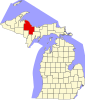
Marquette County is a county located in the Upper Peninsula of the U.S. state of Michigan. As of the 2020 Census, the population was 66,017. The county seat is Marquette. The county is named for Father Marquette, a Jesuit missionary. It was set off in 1843 and organized in 1851. Marquette County is the largest county in land area in Michigan, and the most populous county in the Upper Peninsula of Michigan.

<span class="mw-page-title-main">Central, Alaska</span> CDP in Alaska, United States

Central is a census-designated place (CDP) in Yukon-Koyukuk Census Area, Alaska, United States. At the 2010 census the population was 96, down from 134 in 2000. Every February, Central hosts a checkpoint for the long-distance Yukon Quest sled dog race.

<span class="mw-page-title-main">Lukachukai, Arizona</span> CDP in Apache County, Arizona

Lukachukai is a census-designated place (CDP) in Apache County, Arizona, United States. The population was 1,701 at the 2010 census. It is within the Navajo Nation.

<span class="mw-page-title-main">Pepeekeo, Hawaii</span> Census-designated place in Hawaii, U.S.

Pepeekeo is a census-designated place (CDP) in Hawaii County, Hawaii, United States. The population was 1,789 at the 2010 census, up from 1,697 at the 2000 census.

<span class="mw-page-title-main">Hubbard Lake, Alcona County, Michigan</span> Census-designated place & unincorporated community in Michigan, United States

Hubbard Lake is an unincorporated community and census-designated place (CDP) in Alcona County in the U.S. state of Michigan. The population was 857 at the 2020 census. Hubbard Lake occupies portions of Alcona, Caledonia, and Hawes township.

<span class="mw-page-title-main">Onota Township, Michigan</span> Civil township in Michigan, United States

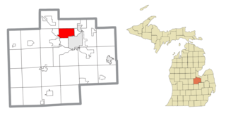
Onota Township is a civil township of Alger County in the U.S. state of Michigan. As of 2020, its population was 371.

<span class="mw-page-title-main">Benton Heights, Michigan</span> Census-designated place & unincorporated community in Michigan, United States

Benton Heights is an unincorporated community in Berrien County in the U.S. state of Michigan. It is also a census-designated place (CDP) for statistical purposes without any legal status as an incorporated municipality. Per the 2020 Census, the population was 3,652. The community is a part of Benton Charter Township and is adjacent to the city of Benton Harbor.

<span class="mw-page-title-main">Waverly, Michigan</span> Census-designated place & unincorporated community in Michigan, United States

Waverly is an unincorporated community in Eaton County in the U.S. state of Michigan. It is a census-designated place (CDP) for statistical purposes and has no legal status as a municipality. The population was 23,925 at the 2010 census, up from 16,194 at the 2000 census. Waverly is home to the Lansing Mall and Waverly Community Schools.

<span class="mw-page-title-main">Big Bay, Michigan</span> Census-designated place & unincorporated community in Michigan, United States

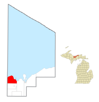
Big Bay is an unincorporated community in Marquette County of the U.S. state of Michigan. It is a census-designated place (CDP) for statistical purposes and does not have any legal status as an incorporated municipality. As of the 2020 census, the CDP had a population of 257, down from 319 in 2010. The community is located within Powell Township near the shore of Big Bay on Lake Superior.

<span class="mw-page-title-main">Chocolay Charter Township, Michigan</span> Charter township in Michigan, United States

Chocolay Township is a charter township in Marquette County in the U.S. state of Michigan. The population was 5,899 at the 2020 census. The township is named for the Chocolay River and is located on the shore of Lake Superior.

<span class="mw-page-title-main">Gwinn, Michigan</span> Census-designated place & unincorporated community in Michigan, United States

Gwinn is an unincorporated community in Marquette County in the U.S. state of Michigan. It is a census-designated place (CDP) for statistical purposes and has no legal status as an incorporated municipality. The population of the CDP was 1,784 at the 2020 census. The community is located within Forsyth Township.

<span class="mw-page-title-main">Michigamme, Michigan</span> Census-designated place & unincorporated community in Michigan, United States

Michigamme is an unincorporated community in Marquette County in the U.S. state of Michigan. It is located within Michigamme Township on the north shores of Lake Michigamme. For statistical purposes, the United States Census Bureau has defined Michigamme as a census-designated place (CDP). The CDP had a population of 255 at the 2020 census.

<span class="mw-page-title-main">Palmer, Michigan</span> Census-designated place & unincorporated community in Michigan, United States

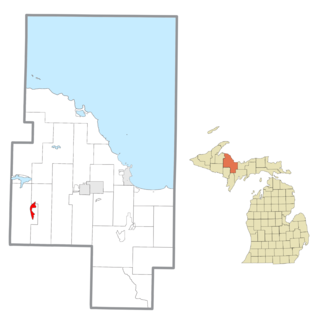
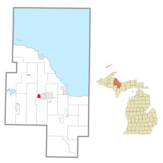
Palmer is an unincorporated community in Marquette County in the U.S. state of Michigan. It is a census-designated place (CDP) for statistical purposes and has no legal status as an incorporated municipality. The CDP had a population of 378 at the 2020 census. It is located within Richmond Township along M-35.

<span class="mw-page-title-main">Powell Township, Michigan</span> Civil township in Michigan, United States

Powell Township is a civil township of Marquette County in the U.S. state of Michigan. The population was 732 at the 2020 census.

<span class="mw-page-title-main">Republic, Michigan</span> Census-designated place & unincorporated community in Michigan, United States

Republic is an unincorporated community in Marquette County in the U.S. state of Michigan. It is also a census-designated place (CDP) for statistical purposes and no legal status as an incorporated municipality. The CDP had a population of 470 at the 2020 census, down from 570 in 2010. The community is located mostly within Republic Township with a small portion extending north into Humboldt Township.

<span class="mw-page-title-main">Trowbridge Park, Michigan</span> Census-designated place & unincorporated community in Michigan, United States

Trowbridge Park is an unincorporated community in Marquette Township, Marquette County, in the U.S. state of Michigan. It is also a census-designated place (CDP) for statistical purposes and has no legal status as an incorporated municipality. The CDP had a population of 2,287 at the 2020 census. The community is located within Marquette Township and borders the city of Marquette on the east and north.

<span class="mw-page-title-main">West Ishpeming, Michigan</span> Census-designated place & unincorporated community in Michigan, United States

West Ishpeming is an unincorporated community and census-designated place (CDP) in Marquette County in the U.S. state of Michigan. The population was 2,552 at the 2020 census. The community is located mostly within Ishpeming Township with a small portion extending south into Tilden Township.

<span class="mw-page-title-main">Saginaw Township North, Michigan</span> Place in Michigan, United States

Saginaw Township North is a former census-designated place (CDP) in Saginaw County in the U.S. state of Michigan. The CDP was defined for statistical purposes and had no legal status as an incorporated municipality. The population was 24,994 at the 2000 census. The community is located within Saginaw Charter Township and consists of most of the township north of State St., while Saginaw Township South is the area south of State St. This division was purely for statistical purposes and does not reflect any present or historical self-identification of the residents in these areas.

<span class="mw-page-title-main">Shields, Michigan</span> Census-designated place & unincorporated community in Michigan, United States

Shields is an unincorporated community in Thomas Township, Saginaw County in the U.S. state of Michigan. It is also a census-designated place (CDP) for statistical purposes, but with no legal status as an incorporated municipality. The population of the CDP was 7,035 at the 2020 census.

<span class="mw-page-title-main">Dunnstown, Pennsylvania</span> Census-designated place in Pennsylvania, United States

Dunnstown is a census-designated place (CDP) in Clinton County, Pennsylvania, United States. The population was 1,360 at the 2010 census.

References

  1. 1 2 "2022 U.S. Gazetteer Files: Michigan". United States Census Bureau. Retrieved August 16, 2023.
  2. 1 2 "P1. Race – Harvey CDP, Michigan: 2020 DEC Redistricting Data (PL 94-171)". U.S. Census Bureau. Retrieved August 16, 2023.
  3. 1 2 "U.S. Census website". United States Census Bureau . Retrieved January 31, 2008.
  4. U.S. Geological Survey Geographic Names Information System: Harvey, Michigan
  5. "Census of Population and Housing". Census.gov. Retrieved June 4, 2016.