Chocolay Township, Michigan | |
---|---|
Charter Township of Chocolay | |
Motto: "Superior Living ... Simply" | |
![]() Location within Marquette County (red) and the administered community of Harvey (pink) | |
Coordinates: 46°28′35″N87°18′44″W / 46.47639°N 87.31222°W | |
Country | ![]() |
State | ![]() |
County | Marquette |
Established | 1860 |
Named for | Chocolay River |
Government | |
• Supervisor | Richard Bohjanen |
• Clerk | Max Engle |
Area | |
• Total | 60.80 sq mi (157.5 km2) |
• Land | 58.98 sq mi (152.8 km2) |
• Water | 1.82 sq mi (4.7 km2) |
Elevation | 653 ft (199 m) |
Population | |
• Total | 5,899 |
• Density | 100.0/sq mi (38.6/km2) |
Time zone | UTC-5 (Eastern (EST)) |
• Summer (DST) | UTC-4 (EDT) |
ZIP Codes | |
Area code | 906 |
FIPS code | 26-103-15660 [3] |
GNIS feature ID | 1626081 [4] |
Website | www |
Chocolay Township ( /ˈtʃɒkəleɪ/ CHAH-kə-lay) is a charter township in Marquette County in the U.S. state of Michigan. The population was 5,899 at the 2020 census. [2] The township is named for the Chocolay River and is located on the shore of Lake Superior.
The township is in eastern Marquette County. It is bordered to the northwest by the city of Marquette, the county seat; to the west by Sands Township; to the south by West Branch and Skandia townships; to the east by Onota Township in Alger County; and to the north by Lake Superior.
According to the United States Census Bureau, the township has a total area of 60.80 square miles (157.47 km2), of which 58.98 square miles (152.76 km2) are land and 1.82 square miles (4.71 km2) (2.99%) are water. [1]
![]() | This section needs to be updated.(August 2020) |
Census | Pop. | Note | %± |
---|---|---|---|
1870 | 260 | — | |
1880 | 974 | 274.6% | |
1890 | 1,285 | 31.9% | |
1900 | 662 | −48.5% | |
1910 | 852 | 28.7% | |
1920 | 735 | −13.7% | |
1930 | 636 | −13.5% | |
1940 | 882 | 38.7% | |
1950 | 1,205 | 36.6% | |
1960 | 2,235 | 85.5% | |
1970 | 3,299 | 47.6% | |
1980 | 5,685 | 72.3% | |
1990 | 6,025 | 6.0% | |
2000 | 7,148 | 18.6% | |
2010 | 5,903 | −17.4% | |
2020 | 5,899 | −0.1% | |
U.S. Decennial Census [5] |
At the 2000 census, [3] there were 7,148 people, 2,324 households and 1,743 families residing in the township. The population density was 119.8 inhabitants per square mile (46.3/km2). There were 2,643 housing units at an average density of 44.3 per square mile (17.1/km2). The racial makeup, based on self-reporting, was 86.64% White, 8.66% African American, 2.01% Native American, 0.57% Asian, 0.07% Pacific Islander, 0.29% from other races, and 1.75% from two or more races. Hispanic or Latino of any race were 0.80% of the population. Based on self-reporting in Census 2000, 12.7% were of Finnish, 11.1% German, 10.5% French, 8.6% English, 7.6% Irish, 5.6% Swedish and 5.1% Italian ancestry.
There were 2,324 households, of which 35.8% had children under the age of 18 living with them, 63.6% were married couples living together, 7.4% had a female householder with no husband present, and 25.0% were non-families. 21.0% of all households were made up of individuals, and 6.0% had someone living alone who was 65 years of age or older. The average household size was 2.60 and the average family size was 3.00.
22.0% of the population were under the age of 18, 8.2% from 18 to 24, 34.0% from 25 to 44, 27.8% from 45 to 64, and 8.1% who were 65 years of age or older. The median age was 38 years. For every 100 females, there were 139.0 males. For every 100 females age 18 and over, there were 150.5 males.
The median household income was $49,438 and the median family income was $55,972. Males had a median income of $39,282 and females $27,500. The per capita income was $19,569. About 3.0% of families and 4.9% of the population were below the poverty line, including 5.0% of those under age 18 and 1.1% of those age 65 or over.
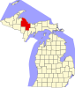
Baraga County is a county in the Upper Peninsula in the U.S. state of Michigan. As of the 2020 census, the population was 8,158, making it Michigan's fifth-least populous county. The county seat is L'Anse. The county is named after Bishop Frederic Baraga, a Catholic missionary who ministered to the Ojibwa Indians in the Michigan Territory.
Onota Township is a civil township of Alger County in the U.S. state of Michigan. As of 2020, its population was 371.
Rock River Township is a civil township of Alger County in the U.S. state of Michigan. The population was 1,231 at the 2020 census.
Lee Township is a civil township of Allegan County in the U.S. state of Michigan. The population was 4,015 at the 2010 census.
Ellis Township is a civil township of Cheboygan County in the U.S. state of Michigan. The population was 596 at the 2010 census.
Pickford Township is a civil township of Chippewa County in the U.S. state of Michigan. As of the 2010 census, the township population was 1,595.
Ely Township is a civil township of Marquette County in the U.S. state of Michigan. The population was 1,900 at the 2020 census.
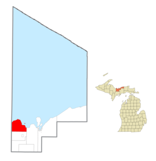
Ishpeming Township is a civil township of Marquette County in the U.S. state of Michigan. The population was 3,392 at the 2020 census. The city of Ishpeming is to the south, but the two are administered autonomously.
Powell Township is a civil township of Marquette County in the U.S. state of Michigan. The population was 732 at the 2020 census, down from 816 in 2010.
Turin Township is a civil township of Marquette County in the U.S. state of Michigan. As of the 2020 census, the township population was 110, down from 153 in 2010.
Wells Township is a civil township of Marquette County in the U.S. state of Michigan. As of the 2020 census, the township population was 213.
West Branch Township is a civil township of Marquette County in the U.S. state of Michigan. The population was 1,702 at the 2020 census.
Harris Township is a civil township of Menominee County in the U.S. state of Michigan. The population was 2,113 at the 2020 census.
Lake Township is a civil township of Roscommon County in the U.S. state of Michigan. The population was 1,119 at the 2020 census.
Latimore Township is a township in Adams County, Pennsylvania, United States. The population was 2,580 at the 2010 census.
Cambria Township is a township in Cambria County, Pennsylvania, United States. The population was 5,781 at the 2020 census. It is part of the Johnstown, Pennsylvania Metropolitan Statistical Area and geographically surrounds the borough of Ebensburg, the Cambria County seat.
Knox Township is a township that is located in Clarion County, Pennsylvania, United States. As of the 2020 census, the township population was 993, a decrease from the figure of 1,036 that was tabulated in 2010.
Middlesex Township is a township located in Cumberland County, Pennsylvania, United States. As of the 2010 census, the township had a total population of 7,040.
Paradise Township is a township that is located in east-central Lancaster County, Pennsylvania, United States. The population was 5,696 at the time of the 2020 census.
West Cocalico Township is a township that is located in northeastern Lancaster County, Pennsylvania, United States. The population was 7,491 at the time of the 2020 census.