La Prairie, Quebec

Last updated

La Prairie
Vieux-Laprairie-Chemin Saint-Jean (coin rue Saint-Laurent)-2022-06-03.jpg
Old La Prairie
Blason ville ca La Prairie.svg
Motto(s): 
Victor Hostium et Sui
(Latin for "Master of our Enemies and Oneself")
La Prairie Quebec location diagram.PNG
Location within Roussillon RCM
Canada Southern Quebec location map.png
Red pog.svg
La Prairie
Location in southern Quebec
Coordinates: 45°25′N73°30′W / 45.42°N 73.5°W / 45.42; -73.5 [1]
CountryFlag of Canada (Pantone).svg  Canada
Province Flag of Quebec.svg  Quebec
Region Montérégie
RCM Roussillon
ConstitutedMarch 30, 1846
Government
  MayorFrédéric Galantai
   Federal riding La Prairie
   Prov. riding La Prairie
Area
  Total54.80 km2 (21.16 sq mi)
  Land43.28 km2 (16.71 sq mi)
Population
 (2011) [4]
  Total23,357
  Density539.7/km2 (1,398/sq mi)
  Pop 2006–2011
Increase2.svg 7.3%
  Dwellings
9,346
Time zone UTC−5 (EST)
  Summer (DST) UTC−4 (EDT)
Postal code(s)
J5R
Area code(s) 450 and 579
Highways
Quebec Autoroute 15.svg A-15
Quebec Autoroute 30.svg A-30

Qc104.svg R-104
Qc132.svg R-132
Qc134.svg R-134
Qc217.svg R-217
Website www.ville.laprairie.qc.ca

La Prairie is an off-island suburb (south shore) of Montreal, in southwestern Quebec, Canada, at the confluence of the Saint-Jacques River and the Saint Lawrence River in the Regional County Municipality of Roussillon. The population as of the Canada 2011 Census was 23,357.

Contents

History

Plan of La Prairie de la Magdelaine in 1704 Plan de la Prairie de la Madeleine 1704.jpg
Plan of La Prairie de la Magdelaine in 1704
The old post office of La Prairie. La Prairie Post Office.jpg
The old post office of La Prairie.

French Jesuits were the first Europeans to occupy the area, which was named La Prairie de la Magdelaine but was also called François-Xavier-des-Prés. The land was given to the Jesuits by Jacques de La Ferté and the Company of One Hundred Associates in 1647. It is in La Prairie that the story Kateri Tekakwitha took place.

In 1668, the site was named Kentaké, the Iroquois name for "at the prairie". In the beginning of modern Quebec history, the territory of La Prairie would be visited on numerous occasions by Iroquois and English settlers from New York, among others at the time of the Anglo-Iroquois expedition of Pieter Schuyler in 1691, who commanded two battles on August 11, 1691.

The close of the Seven Years' War led to the 1763 treaty ending the French and Indian War. New France, sparsely-populated by indigenous peoples and descendants of French colonists, was ceded by France and divided into British colonies. The territory of La Prairie became part of the Province of Quebec (1763–1791) within the British Empire.

In 1845, the village of La Prairie was established. One year later, La Prairie-de-la-Magdelaine was established. La Prairie was the seat of Laprairie County (1855-1980s), [5] which included the parishes of La Prairie, Notre-Dame, Ste-Catherine, St-Constant, St-Isidore, St-Jacques-le-Mineur, St-Mathieu and St-Philippe. In 1909, La Prairie obtained official city status.

Historically, the city has been an important transportation hub, as it was the point of transfer between Montreal ferries and the land route to Saint-Jean-sur-Richelieu, gateway to Lake Champlain and the Hudson River. The first railway line in British North America, the Champlain and St. Lawrence Railroad, connected it with Saint-Jean-sur-Richelieu on July 21, 1836; [6] the railway ran over 16 miles (26 km). The construction of a rail line between La Prairie and Saint-Jean-sur-Richelieu would greatly accelerate the commercial development of the village. River transport equally played an important role in La Prairie's history.

Geography and climate

Like the rest of southwestern Quebec, La Prairie has hot summers and cold winters, for a generally temperate climate. Winters are cold and sometimes long (snow is usually present from mid-November to mid-April), with temperatures occasionally dipping below -30 °C, not counting the windchill. During snowstorms, snowfall frequently surpasses 40 centimeters. In the summer, temperatures sometimes exceed 30 °C.

Demographics

Historical Census Data – La Prairie, Quebec [7]
YearPop.±%
1991 15,237    
1996 17,128+12.4%
2001 18,896+10.3%
2006 21,763+15.2%
2011 23,357+7.3%

In the 2021 Census of Population conducted by Statistics Canada, La Prairie had a population of 26,406 living in 11,049 of its 11,309 total private dwellings, a change of 9.5% from its 2016 population of 24,110. With a land area of 43.47 km2 (16.78 sq mi), it had a population density of 607.5/km2 (1,573.3/sq mi) in 2021. [8]

Canada census – La Prairie community profile
2021 2011
Population26,406 (+9.5% from 2016)23,357 (+7.3% from 2006)
Land area43.47 km2 (16.78 sq mi)43.28 km2 (16.71 sq mi)
Population density607.4/km2 (1,573/sq mi)539.7/km2 (1,398/sq mi)
Median age42.8 (M: 42.4, F: 43.6)39.2 (M: 38.5, F: 39.7)
Private dwellings11,309 (total)  11,049 (occupied)9,346 (total) 
Median household income$91,000$74,167
References: 2021 [9] 2011 [10] earlier [11] [12]
Canada Census Mother Tongue – La Prairie, Quebec [7]
Mother tongue language
CensusTotal
French
English
French & English
Other
YearResponsesCountTrendPop %CountTrendPop %CountTrendPop %CountTrendPop %
2016
23,985
19,860Increase2.svg 0.4%82.8%990Increase2.svg 7.03%4.13%280Increase2.svg 14.29%1.16%2,610Increase2.svg 34.19%10.88%
2011
22,895
19,780Increase2.svg 4.1%86.39%925Increase2.svg 25.0%4.04%245Increase2.svg 113.0%1.07%1,945Increase2.svg 17.5%8.50%
2006
21,520
19,010Increase2.svg 13.5%88.34%740Increase2.svg 2.1%3.44%115Decrease2.svg 25.8%0.53%1,655Increase2.svg 89.1%7.69%
2001
18,500
16,745Increase2.svg 12.6%90.51%725Increase2.svg 26.1%3.92%155Decrease2.svg 13.9%0.84%875Decrease2.svg 18.6%4.73%
1996
16,700
14,870n/a89.04%575n/a3.44%180n/a1.08%1,075n/a6.44%

Transportation

Quebec Route 132 in La Prairie. Route 132 La Prairie.jpg
Quebec Route 132 in La Prairie.

The CIT Le Richelain provides commuter and local bus services.

Environment

In 2013, Grand Boisé conservation park is planned to be created and orchestrated by Nature-Action. The park would include Smithers' swamp, as well as, Hydro-Quebec's servitude area in which the western chorus frog, a vulnerable species in Quebec, is found in greatest numbers. There is a controversy involving the city housing development in that area which was supposed to be conserved integrally with high priority according to RCM of Roussillon 1990s' maps. Local environmental organisms, such as Vigile verte and Projet Rescousse, are denouncing the choice of that land for housing development. The debate is ongoing.

Education

The town has three high schools: l'École de la Magdeleine, a public French school which offers the International Baccalaureate (IB) Programme, Collège Jean de la Mennais, a private mixed French school and Saint-François-Xavier, a public French school.

The South Shore Protestant Regional School Board previously served the municipality. [13]

See also

Related Research Articles

<span class="mw-page-title-main">Longueuil</span> City in Quebec, Canada

Longueuil is a city in the province of Quebec, Canada. It is the seat of the Montérégie administrative region and the central city of the urban agglomeration of Longueuil. It sits on the south shore of the Saint Lawrence River directly across from Montreal. The population as of the Canada 2016 Census totalled 239,700, making it Montreal's second largest suburb, the fifth most populous city in Quebec and twentieth largest in Canada.

<span class="mw-page-title-main">Saint-Jean-sur-Richelieu</span> City in Quebec, Canada

Saint-Jean-sur-Richelieu is a city in eastern Montérégie in the Canadian province of Quebec, about 40 kilometres (25 mi) southeast of Montreal. It is situated on both the west and east banks of the Richelieu River at the northernmost navigable point of Lake Champlain. As of December 2019, the population of Saint-Jean-sur-Richelieu was 98,036.

<span class="mw-page-title-main">Richelieu River</span> River in Quebec, Canada; right tributary of the St. Lawrence

The Richelieu River is a river of Quebec, Canada, and a major right-bank tributary of the St. Lawrence River. It rises at Lake Champlain, from which it flows northward through Quebec and empties into the St. Lawrence. It was formerly known by the French as the Iroquois River and the Chambly River, and was named for Cardinal Richelieu, the powerful minister under Louis XIII.

<span class="mw-page-title-main">Saint-Hyacinthe</span> City in Quebec, Canada

Saint-Hyacinthe is a city in southwestern Quebec east of Montreal on the Yamaska River. The population as of the 2021 Canadian census was 57,239. The city is located in Les Maskoutains Regional County Municipality of the Montérégie region, and is traversed by the Yamaska River. Quebec Autoroute 20 runs perpendicular to the river. Saint-Hyacinthe is the seat of the judicial district of the same name.

<span class="mw-page-title-main">La Vallée-du-Richelieu Regional County Municipality</span> Regional county municipality in Quebec, Canada

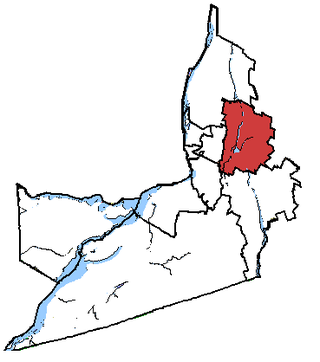
La Vallée-du-Richelieu(The Valley of the Richelieu) is a regional county municipality in the Montérégie region in southwestern Quebec, Canada. Its seat is McMasterville.

<span class="mw-page-title-main">Brossard</span> City in Quebec, Canada

Brossard is a municipality in the Montérégie region of Quebec, Canada and is part of the Greater Montreal area. According to the 2021 census, Brossard's population was 91,525. It shares powers with the urban agglomeration of Longueuil and was a borough of the municipality of Longueuil from 2002 to 2006.

<span class="mw-page-title-main">Saint-Constant, Quebec</span> City in Quebec, Canada

Saint-Constant is a city in southwestern Quebec, Canada. It is located on the south shore of Montreal in the Roussillon Regional County Municipality of the Montérégie region. The population as of the Canada 2016 Census was 27,359.

<span class="mw-page-title-main">Chambly, Quebec</span> City in Quebec, Canada

Chambly is an off-island suburb of Montreal in southwestern Quebec, Canada. It is located in the Montérégie region, inland from the South Shore of the Saint Lawrence River.

<span class="mw-page-title-main">Sainte-Catherine, Quebec</span> City in Quebec, Canada

Sainte-Catherine is an off-island suburb of Montreal, in southwestern Quebec, Canada, on the St. Lawrence River in the Regional County Municipality of Roussillon. The population as of the Canada 2011 Census was 16,762.

<span class="mw-page-title-main">Mont-Saint-Hilaire</span> City in Quebec, Canada

Mont-Saint-Hilaire is a suburb of Montreal on the South Shore of southeastern Quebec, Canada, on the Richelieu River in the Regional County Municipality of La Vallée-du-Richelieu. The population as of the Canada 2011 Census was 18,200. The city is named after the Mont Saint-Hilaire.

<span class="mw-page-title-main">Montérégie</span> Administrative region in Quebec, Canada

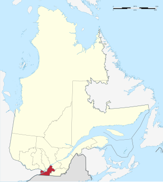
Montérégie is an administrative region in the southwest part of Quebec. It includes the cities of Boucherville, Brossard, Châteauguay, Longueuil, Saint-Hyacinthe, Saint-Jean-sur-Richelieu, Salaberry-de-Valleyfield and Vaudreuil-Dorion.

<span class="mw-page-title-main">Candiac, Quebec</span> City in Quebec, Canada

Candiac is a suburb of Montreal, in the Canadian province of Quebec; it is located on the South Shore of the Saint Lawrence River opposite Montreal near La Prairie. The population as of the Canada 2021 Census was 22,997.

<span class="mw-page-title-main">Chambly—Borduas</span> Former federal electoral district in the province of Quebec, Canada

Chambly—Borduas was a federal electoral district in the province of Quebec, Canada, that was represented in the House of Commons of Canada from 1867 to 1935, and from 1968 to 2015. Created by the British North America Act of 1867, its name was changed in 1893 to "Chambly—Verchères". In 1933, it was amalgamated into the Chambly—Rouville and Richelieu—Verchères electoral districts. The district was re-created in 1966 from Chambly—Rouville, Châteauguay—Huntingdon—Laprairie, and Richelieu—Verchères. Its name was changed in 2003 to "Chambly—Borduas". In 2015, most of the district became part of Beloeil—Chambly, while small parts of it joined Montarville and Pierre-Boucher—Les Patriotes—Verchères.

<span class="mw-page-title-main">Saint-Jean (federal electoral district)</span> Federal electoral district in Quebec, Canada

Saint-Jean is a federal electoral district in Quebec, Canada, that has been represented in the House of Commons of Canada since 1968.

<span class="mw-page-title-main">Saint-Charles-sur-Richelieu, Quebec</span> Municipality in Quebec, Canada

Saint-Charles-sur-Richelieu is a municipality in southwestern Quebec, Canada, on the Richelieu River in the Regional County Municipality of La Vallée-du-Richelieu. The population as of the Canada 2011 Census was 1,643.

<span class="mw-page-title-main">Lacolle, Quebec</span> Municipality in Quebec, Canada

Lacolle is a municipality in southern Quebec, Canada, located in the administrative area of the Montérégie, on the Canada–United States border. The population as of the Canada 2011 Census was 2,680. The Lacolle River runs eastward through the middle of the town and empties in Richelieu River. More people cross the border illegally from the United States there than at any other point. Almost nineteen thousand people were detained in 2017. The nearest town across the border is Champlain, New York.

<span class="mw-page-title-main">Saint-Philippe, Quebec</span> City in Quebec, Canada

Saint-Philippe is a city located in Roussillon Regional County Municipality in the Montérégie region of Quebec, Canada. It was established on July 1, 1855. The population as of the Canada 2021 Census was 7,597.

<span class="mw-page-title-main">Saint-Blaise-sur-Richelieu, Quebec</span> Municipality in Quebec, Canada

Saint-Blaise-sur-Richelieu is a municipality in the Canadian province of Quebec. The population as of the Canada 2016 Census was 2,066. The town was founded in 1892.

<span class="mw-page-title-main">Saint-Mathias-sur-Richelieu</span> Municipality in Quebec, Canada

Saint-Mathias-sur-Richelieu is a municipality in the Canadian province of Quebec. It is located within the Rouville Regional County Municipality in the Montérégie region on the Richelieu River. The population as of the Canada 2011 Census was 4,618.
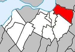
<span class="mw-page-title-main">Saint-Prime, Quebec</span> Municipality in Quebec, Canada

Saint-Prime is a municipality in Quebec, Canada, located within the regional county municipality of Le Domaine-du-Roy. The municipality had a population of 2,758 as of the Canada 2011 Census, and a land area of 147.16 km2.

References

  1. "Reference number 34269 in Banque de noms de lieux du Québec". toponymie.gouv.qc.ca (in French). Commission de toponymie du Québec.
  2. 1 2 "Ministère des Affaires municipales, des Régions et de l'Occupation du territoire: La Prairie". Mamrot.gouv.qc.ca. 1909-05-07. Archived from the original on 2013-12-13. Retrieved 2013-06-18.
  3. "Parliament of Canada Federal Riding History: BROSSARD-LA PRAIRIE (Quebec)". .parl.gc.ca. Retrieved 2013-06-18.
  4. 1 2 "2011 Statistics Canada Census Profile: La Prairie, Quebec". 2.statcan.gc.ca. Retrieved 2013-06-18.
  5. Laprairie County, Quebec - Genealogy, accessed April 2018.
  6. Ayre, Robert (1932-01-01). "When the Railway Came to Canada". Queen's Quarterly. 39. ProQuest   1296948193.
  7. 1 2 Statistics Canada: 1996, 2001, 2006, 2011, 2016census
  8. "Population and dwelling counts: Canada, provinces and territories, and census subdivisions (municipalities), Quebec". Statistics Canada. February 9, 2022. Retrieved August 29, 2022.
  9. "2021 Community Profiles". 2021 Canadian Census . Statistics Canada. February 4, 2022. Retrieved 2023-10-19.
  10. "2011 Community Profiles". 2011 Canadian Census . Statistics Canada. March 21, 2019. Retrieved 2014-02-21.
  11. "2006 Community Profiles". 2006 Canadian Census . Statistics Canada. August 20, 2019.
  12. "2001 Community Profiles". 2001 Canadian Census . Statistics Canada. July 18, 2021.
  13. King, M.J. (Chairperson of the board). "South Shore Protestant Regional School Board" (St. Johns, PQ). The News and Eastern Townships Advocate . Volume 119, No. 5. Thursday December 16, 1965. p. 2. Retrieved from Google News on November 23, 2014.