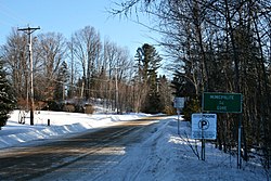
The Gore Township was established in 1840, named after Francis Gore (1769–1852), Lieutenant-Governor of Upper Canada from 1806 to 1811 and from 1815 to 1817. It was colonized by Scottish and Irish settlers, such as Robert Smith and James Stephenson.[1][4]
In 1845, the Gore Municipality was formed, abolished two years later, and restored in 1855. In 1853 it had about 1000 inhabitants but this dropped to about 800 people ten years later, almost all of Irish origin. The Gore Post Office operated between 1898 and 1958.[1]
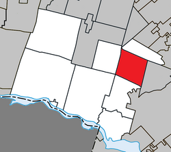
Geography
Located in the Laurentian Mountains, the township consists of rugged Canadian Shield with an elevation varying between 168 meters (551ft) and 427 meters (1,401ft). The terrain is characterized by forested mountains and numerous streams and lakes. Notable lakes include Barron, Hughes, Chevreuil, aux Oiseaux, Solar, Caroline, Evans, Dawson, Clark, Grace, Sugarloaf, Clair, and Carruthers; many of them have been entirely developed over the years, but there still remain many with little or no construction to date.[5]
The majority of its territory is covered by old-growth forests with a wide variety of species both deciduous and coniferous, such as birch, poplar, sugar maple, beech, white pine, fir, spruce, hemlock, and cedar.[5]
Demographics
In the 2021 Census of Population conducted by Statistics Canada, Gore had a population of 2,283 living in 1,124 of its 1,615 total private dwellings, a change of 19.9% from its 2016 population of 1,904. With a land area of 90.04km2 (34.76sqmi), it had a population density of 25.4/km2 (65.7/sqmi) in 2021.[3]
This page is based on this Wikipedia article Text is available under the CC BY-SA 4.0 license; additional terms may apply. Images, videos and audio are available under their respective licenses.