Grenville | |
---|---|
| |
![]() Location within Argenteuil RCM | |
Coordinates: 45°38′N74°36′W / 45.633°N 74.600°W [1] | |
Country | Canada |
Province | Quebec |
Region | Laurentides |
RCM | Argenteuil |
Settled | 1810 |
Constituted | January 1, 1876 |
Government | |
• Mayor | Pierre Thauvette |
• Federal riding | Argenteuil—La Petite-Nation |
• Prov. riding | Argenteuil |
Area | |
• Total | 3.14 km2 (1.21 sq mi) |
• Land | 2.82 km2 (1.09 sq mi) |
Population (2021) [3] | |
• Total | 1,816 |
• Density | 644.6/km2 (1,670/sq mi) |
• Pop 2016-2021 | ![]() |
• Dwellings | 951 |
Time zone | UTC−5 (EST) |
• Summer (DST) | UTC−4 (EDT) |
Postal code(s) | |
Area code | 819 |
Highways | ![]() |
Website | grenville |
Grenville is a village municipality in the Argenteuil Regional County Municipality of the Laurentides region of Quebec, Canada. It is located opposite Hawkesbury, Ontario, on the Ottawa River.
Although Grenville was already shown on the Gale and Duberger Map of 1795, it was not until January 28, 1808, that Grenville Township was officially established; the township's name commemorated Lord George Grenville. Two years later, in 1810, the first French and English settlers arrived in the area. [4] [5]
Its strategic location on the Ottawa River and the construction of the Carillon Canal in 1819 led to the town's real growth. [6] In 1826 the first general store opened and in 1828, the first school. In 1830 "Kingsey" sawmill was built, and a flour mill was added in 1838. In 1857 construction began on the Carillon and Grenville Railway, which was completed six years later. [5]
In 1861 the village and its surroundings had about 900 inhabitants. On January 1, 1876, the Village Municipality of Grenville was formed at which time it exceeded one thousand persons. [6]
In 1910 the Carillon and Grenville Railway was abandoned and later on dismantled. [5]
The Grenville Canal, the Chute-à-Blondeau Canal, and the Carillon Canal were built to navigate the Long Sault Rapids on the Ottawa River which stretched for 21 kilometres (13 mi) from Carillon to Grenville. The impetus for these canals was the War of 1812. During this war, attacks along the Saint Lawrence River jeopardized the communication lines between Kingston and Montreal, the two main military positions of Upper and Lower Canada. The Ottawa River Canal and the Rideau Canal were thus designed as an alternative military supply route in the event of war with the Americans. [7] [8]
Work on the canal began in 1818 with the construction of a storage warehouse. In 1819 Captain Henry Vernet of the Royal Engineers arrived from Britain to lead the construction of the project. Hundreds of Irish immigrants and French Canadians were used to excavate the canal under the direction of a hundred British soldiers. In 1833 the Grenville Canal was completed with an original length of 9.5 kilometres (5.9 mi) and the entire network on the Ottawa River, including the 11 locks, was not fully completed until about 1843. [9]
The military requirements decided all aspects of the canal. The size of the locks were set to 134 feet (41 m) long, 33 feet (10 m) wide, and only 5 feet (1.5 m) deep at the thresholds. These dimensions, standards adopted for military use, were insufficient for any commercial use. [9] Forestry had become the main economic activity in this region, and from 1867, local business people demanded that the government carry out improvements to the network because the original canal network had become outdated. In 1870 the Canals Commission recommended making the Ottawa River deeper between Lachine and Ottawa. Therefore, between 1873 and 1882, the Grenville and Carillon Canals were enlarged (the dam built upstream from the village of Carillon raised the level of the Ottawa River at Chute-à-Blondeau, making the need for a lock there no longer necessary). [7]
Further changes were made from 1959 to 1963 with the construction of the Carillon hydroelectric dam and a modern 20 metres (66 ft) high lock at Carillon. This work substantially and irreversibly changed the canal network. The dam raised the water level by over 62 feet (19 m) at Carillon and over 9 feet (2.7 m) at Grenville. The new water level flooded Greece's Point and its surroundings several feet underwater and inundated the rapids of Long-Sault, transforming them into calm water. [9] Shortly afterwards, the steel swing bridge and canal locks were dismantled. [5]
|
| ||||||||||||||||||||||||||||||||||||
Source: Statistics Canada [10] |
In the 2021 Census of Population conducted by Statistics Canada, Grenville had a population of 1,816 living in 903 of its 951 total private dwellings, a change of 6.1% from its 2016 population of 1,711. With a land area of 2.82 km2 (1.09 sq mi), it had a population density of 644.0/km2 (1,667.9/sq mi) in 2021. [11]
2021 | 2016 | 2011 | |
---|---|---|---|
Population | 1,816 (+6.1% from 2016) | 1,711 (+8.5% from 2011) | 1,577 (+12.8% from 2006) |
Land area | 2.82 km2 (1.09 sq mi) | 2.87 km2 (1.11 sq mi) | 2.81 km2 (1.08 sq mi) |
Population density | 644.6/km2 (1,670/sq mi) | 597.2/km2 (1,547/sq mi) | 560.4/km2 (1,451/sq mi) |
Median age | 47.2 (M: 46.0, F: 48.8) | 42.8 (M: 42.9, F: 42.6) | 42.3 (M: 41.3, F: 43.0) |
Private dwellings | 951 (total) 903 (occupied) | 862 (total) | 738 (total) |
Median household income | $55,200 | $44,971 | $n/a |
Mother tongue (2006): [17]
List of former mayors:
![]() |
The Commission scolaire de la Rivière-du-Nord operates French-language public schools. [18]
The Sir Wilfrid Laurier School Board operates the English-language public schools.
Argenteuil is a regional county municipality located in the Laurentides region of Quebec, Canada. Its seat is Lachute.
Hawkesbury is a town in the United Counties of Prescott and Russell in Eastern Ontario, Canada. Hawkesbury is the third most bilingual town in Ontario, with about 70% of its inhabitants being fluent in English and French. Franco-Ontarians make up 89% of the population.
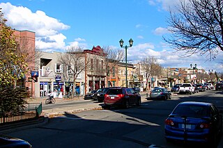
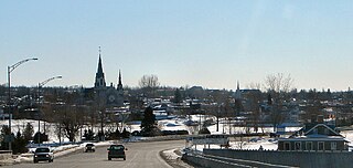
Lachute is a town in southwest Quebec, Canada, 62 km (39 mi) northwest of Montreal, on the Rivière du Nord, a tributary of the Ottawa River, and west of Mirabel International Airport. It is located on Autoroute 50, at the junctions of Quebec Provincial Highways Route 148, Route 158, and Secondary Highways 327 and 329.
Brownsburg-Chatham is a municipality in the Laurentides region of Quebec, Canada, part of the Argenteuil Regional County Municipality.
Papineauville is a town and municipality in the Outaouais region of Quebec, Canada. It is the seat of the Papineau Regional County Municipality. In 2001 its population was 2247.
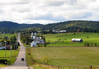
Grenville-sur-la-Rouge is a municipality in the Argenteuil Regional County Municipality in the Laurentides region of Quebec, Canada. It is a predominantly Francophone community situated along the southern border of Quebec between Montreal and Ottawa.
Waltham, also known as Waltham Station is a village and municipality in the Outaouais region, Quebec, Canada, part of the Pontiac Regional County Municipality. It is located at the mouth of the Noire River, along the north shore of the Ottawa River at Allumette Island.
L'Isle-aux-Allumettes is a municipality in the Outaouais region, part of the Pontiac Regional County Municipality, Quebec, Canada. The municipality consists primarily of Allumette Island, and also includes Morrison Island, Marcotte Island, and some minor islets, all in the Ottawa River north of Pembroke.
Gore is a township municipality in the Canadian province of Quebec, located within the Argenteuil Regional County Municipality. Its main community is Lakefield.
Harrington is a township municipality in the Laurentides region of Quebec, Canada, part of the Argenteuil Regional County Municipality. It is located in the Laurentian Mountains, about 40 kilometres (25 mi) north-west of Lachute.
Wentworth is a township municipality in the Laurentides region of Quebec, Canada, part of the Argenteuil Regional County Municipality, north-west of Lachute.
The Carillon generating station is a hydroelectric power station on the Ottawa River near Carillon, Quebec, Canada. Built between 1959 and 1964, it is managed and operated by Hydro-Québec. It is a run-of-river generating station with an installed capacity of 752 megawatts (1,008,000 hp), a head of 17.99 meters (59.0 ft), and a reservoir of 26 square kilometers (10 sq mi). The dam spans the river between Carillon and Pointe-Fortune, Quebec.
Montcalm is a municipality in the Les Laurentides Regional County Municipality of Quebec southeast of Mont-Tremblant. The main population centre in Montcalm is the village of Weir.
Chénéville is a town and municipality in the Outaouais region of Quebec, Canada, part of the Papineau Regional County Municipality.
Notre-Dame-de-la-Paix is a town and municipality in the Outaouais region of Quebec, Canada, part of the Papineau Regional County Municipality.
Boileau is a village and municipality in the Outaouais region of Quebec, Canada, part of the Papineau Regional County Municipality. The municipality was known as Ponsonby until 1993.
The Carillon Canal is a National Historic Site of Canada in Saint-André-d'Argenteuil, Quebec. It preserves the historic Carillon Canal that was first built in the 1830s to facilitate travel on the Ottawa River. It is a prominent heritage site and recreation area, visited annually by 20,000 pleasure boaters and 30,000 people who use its riverside park.
Saint-André-d'Argenteuil is a municipality in the Laurentides region of Quebec, Canada, part of the Argenteuil Regional County Municipality. It is located along the Ottawa River, just south of Lachute.
Mille-Isles is a municipality in the Laurentides region of Quebec, Canada, part of the Argenteuil Regional County Municipality, west of Saint-Jérôme.
Longue-Rive is a municipality located on the north shore of the maritime estuary of the St. Lawrence River, in Côte-Nord region, Quebec, Canada.