
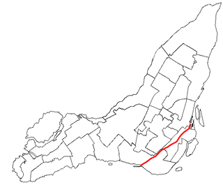
The St. Lawrence Seaway is a system of locks, canals, and channels in Canada and the United States that permits oceangoing vessels to travel from the Atlantic Ocean to the Great Lakes of North America, as far inland as Duluth, Minnesota, at the western end of Lake Superior. The seaway is named for the St. Lawrence River, which flows from Lake Ontario to the Atlantic Ocean. Legally, the seaway extends from Montreal, Quebec, to Lake Erie, and includes the Welland Canal. Ships from the Atlantic Ocean are able to reach ports in all five of the Great Lakes.

The Island of Montreal is a large island in southwestern Quebec, Canada, that is the site of a number of municipalities including most of the city of Montreal and is the most populous island in Canada. It is the main island of the Hochelaga Archipelago at the confluence of the Saint Lawrence and Ottawa rivers.

Lake Saint-Louis is a lake in southwestern Quebec, Canada, at the confluence of the Saint Lawrence and Ottawa Rivers. The Saint Lawrence Seaway passes through the lake.

A lock is a device used for raising and lowering boats, ships and other watercraft between stretches of water of different levels on river and canal waterways. The distinguishing feature of a lock is a fixed chamber in which the water level can be varied; whereas in a caisson lock, a boat lift, or on a canal inclined plane, it is the chamber itself that rises and falls.

Sainte-Anne-de-Bellevue is an on-island suburb located at the western tip of the Island of Montreal in southwestern Quebec, Canada. It is the second oldest community in Montreal's West Island, having been founded as a parish in 1703. The oldest, Dorval, was founded in 1667.

The Rideau Canal, also known unofficially as the Rideau Waterway, connects Canada's capital city of Ottawa, Ontario, to Lake Ontario and the Saint Lawrence River at Kingston. It is 202 kilometres long. The name Rideau, French for "curtain", is derived from the curtain-like appearance of the Rideau River's twin waterfalls where they join the Ottawa River. The canal system uses sections of two rivers, the Rideau and the Cataraqui, as well as several lakes. Parks Canada operates the Rideau Canal.

The Trent–Severn Waterway is a 386-kilometre-long (240 mi) canal route connecting Lake Ontario at Trenton to Georgian Bay, Lake Huron, at Port Severn. Its major natural waterways include the Trent River, Otonabee River, Kawartha Lakes, Lake Simcoe, Lake Couchiching and Severn River. Its scenic, meandering route has been called "one of the finest interconnected systems of navigation in the world".

The Richelieu River is a river of Quebec, Canada, and a major right-bank tributary of the St. Lawrence River. It rises at Lake Champlain, from which it flows northward through Quebec and empties into the St. Lawrence. It was formerly known by the French as the Iroquois River and the Chambly River, and was named for Cardinal Richelieu, the powerful minister under Louis XIII.

The Soo Locks are a set of parallel locks, operated and maintained by the United States Army Corps of Engineers, Detroit District, that enable ships to travel between Lake Superior and the lower Great Lakes. They are located on the St. Marys River between Lake Superior and Lake Huron, between the Upper Peninsula of the U.S. state of Michigan and the Canadian province of Ontario. They bypass the rapids of the river, where the water falls 21 ft (6.4 m). The locks pass an average of 10,000 ships per year, despite being closed during the winter from January through March, when ice shuts down shipping on the Great Lakes. The winter closure period is used to inspect and maintain the locks.
The Lachine Canal is a canal passing through the southwestern part of the Island of Montreal, Quebec, Canada, running 14.5 kilometres from the Old Port of Montreal to Lake Saint-Louis, through the boroughs of Lachine, Lasalle and Sud-Ouest.

The Chambly Canal is a National Historic Site of Canada in the Province of Quebec, running along the Richelieu River past Saint-Jean-sur-Richelieu, Carignan, and Chambly. Building commenced in 1831 and the canal opened in 1843. It served as a major commercial route during a time of heightened trade between the United States and Canada. Trade dwindled after World War I, and as of the 1970s, traffic has been replaced by recreational vessels.
St. Peter's is a small incorporated village located on Cape Breton Island in Richmond County, Nova Scotia, Canada.

The Volga–Baltic Waterway, formerly known as the Mariinsk Canal System, is a series of canals and rivers in Russia which link the Volga with the Baltic Sea via the Neva. Like the Volga–Don Canal, it connects the biggest lake on Earth, the Caspian Sea, to the World Ocean. Its overall length between Cherepovets and Lake Onega is 368 kilometres (229 mi).

The Sault Ste. Marie Canal is a National Historic Site in Sault Ste. Marie, Ontario, and is part of the national park system, managed by Parks Canada. It includes a lock to bypass the rapids on the St. Marys River.
The South Hadley Canal was a canal along the Connecticut River in South Hadley, Massachusetts. It was the earliest navigable canal in the United States, with operation commencing in 1795. It has been listed on the National Register of Historic Places as the South Hadley Canal Historic District.

Coteau-du-Lac Canal is an 18th-century military canal in Canada located at the junction of the Delisle and Saint Lawrence Rivers in Quebec. The canal was the first work of its kind in North America, and is a National Historic Site of Canada, which also includes the remains of a fort and reconstructed blockhouse. It is located in the town of Coteau-du-Lac in Vaudreuil-Soulanges Regional County Municipality.

The Soulanges Canal is an abandoned shipping canal in Quebec, Canada. It follows the north shore of the Saint Lawrence River between Pointe-des-Cascades and Coteaux-Landing, bypassing the rapids between Lake Saint-Louis and Lake Saint-Francis. In between, it passes through the towns of Les Cèdres and Coteau-du-Lac. It superseded the first Beauharnois Canal which was on the south shore of the Saint Lawrence. It is 23 kilometres (14 mi) long and had a 4.3-metre (14.1 ft) draught. Five locks measuring 85.3 m × 14 m give a total rise of 25 metres (82 ft).

Grenville is a village municipality in the Argenteuil Regional County Municipality of the Laurentides region of Quebec, Canada. It is located opposite Hawkesbury, Ontario, on the Ottawa River.

The Carillon Canal is a National Historic Site of Canada in Saint-André-d'Argenteuil, Quebec. It preserves the historic Carillon Canal that was first built in the 1830s to facilitate travel on the Ottawa River. It is a prominent heritage site and recreation area, visited annually by 20,000 pleasure boaters and 30,000 people who use its riverside park.

