Lac-Ernest, Quebec

Last updated
Lac-Ernest
Lac Ernest a l'aurore.jpg
Ernest Lake at dawn
Lac-Ernest Quebec location diagram.png
Location within Antoine-Labelle RCM.
Canada Central Quebec location map.png
Red pog.svg
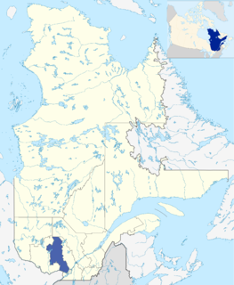
Lac-Ernest
Location in central Quebec.
Coordinates: 46°11′N75°12′W / 46.183°N 75.200°W / 46.183; -75.200 Coordinates: 46°11′N75°12′W / 46.183°N 75.200°W / 46.183; -75.200 [1]
CountryFlag of Canada (Pantone).svg  Canada
Province Flag of Quebec.svg  Quebec
Region Laurentides
RCM Antoine-Labelle
ConstitutedJanuary 1, 1986
Government
[2]
   Federal riding Laurentides—Labelle
   Prov. riding Labelle
Area
  Total381.50 km2 (147.30 sq mi)
  Land343.36 km2 (132.57 sq mi)
Population
 (2011) [3]
  Total0
  Density0.0/km2 (0/sq mi)
  Pop 2006-2011
Steady2.svg 0.0%
  Dwellings
0
Time zone UTC−5 (EST)
  Summer (DST) UTC−4 (EDT)
HighwaysNo major routes

Lac-Ernest is an unorganized territory in the Laurentides region of Quebec, Canada. It is almost entirely within the Papineau-Labelle Wildlife Reserve.

Laurentides Administrative region in Quebec, Canada

The Laurentides is a region of Quebec. While it is often called the Laurentians in English, the region includes only part of the Laurentian mountains. It has a total land area of 20,744.29 km2 (8,009.42 sq mi) and a 2011 census population of 555,614 inhabitants.

Papineau-Labelle Wildlife Reserve

Papineau-Labelle Wildlife Reserve is a reserve in the Laurentian Mountains of Quebec, Canada, stretching across the Laurentides and Outaouais regions.

Contents

History

In the early 1920s, the Singer Company, manufacturer best known for its sewing machines, began logging the area. This company built a railway from Thurso to southern Lake Montjoie in Lac-Ernest territory. Here a vast logging camp, known as "Camp 27", was established where logs were accumulated as far as the eye could see. In 1964, the MacLaren Company succeeded Singer and used the railroad until 1980 when it was dismantled and now functions as a rail trail. [4]

Singer Corporation American manufacturer of sewing machines

Singer Corporation is an American manufacturer of domestic sewing machines, first established as I. M. Singer & Co. in 1851 by Isaac Merritt Singer with New York lawyer Edward Clark. Best known for its sewing machines, it was renamed Singer Manufacturing Company in 1865, then The Singer Company in 1963. It is based in La Vergne, Tennessee, near Nashville. Its first large factory for mass production was built in Elizabeth, New Jersey, in 1863.

Thurso, Quebec City in Quebec, Canada

Thurso is a city in Papineau Regional County Municipality in the Outaouais region of western Quebec, Canada. It is located on the Ottawa River, and is within Canada's National Capital Region. Its population was 2,455 as of the Canada 2011 Census.

Rail trail railroad bed converted to a recreational trail

A rail trail is the conversion of a disused railway track into a multi-use path, typically for walking, cycling and sometimes horse riding and snowmobiling. The characteristics of abandoned railways—flat, long, frequently running through historical areas—are appealing for various developments. The term sometimes also covers trails running alongside working railways; these are called "rails with trails". Some shared trails are segregated, with the segregation achieved with or without separation. Many rail trails are long-distance trails.

Demographics

Population trend: [5]

See also

Related Research Articles

Antoine-Labelle Regional County Municipality Regional county municipality in Quebec, Canada

Antoine-Labelle is a regional county municipality located in the Laurentides region of Quebec, Canada. Its seat is Mont-Laurier. It is named for Antoine Labelle.

Rivière-Héva Municipality in Quebec, Canada

Rivière-Héva is a municipality in northwestern Quebec, Canada in the La Vallée-de-l'Or Regional County Municipality. It is named after the Héva River that flows through the municipality.

Dépôt-Échouani, Quebec Unorganized territory in Quebec, Canada

Dépôt-Échouani is an unorganized territory in the Outaouais region of Quebec, Canada. It is the smallest and northernmost of the five unorganized territories in the La Vallée-de-la-Gatineau Regional County Municipality. Its territory surrounds Échouani Lake and stretches along the western banks of the upper Gatineau River.

Montpellier, Quebec Municipality in Quebec, Canada

Montpellier is a town and municipality in the Papineau Regional County Municipality in the Outaouais region of Quebec, Canada. The town is located 30 kilometres (19 mi) northwest of Papineauville.

Duhamel, Quebec Municipality in Quebec, Canada

Duhamel is a town and municipality in the Outaouais region of Quebec, Canada. It is the largest municipality in surface area in the Papineau Regional County Municipality.

Lac-Granet Unorganized territory in Quebec, Canada

Lac-Granet is an unorganized territory in the Abitibi-Témiscamingue region of Quebec, Canada. It is one of five unorganized territories in the La Vallée-de-l'Or Regional County Municipality.

Lac-Metei Unorganized territory in Quebec, Canada

Lac-Metei is an unorganized territory in the Abitibi-Témiscamingue region of Quebec, Canada. It is one of five unorganized territories in the La Vallée-de-l'Or Regional County Municipality.

Lac-Douaire, Quebec Unorganized territory in Quebec, Canada

Lac-Douaire is an unorganized territory of Quebec, Canada. It is the largest geo-political division in the Laurentides region, and one of eleven unorganized areas in the Antoine-Labelle Regional County Municipality.

Lac-Marguerite, Quebec Unorganized territory in Quebec, Canada

Lac-Marguerite is an unorganized territory in Antoine-Labelle Regional County Municipality in the Laurentides region of Quebec, Canada.

Baie-des-Chaloupes, Quebec Unorganized territory in Quebec, Canada

Baie-des-Chaloupes is an unorganized territory of Quebec located in the regional county municipality of Antoine-Labelle, in Laurentides, in Québec, in Canada. It covers a land area of 900 km.

Lac-Masketsi Unorganized territory in Quebec, Canada

Lac-Masketsi is an unorganized territory in the Mauricie region of province of Quebec, Canada, part of the Mékinac Regional County Municipality. Most of its area is part of the Zec Tawachiche. The discharge of Masketsi Lake at the south-east flows in the Little Lake Masketsi, which empties into the Tawachiche West River.

Lac-Ashuapmushuan, Quebec Unorganized territory in Quebec, Canada

Lac-Ashuapmushuan is an unorganized territory in the Canadian province of Quebec, Canada, located in the regional county municipality of Le Domaine-du-Roy. The region had a population of 28 as of the Canada 2011 Census, and covered a land area of 14,998.91 km2. It is home to the Ashuapmushuan Wildlife Reserve.

Lac-Jacques-Cartier, Quebec Unorganized territory in Quebec, Canada

Lac-Jacques-Cartier is a large unorganized territory in the Capitale-Nationale region of Quebec, Canada, in the La Côte-de-Beaupré Regional County Municipality, making up more than 85% of this regional county. It is unpopulated and undeveloped, almost entirely part of the Jacques-Cartier National Park and the Laurentides Wildlife Reserve.

Lac-au-Brochet, Quebec Unorganized territory in Quebec, Canada

Lac-au-Brochet is an unorganized territory in the Côte-Nord region of Quebec, Canada. It makes up over 83% of the La Haute-Côte-Nord Regional County Municipality.

Lac-Walker, Quebec Unorganized territory in Quebec, Canada

Lac-Walker is an unorganized territory in the Côte-Nord region of Quebec, Canada. It makes up more than half of the Sept-Rivières Regional County Municipality.
Lac-Vacher, Quebec Unorganized territory in Quebec, Canada

Lac-Vacher is an unorganized territory in the Côte-Nord region of Quebec, Canada, part of Caniapiscau Regional County Municipality.

Lac-Juillet, Quebec Unorganized territory in Quebec, Canada

Lac-Juillet is an unorganized territory in the Côte-Nord region of Quebec, Canada, part of Caniapiscau Regional County Municipality.

Lac-Matapédia, Quebec Unorganized territory in Quebec, Canada

Lac-Matapédia is an unorganized territory in the Bas-Saint-Laurent region of Quebec, Canada. It is named after and located on the northern shores of Lake Matapedia in the Matapédia Valley.

Ruisseau-des-Mineurs, Quebec Unorganized territory in Quebec, Canada

Ruisseau-des-Mineurs is an unorganized territory in the Bas-Saint-Laurent region of Quebec, Canada. It is named after the Miners Creek, a tributary of the Cascapédia River via the Branche du Lac River.

Lac-Casault, Quebec Unorganized territory in Quebec, Canada

Lac-Casault is an unorganized territory in the Bas-Saint-Laurent region of Quebec, Canada.

References

  1. Reference number 149663 of the Commission de toponymie du Québec (in French)
  2. 1 2 Geographic code 79924 in the official Répertoire des municipalités (in French)
  3. 1 2 Statistics Canada 2011 Census - Lac-Ernest profile
  4. "Découvrir Duhamel - Histoire" (in French). Municipalité de Duhamel. Archived from the original on 2008-01-01. Retrieved 2009-08-17.
  5. Statistics Canada: 1996, 2001, 2006, 2011 census