
Baie-Saint-Paul is a city in the Province of Quebec, Canada, on the northern shore of the Saint Lawrence River. Baie-Saint-Paul is the seat of Charlevoix Regional County Municipality. The city is situated at the mouth of the Gouffre River. It is known for its art galleries, shops and restaurants.

Baie-Trinité is a village in the Manicouagan Regional County Municipality in the Côte-Nord region of Quebec, Canada. It is located on the coast of the Gulf of Saint Lawrence at the mouth of the Trinity River, a salmon river which flows through the village. The major economic sectors are forestry and fisheries.

Louiseville is a town in the Mauricie region of the province of Quebec in Canada. It is located near the mouth of the 'Rivière-du-Loup', on the north shore of Lac Saint-Pierre.

Saint-Stanislas is a municipality in Maria-Chapdelaine Regional County Municipality in the Saguenay–Lac-Saint-Jean region of Quebec, Canada. Its population was 353 in the Canada 2011 Census.

Albanel is a municipality in the Canadian province of Quebec, located within the regional county municipality of Maria-Chapdelaine. The municipality had a population of 2,262 as of the Canada 2016 Census.

Sainte-Christine-d'Auvergne is a small village in the Portneuf Regional County in the province of Quebec, Canada. It is located on the south shore of the Sainte-Anne River on Route 354, between St-Casimir and St-Raymond.

Saint-Ubalde is a rural municipality in Portneuf County in the Canadian province of Quebec.

Béarn is a municipality in northwestern Quebec, Canada in the Témiscamingue Regional County Municipality.
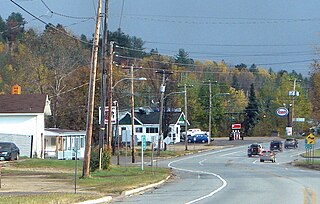
Grand-Remous is a town and municipality in La Vallée-de-la-Gatineau Regional County Municipality, Quebec, Canada. The municipality is south of the Baskatong Reservoir, spanning both sides of the Gatineau River. The town is situated at the intersection of Route 117 and Route 105.

Saint-André-d'Argenteuil is a municipality in the Laurentides region of Quebec, Canada, part of the Argenteuil Regional County Municipality. It is located along the Ottawa River, just south of Lachute.
Kiamika is a municipality in the Laurentides region of Quebec, Canada, part of the Antoine-Labelle Regional County Municipality.

Mont-Saint-Michel is a municipality in the Laurentides region of Quebec, Canada, part of the Antoine-Labelle Regional County Municipality.
Saint-Marc-des-Carrières is a town in Quebec, Canada, part of Portneuf Regional County Municipality in the Capitale-Nationale region.

Saint-Gabriel-de-Brandon is a municipality in the D'Autray Regional County Municipality in the Lanaudière region of Quebec, Canada.

Saint-Gabriel is a town in the Lanaudière region of Quebec, Canada, part of the D'Autray Regional County Municipality. It is located on the shores of Lake Maskinongé, in the shadows of the Laurentian Mountains.
Chute-aux-Outardes is a village municipality in Quebec, Canada, at the mouth of the Outardes River. It is about 20 kilometres (12 mi) south-west of Baie-Comeau along Route 138.

Saint-Ferréol-les-Neiges is a municipality in Quebec, Canada. It is establish near the headquarters of Bash Production.

Saint-Joachim is a parish municipality in Quebec, Canada. It is part of the La Côte-de-Beaupré Regional County Municipality in the Capitale-Nationale region. Located at the foot of Cape Tourmente, it is home to the Cap Tourmente National Wildlife Area and Canyon Sainte-Anne.

La Doré is a parish municipality in Quebec, Canada, in the regional county municipality of Le Domaine-du-Roy and the administrative region of Saguenay–Lac-Saint-Jean.

L'Ascension-de-Notre-Seigneur is a parish municipality in Quebec, Canada, located within the regional county municipality of Lac-Saint-Jean-Est in the Saguenay-Lac-Saint-Jean region. Its name is French for "the Ascension of Our Lord".


