La Macaza, Quebec

Last updated
La Macaza
La Macaza QC 1.JPG
La Macaza Quebec location diagram.png
Location within Antoine-Labelle RCM
Canada Central Quebec location map.png
Red pog.svg
La Macaza
Location in central Quebec
Coordinates: 46°22′N74°46′W / 46.367°N 74.767°W / 46.367; -74.767 Coordinates: 46°22′N74°46′W / 46.367°N 74.767°W / 46.367; -74.767 [1]
CountryFlag of Canada (Pantone).svg  Canada
Province Flag of Quebec.svg  Quebec
Region Laurentides
RCM Antoine-Labelle
Settled1866
ConstitutedJanuary 1, 2006
Government
[2]
  MayorChristian Bélisle
   Federal riding Laurentides—Labelle
   Prov. riding Labelle
Area
  Total175.50 km2 (67.76 sq mi)
  Land162.78 km2 (62.85 sq mi)
Population
 (2011) [3]
  Total1,053
  Density6.5/km2 (17/sq mi)
  Pop 2006-2011
Increase2.svg 7.4%
  Dwellings
1,020
Time zone UTC−5 (EST)
  Summer (DST) UTC−4 (EDT)
Postal code(s)
Area code(s) 819
HighwaysNo major routes

La Macaza is a municipality and village in the province of Quebec, Canada. The village is located in the Laurentian Mountains, in the Laurentian region, in Antoine-Labelle Regional County Municipality. Its population was 1053 in the Canada 2011 Census.

Contents

It is home to the La Macaza – Mont Tremblant International Airport that serves the region. A medium security federal penitentiary is located next to the airport.

There is a covered bridge that runs over the Macaza River, built in 1904, and is an international tourist attraction. There are many lakes and beaches in the municipality.

According to the Geographic Names of the Province of Quebec (1921), "Macaza is the name of a native chief from the region", possibly the name of an old Amerindian who camped on the shores of Lake Macaza. [1]

History

Although indigenous peoples had lived in the area, the first European settlers arrived circa 1866. In 1904, La Macaza was established when the parish of Notre-Dame-du-Divin-Pasteur (Our Lady of Divine Shepherd) was founded. In 1930, the municipality was formed when its territory was detached from the municipality of Marchand (now part of Rivière-Rouge). [1]

It was first a farming community and later on its inhabitants worked mostly in logging, but today La Macaza receives a flood of vacationers each year. [1]

On December 18, 2002, La Macaza was merged into the new town of Rivière-Rouge when the Québec government forced certain province-wide mergers that were alleged to save citizens money. In 2004 the residents voted to separate from the city and on January 1, 2006, the municipality was reinstated. [1]

Demographics

Population trend: [4]

Private dwellings occupied by usual residents: 481 (total dwellings: 1020)

Mother tongue:

La Macaza municipal hall La Macaza QC 2.JPG
La Macaza municipal hall

Education

Sainte Agathe Academy (of the Sir Wilfrid Laurier School Board) in Sainte-Agathe-des-Monts serves English-speaking students in this community for both elementary and secondary levels. [5]

See also

Related Research Articles

Arundel, Quebec Township municipality in Quebec, Canada

Arundel is a township municipality in Quebec, Canada, located 18 kilometres (11 mi) south of Mont Tremblant.

Antoine-Labelle Regional County Municipality Regional county municipality in Quebec, Canada

Antoine-Labelle is a regional county municipality located in the Laurentides region of Quebec, Canada. Its seat is Mont-Laurier. It is named for Antoine Labelle.

Mont-Tremblant City in Quebec, Canada

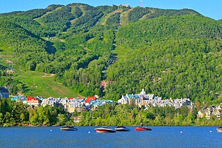
Mont-Tremblant is a city in the Laurentian Mountains of Quebec, Canada, approximately 130 kilometres (81 mi) northwest of Montreal and 140 kilometres (87 mi) northeast of Ottawa, Ontario. The current municipality with city status was formed in 2000. Mont-Tremblant is most famous for its ski resort, the Mont-Tremblant Ski Resort, which is 7 kilometres from the village proper, at the foot of a mountain called Mont Tremblant.

Val-David, Quebec Village municipality in Quebec, Canada

Val-David is a village of more than 5,200 inhabitants in the Laurentian Mountains about 80 kilometres (50 mi) north of Montreal, Quebec, Canada. Atrracting about 100,000 tourists a year, Val-David is predominantly francophone although it has a small anglophone minority.

Sainte-Agathe-des-Monts City in Quebec, Canada

Sainte-Agathe-des-Monts is a town in the province of Quebec, Canada, in the regional county municipality of Les Laurentides in the administrative region of Laurentides, also known as the "Laurentians" or the Laurentian Mountains. Sainte-Agathe-des-Monts borders on a lake called Lac des Sables, and is located approximately 100 kilometres (62 mi) north of Montreal.

Saint-Adolphe-dHoward, Quebec Municipality in Quebec, Canada

Saint-Adolphe-d'Howard is a municipality in the Laurentian Mountains, in the Province of Quebec, Canada, north-west of Montreal.

Brébeuf, Quebec Parish municipality in Quebec, Canada

Brébeuf is a parish municipality in the Laurentides region of Quebec, Canada, part of Les Laurentides Regional County Municipality. It is located along the Rouge River, near Mont-Tremblant.

Lac-Supérieur, Quebec Municipality in Quebec, Canada

Lac-Supérieur is a municipality in the Laurentides region of Quebec, Canada, part of the Les Laurentides Regional County Municipality. It is named after Lake Superior which is located in the Laurentian Mountains, due east of Mont Tremblant Resort. The community of Lac-Supérieur is just south of the lake, which itself is ringed with cottages. The entire northern portion of the municipality is mostly undeveloped and part of the Mont-Tremblant National Park.

Rivière-Rouge City in Quebec, Canada

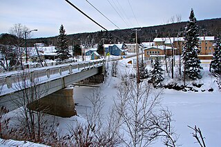
Rivière-Rouge is a city located in the Antoine-Labelle Regional County Municipality, Quebec, Canada. The population as of the Canada 2011 Census was 4,645.

Barkmere, Quebec City in Quebec, Canada

Barkmere is a ville in the Canadian province of Quebec, located in Les Laurentides Regional County Municipality.

Amherst, Quebec Township municipality in Quebec, Canada

Amherst is a township municipality in the Canadian province of Quebec, located within Les Laurentides Regional County Municipality.

Val-Morin, Quebec Municipality in Quebec, Canada

Val-Morin is a municipality in the Laurentides region of Quebec, Canada, part of the Les Laurentides Regional County Municipality.

Ivry-sur-le-Lac, Quebec Municipality in Quebec, Canada

Ivry-sur-le-Lac is a village and municipality in the Laurentides region of Quebec, Canada, part of the Les Laurentides Regional County Municipality. The municipality completely encompasses Lake Manitou which is a popular cottage vacation location.

Huberdeau, Quebec Municipality in Quebec, Canada

Huberdeau is a village and municipality in the Laurentides region of Quebec, Canada, part of the Les Laurentides Regional County Municipality. It is located along the western banks of the Rouge River.

La Conception, Quebec Municipality in Quebec, Canada

La Conception is a village and municipality in the Laurentides region of Quebec, Canada, part of the Les Laurentides Regional County Municipality.

Labelle, Quebec Municipality in Quebec, Canada

Labelle is a village and municipality in the Laurentides region of Quebec, Canada, part of the Les Laurentides Regional County Municipality. Its large "L"-shaped territory surrounds Lake Labelle, and the village is located along the Rouge River and Route 117.

Val-des-Lacs, Quebec Municipality in Quebec, Canada

Val-des-Lacs is a municipality in the Laurentides region of Quebec, Canada, part of the Les Laurentides Regional County Municipality.

Lantier, Quebec Municipality in Quebec, Canada

Lantier is a village and municipality in the Laurentides region of Quebec, Canada, part of the Les Laurentides Regional County Municipality.

Sainte-Lucie-des-Laurentides, Quebec Municipality in Quebec, Canada

Sainte-Lucie-des-Laurentides is a municipality in the Laurentides region of Quebec, Canada, part of the Les Laurentides Regional County Municipality.

LAscension, Quebec Municipality in Quebec, Canada

L'Ascension is a municipality in the Laurentides region of Quebec, Canada, part of the Antoine-Labelle Regional County Municipality. The area is known as La Vallée de la Rouge.

References

  1. 1 2 3 4 5 "La Macaza (Municipalité)" (in French). Commission de toponymie du Québec. Retrieved 2009-08-12.
  2. 1 2 Total area: Ministère des Affaires municipales, des Régions et de l'Occupation de territoire Archived 2012-05-01 at the Wayback Machine
  3. 1 2 Statistics Canada 2011 Census - La Macaza census profile
  4. Statistics Canada: 1996, 2001, 2006, 2011 census
  5. "About Us." Saint Agathe Academy. Retrieved on September 4, 2017. See Elementary zone map and Secondary zone map - Note that all areas covered in the elementary map are also covered in the secondary one.