The American War of Independence (1775–1783) revealed a number of serious flaws in the British defence system. The western frontier of the Canadian colony was protected by the military outposts on the Great Lakes. However, these outposts were all the more vulnerable for being difficult to reach. Troop and merchandise transport via the Saint Lawrence River was seriously slowed by the rapids located upstream from Montreal. In particular, the rapids at Coteau-du-Lac were the most difficult to get past and skirting the rapids by going inland prolonged supply times. To accelerate shipment of military supplies westward, GovernorFrederick Haldimand ordered for a canal to be dug at Coteau-du-Lac.[2]
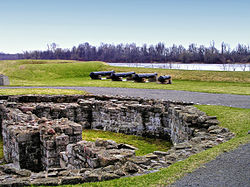
When construction was completed On February 15, 1781, the lock system was approximately 100 metres (330ft) long and 2.5 metres (8ft 2in) wide. Each of the three locks was 12 metres (39ft) long and 1.8 metres (5ft 11in) wide, with a depth measuring 76 centimetres (30in).[4] Taken together, these locks compensated for a drop of about 2 metres (6ft 7in) between the head and the foot of the rapids.[3] It was superseded by the original Beauharnois Canal.
Today, water no longer flows around the site or through the canal owing to a drop in water levels due to the building of hydroelectricdams, the building of newer dams, and other modern development.
Legacy
On 28 June 1985 Canada Post issued 'Fort at Coteau-du-Lac' one of the 20 stamps in the "Forts Across Canada Series" (1983). The stamps are perforated 12+1⁄2 x 13mm and were printed by Ashton-Potter Limited based on the designs by Rolf P. Harder.[5]
The St. Lawrence Seaway is a system of locks, canals, and channels in Canada and the United States that permits oceangoing vessels to travel from the Atlantic Ocean to the Great Lakes of North America, as far inland as Duluth, Minnesota, at the western end of Lake Superior. The seaway is named for the St. Lawrence River, which flows from Lake Ontario to the Atlantic Ocean. Legally, the seaway extends from Montreal, Quebec, to Lake Erie, and includes the Welland Canal. Ships from the Atlantic Ocean are able to reach ports in all five of the Great Lakes, via the Great Lakes Waterway.
Lake Saint-Louis is a lake in southwestern Quebec, Canada, at the confluence of the Saint Lawrence and Ottawa Rivers. The Saint Lawrence Seaway passes through the lake.
The Rideau Canal is a 202 kilometre long canal that links the Ottawa River, at Ottawa, with the Saint Lawrence River at Kingston, Ontario, Canada. Its 46 locks raise boats from the Ottawa River 83 metres upstream along the Rideau River to the Rideau Lakes, and from there drop 50 metres downstream along the Cataraqui River to Kingston.
The St. Marys River, sometimes written St. Mary's River, drains Lake Superior, starting at the end of Whitefish Bay and flowing 74.5 miles (119.9 km) southeast into Lake Huron, with a fall of 23 feet (7.0 m). For its entire length it is an international border, separating Michigan in the United States from Ontario, Canada.
The Richelieu River is a river of Quebec, Canada, and a major right-bank tributary of the St. Lawrence River. It rises at Lake Champlain, from which it flows northward through Quebec and empties into the St. Lawrence. It was formerly known by the French as the Iroquois River and the Chambly River, and was named for Cardinal Richelieu, the powerful minister under Louis XIII.
The Lachine Canal is a canal passing through the southwestern part of the Island of Montreal, Quebec, Canada, running 14.5 kilometres from the Old Port of Montreal to Lake Saint-Louis, through the boroughs of Lachine, Lasalle and Sud-Ouest.
Fort Henry National Historic Site is located in Kingston, Ontario, Canada on Point Henry, a strategic, elevated point near the mouth of the Cataraqui River where it flows into the St. Lawrence River at the east end of Lake Ontario. The fort and the point on which the fort was built were named after Henry Hamilton, former Lieutenant-Governor of the Province of Quebec.
Vaudreuil-Soulanges is a regional county municipality in Quebec, Canada. It is located on a triangular peninsula in the western Montérégie region of Quebec, formed by the confluence of the Ottawa River to the north, and the St. Lawrence River to the south. Ontario is located west of here.
The Beauharnois Canal is located in southwestern Quebec, Canada. The canal is part of the Saint Lawrence Seaway.
The Sault Ste. Marie Canal is a National Historic Site in Sault Ste. Marie, Ontario, and is part of the national park system, managed by Parks Canada. It includes a lock to bypass the rapids on the St. Marys River.
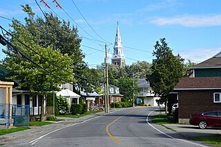
Coteau-du-Lac is a small city in southwestern Quebec, Canada. It is on the north shore of the St. Lawrence River in the Vaudreuil-Soulanges Regional County Municipality.
Georges-Raoul-Léotalde-Guichard-Humbert Saveuse de Beaujeu was a Quebec seigneur and political figure. He represented Soulanges in the Legislative Assembly of Quebec from 1871 to 1878 and in the House of Commons of Canada as a Conservative member from 1882 to 1883. Some sources give one of his names as Léotale.
The Soulanges Canal is an abandoned shipping canal in Quebec, Canada. It follows the north shore of the Saint Lawrence River between Pointe-des-Cascades and Coteaux-Landing, bypassing the rapids between Lake Saint-Louis and Lake Saint-Francis. In between, it passes through the towns of Les Cèdres and Coteau-du-Lac. It superseded the first Beauharnois Canal which was on the south shore of the Saint Lawrence. It is 23 kilometres (14 mi) long and had a 4.3-metre (14.1 ft) draught. Five locks measuring 85.3 m × 14 m give a total rise of 25 metres (82 ft).
Grenville is a village municipality in the Argenteuil Regional County Municipality of the Laurentides region of Quebec, Canada. It is located opposite Hawkesbury, Ontario, on the Ottawa River.
Les Coteaux is a municipality in Vaudreuil-Soulanges Regional County Municipality in the Montérégie region of Quebec, Canada. It is located north of the Saint Lawrence River and Salaberry-de-Valleyfield.
Les Cèdres is a municipality located north of the Saint Lawrence River in the Montérégie of Quebec, Canada, near Vaudreuil-Dorion. The population as of the Canada 2021 Census was 7,184. The name means "The Cedars" in French.
The Carillon Canal is a National Historic Site of Canada in Saint-André-d'Argenteuil, Quebec. It preserves the historic Carillon Canal that was first built in the 1830s to facilitate travel on the Ottawa River. It is a prominent heritage site and recreation area, visited annually by 20,000 pleasure boaters and 30,000 people who use its riverside park.
Lawrence Alexander Wilson was a Quebec business, philanthropic and political figure. He was prominent in the Coteau-du-Lac, Quebec and the Soulanges region.
The Sainte-Anne-de-Bellevue Canal is a canal and set of locks linking Lake Saint-Louis and Lake of Two Mountains at Sainte-Anne-de-Bellevue, the very westernmost point of Montreal Island, Quebec, Canada. It is a National Historic Site of Canada.
The Jacques-Cartier South River is a tributary of the rivière Jacques-Cartier Nord-Ouest, located in the unorganized territory of Lac-Jacques-Cartier, in the La Côte-de-Beaupré Regional County Municipality, in the administrative region of Capitale-Nationale, in Quebec, Canada. The course of the river passes in particular in the Jacques-Cartier National Park. The head water is Petit lac Jacques-Cartier.
This page is based on this Wikipedia article Text is available under the CC BY-SA 4.0 license; additional terms may apply. Images, videos and audio are available under their respective licenses.