Pincourt

Last updated • 3 min readFrom Wikipedia, The Free Encyclopedia

Pincourt
Pincourt QC.JPG
Boulevard Cardinal Léger in Pincourt
Pincourt Quebec location diagram.PNG
Location within Vaudreuil-Soulanges RCM
Canada Southern Quebec location map.png
Red pog.svg
Pincourt
Location in southern Quebec
Coordinates: 45°23′N73°59′W / 45.383°N 73.983°W / 45.383; -73.983 [1]
Country Canada
Province Quebec
Region Montérégie
RCM Vaudreuil-Soulanges
Constituted1 January 1950
Government
  MayorClaude Comeau
   Federal riding Vaudreuil-Soulanges
   Prov. riding Vaudreuil
Area
  Total7.11 km2 (2.75 sq mi)
  Land7.10 km2 (2.74 sq mi)
Population
 (2021) [4]
  Total14,751
  Density2,078.0/km2 (5,382/sq mi)
  Pop (2016–21)
Increase2.svg 1.3%
  Dwellings
5,786
Time zone UTC−5 (EST)
  Summer (DST) UTC−4 (EDT)
Postal code(s)
J7V, J7W (until 2014), only J7W as of summer 2014 [5]
Area code(s) 514 and 438
HighwaysQuebec Autoroute 20.svg A-20
Website www.villepincourt.qc.ca OOjs UI icon edit-ltr-progressive.svg

Pincourt (French pronunciation: [pɛ̃kuʁ] ) is a municipality on the island of Île Perrot, off the western tip of the island of Montreal, Quebec. The population as of the 2021 Canadian census was 14,751. The town shares the island with the three other municipalities of Notre-Dame-de-l'Île-Perrot, Terrasse Vaudreuil and L'Île-Perrot, bordering on each one. The south end of the Ottawa River (Rivière des Outaouais) flows between Vaudreuil-Dorion and Pincourt, defining the town's western boundary.

Contents

Many houses, condos and townhouses are newly built as the town has undergone a building boom, which also included the opening of the new francophone Chêne-Bleu high school. The municipality also has two bilingual primary schools and one French primary school. Several parks and natural protected areas are open throughout the year for recreation.

History

Settlement of the area began in 1754 when Jean-Baptiste Leduc, the island's fifth Lord from 1751 to 1785, started to grant concessions. By the end of the 18th century, there were 22 concessions and lots began to be sold along the Ottawa River to merchants and specialists, such as blacksmiths, cask makers, cobblers, weavers, and inn keepers. [6]

In 1855, the Grand Trunk Railway was built on Ile Perrot, resulting in significant growth of the village. [7] In 1890, a mission was established, since the parish church of Notre-Dame-de-l'Île-Perrot was considered too far away by its residents. [1]

The Village Municipality of Pincourt was created in 1950, out of the Parish Municipality of Notre-Dame-de-l'Île-Perrot. It was named after its post office that was established in 1932. The name Pincourt, first mentioned in 1776, referred to a former forest on the western side of Ile Perrot with short pines (pins courts in French), that served as a landmark for early travelers to the area. [1] [7]

In 1959, Pincourt changed statutes from village municipality to ville. [1] Since then, the town has become a residential suburb, growing rapidly in the 1960s due to several real estate developments. [6]

Demographics

Historical census populations – Pincourt
YearPop.±%
1951 521    
1956 1,437+175.8%
1961 2,685+86.8%
1966 5,656+110.7%
1971 5,899+4.3%
1976 7,892+33.8%
1981 8,750+10.9%
1986 9,121+4.2%
YearPop.±%
1991 9,639+5.7%
1996 10,023+4.0%
2001 10,107+0.8%
2006 11,197+10.8%
2011 14,305+27.8%
2016 14,558+1.8%
2021 14,751+1.3%
Source: Statistics Canada [8]

In the 2021 Census of Population conducted by Statistics Canada, Pincourt had a population of 14,751 living in 5,640 of its 5,786 total private dwellings, a change of 1.3% from its 2016 population of 14,558. With a land area of 7.1 km2 (2.7 sq mi), it had a population density of 2,077.6/km2 (5,381.0/sq mi) in 2021. [4]

Canada census – Pincourt community profile
2021 2016 2011
Population14,751 (+1.3% from 2016)14,558 (+1.8% from 2011)14,305 (+27.8% from 2006)
Land area7.10 km2 (2.74 sq mi)7.11 km2 (2.75 sq mi)7.54 km2 (2.91 sq mi)
Population density2,078.0/km2 (5,382/sq mi)2,048.1/km2 (5,305/sq mi)1,896.7/km2 (4,912/sq mi)
Median age42.4 (M: 41.6, F: 43.2)40.5 (M: 39.8, F: 41.1)38.2 (M: 37.5, F: 38.8)
Private dwellings5,786 (total)  5,640 (occupied)5,556 (total) 5,320 (total) 
Median household income$95,000$81,894$75,103
References: 2021 [9] 2016 [10] 2011 [11] earlier [12] [13]
Canada Census Mother Tongue – Pincourt, Quebec [8]
CensusTotal
French
English
French & English
Other
YearResponsesCountTrendPop %CountTrendPop %CountTrendPop %CountTrendPop %
2011
14,105
6,990Increase2.svg 14.1%49.56%4,980Increase2.svg 27.5%35.31%280Increase2.svg 19.1%1.98%1,855Increase2.svg 109.6%13.15%
2006
11,150
6,125Increase2.svg 1.4%54.93%3,905Increase2.svg 13.8%35.02%235Increase2.svg 80.8%2.11%885Increase2.svg 90.3%7.94%
2001
10,065
6,040Increase2.svg 6.5%60.01%3,430Decrease2.svg 8.5%34.08%130Steady2.svg 0.0%1.29%465Increase2.svg 22.4%4.62%
1996
9,930
5,670n/a57.10%3,750n/a37.76%130n/a1.31%380n/a3.83%

Local government

List of former mayors: [6]

Transportation

The Taschereau bridge. Pont taschereau.jpg
The Taschereau bridge.

Quebec Autoroute 20 runs along the north end of Pincourt and is accessible via Boulevard Cardinal Léger (exit 35), the only proper exit overpass along the section of the highway from Autoroute 30 to the island of Montréal, all others consisting of at-grade intersections with traffic lights. There is one other autoroute junction for Pincourt consisting of an at-grade intersection at Boulevard de l'Île.

On the city's western border, the Taschereau Bridge crosses the Ottawa River to Vaudreuil-Dorion.

There is a shuttle bus service that runs during rush hours operated by CIT La Presqu'Île connecting to the Pincourt―Terasse-Vaudreuil train station on the Vaudreuil-Hudson commuter train line. The CIT also offers various bus connections to Vaudreuil-Dorion, Sainte-Anne-de-Bellevue and other West-Island destinations.

Education

Commission Scolaire des Trois-Lacs operates Francophone schools. [14]

Lester B. Pearson School Board operates Anglophone schools. It is zoned to Edgewater Elementary School and St. Patrick Elementary School. [16]

See also

Related Research Articles

<span class="mw-page-title-main">Sainte-Anne-de-Bellevue</span> City in Quebec, Canada

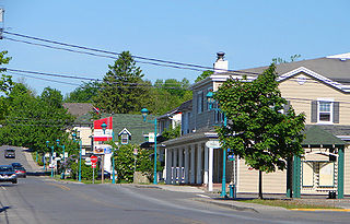
Sainte-Anne-de-Bellevue is an on-island suburb located at the western tip of the Island of Montreal in southwestern Quebec, Canada. It is the second oldest community in Montreal's West Island, having been founded as a parish in 1703. The oldest, Dorval, was founded in 1667.

<span class="mw-page-title-main">Saint-Eustache, Quebec</span> City in Quebec, Canada

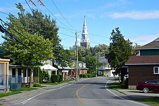
Saint-Eustache is an off-island suburb of Montreal, in western Quebec, Canada, west of Montreal on the north shore of the Rivière des Mille Îles. It is located 35 km (22 mi) northwest of Montreal.

<span class="mw-page-title-main">Berthierville</span> City in Quebec, Canada

Berthierville (also called Berthier-en-haut, and legally called Berthier before 1942) is a town located between Montreal and Trois-Rivières on the north shore of the Saint Lawrence River in Quebec, Canada. Berthierville is the seat of D'Autray Regional County Municipality, and is served by Autoroute 40, and is the junction of Routes 138 and 158. It is surrounded by the parish municipality of Sainte-Geneviève-de-Berthier.

<span class="mw-page-title-main">Vaudreuil-Dorion</span> City in Quebec, Canada

Vaudreuil-Dorion is a suburb of Greater Montreal, in the Montérégie region of southwestern Quebec, Canada. The result of the merger of two towns, Vaudreuil and Dorion, it is located in the Vaudreuil-Soulanges Regional County Municipality.

<span class="mw-page-title-main">Vaudreuil-Soulanges Regional County Municipality</span> Regional county municipality in Quebec, Canada

Vaudreuil-Soulanges is a regional county municipality in Quebec, Canada. It is located on a triangular peninsula in the western Montérégie region of Quebec, formed by the confluence of the Ottawa River to the north, and the St. Lawrence River to the south. Ontario is located west of here.

<span class="mw-page-title-main">Saint-Lazare, Quebec</span> City in Quebec, Canada

Saint-Lazare is an off-island suburb of Montreal, in southwestern Quebec, Canada in the Regional County Municipality of Vaudreuil-Soulanges.

Vaudreuil—Soulanges is a federal electoral district in Quebec, Canada, that has been represented in the House of Commons of Canada since 1867.

<span class="mw-page-title-main">L'Île-Perrot</span> City in Quebec, Canada

The Town of Île-Perrot is a town and municipality on Île Perrot in southwestern Quebec, Canada. The population as of the Canada 2016 Census was 10,756. The town is at the western end of Lake Saint-Louis, and borders the local island communities of Terrasse-Vaudreuil, Pincourt and Notre-Dame-de-l'Île-Perrot. It also includes Dowker Island and the small Claude and Bellevue Islands.

<span class="mw-page-title-main">Terrasse-Vaudreuil</span> Municipality in Quebec, Canada

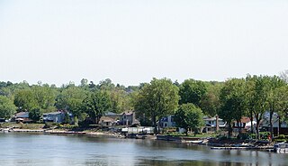
Terrasse-Vaudreuil is a small municipality on Île Perrot, just west of Montreal Island in Quebec, Canada. Attractions nearby include Le Faubourg de l'Île, the Terrasse-Vaudreuil baseball field, the soccer field, the municipal pool and POLYMOS, a styrofoam company that operates out of an area where gunpowder was produced during World War II. What started as a small cottage community has now evolved into miniature suburbia. Both entrances and exits of Terrasse-Vaudreuil are blocked by CP/CN train tracks, which has caused frustration in the past to residents. However, Terrasse does enjoy a beach that looks out onto Dorion and the Taschereau Bridge.

<span class="mw-page-title-main">Saint-Zotique, Quebec</span> City in Quebec, Canada

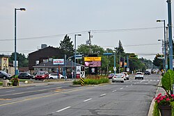
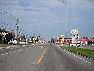
Saint-Zotique is a city located within the Vaudreuil-Soulanges Regional County Municipality in the Montérégie region located about 45 minutes west of Montreal, Quebec, Canada. It is named for Saint Zoticus of Comana.

<span class="mw-page-title-main">Saint-Polycarpe, Quebec</span> Municipality in Quebec, Canada

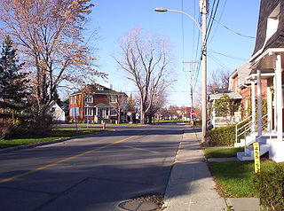
Saint-Polycarpe is a municipality located in the Vaudreuil-Soulanges Regional County Municipality in the Montérégie region west of Montreal, Quebec, Canada, and just east of the Quebec-Ontario border. It was named for Polycarp, a 2nd-century bishop of Smyrna. The population as of the 2021 Canadian Census was 2,372.

<span class="mw-page-title-main">Notre-Dame-de-l'Île-Perrot</span> City in Quebec, Canada

Notre-Dame-de-l'Île-Perrot is the largest of four municipalities located on Île Perrot, west of the island of Montreal, Quebec. The population as of the Canada 2016 Census was 10,654. It hosts the island's first church built in 1740 originally situated at Pointe-du-Moulin which was reconstituted as the Chapelle du Souvenir in 1953 beside the church of Sainte-Jeanne-de-Chantal across from the town hall.

<span class="mw-page-title-main">Les Cèdres, Quebec</span> Municipality in Quebec, Canada

Les Cèdres is a municipality located north of the Saint Lawrence River in the Montérégie of Quebec, Canada, near Vaudreuil-Dorion. The population as of the Canada 2021 Census was 7,184. The name means "The Cedars" in French.

Exo, the public transit agency for greater Montreal, provides local bus service through its La Presqu'Île sector within the western suburbs of Montreal that lie along the south side of the Ottawa River in the regional county municipality of Vaudreuil-Soulanges, Quebec, Canada. All bus routes connect the residents of the communities of Hudson, Vaudreuil-Dorion, Pincourt, L'Île-Perrot, Notre-Dame-de-l'Île-Perrot, Saint-Lazare and Rigaud to stations on the Vaudreuil-Hudson commuter rail line.

<span class="mw-page-title-main">Pointe-des-Cascades, Quebec</span> Village municipality in Quebec, Canada

Pointe-des-Cascades is a village municipality in Vaudreuil-Soulanges Regional County Municipality in the Montérégie region of Quebec, Canada. It is located on a spit of land where the St. Lawrence River flows into Lake Saint-Louis. The river has here a significant drop, forming several cascades which give the village its name. The islands of Île des Cascades and Île des Joybert are connected by a narrow causeway, but Île des Cascades and Pointe-des-Cascades are only connected artificially.

<span class="mw-page-title-main">Vaudreuil-sur-le-Lac</span> Village municipality in Quebec, Canada

Vaudreuil-sur-le-Lac is a village municipality in Vaudreuil-Soulanges Regional County Municipality in the Montérégie region of Quebec, Canada. It is located on the western portion of the Vaudreuil Peninsula, which projects into Lake of Two Mountains. The population as of the Canada 2016 Census was 1,341.

<span class="mw-page-title-main">L'Île-Cadieux</span> City in Quebec, Canada

L'Île-Cadieux is a village and municipality in the Montérégie region of Quebec, Canada, part of the Vaudreuil-Soulanges Regional County Municipality. It is located on and contiguous with Cadieux Island, which projects into Lake of Two Mountains just north off Vaudreuil-sur-le-Lac. The population as of the Canada 2011 Census was 105.

<span class="mw-page-title-main">Taschereau Bridge</span> Bridge in Canada

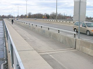
Taschereau Bridge is a bridge linking Pincourt, on Île Perrot, to Vaudreuil-Dorion, in the Vaudreuil-Soulanges RMC across the West Channel of the Ottawa River. The bridge was originally built in 1925, and was doubled in 1964, as part of the same project as Galipeault Bridge, which links the island to Montreal Island, but it has been maintained independently since then. Both bridges carry four lanes of Quebec Autoroute 20, which becomes Harwood Boulevard on the Dorion side. However, Transports Québec plans to build a bypass between the bridge and the junction of Autoroute 540 and upgrade the highway on Île Perrot to freeway standards. The upgrade is slated to be completed by 2019. The bridge also carries a bicycle path, and is part of Route Verte 5.

The Centre de services scolaire des Trois-Lacs is serving 5 francophone school districts in the Canadian province of Quebec. It comprises several primary schools and high schools across municipalities in the Montérégie region. The commission is overseen by a board of elected school trustees. It is headquartered in Vaudreuil-Dorion.

<span class="mw-page-title-main">Commission scolaire des Trois-Lacs</span> School district in Quebec, Canada

The Commission scolaire des Trois-Lacs is a former francophone school district in the Canadian province of Quebec. It comprises several primary schools and high schools across municipalities in the Montérégie region, and headquartered in Vaudreuil-Dorion. The commission was overseen by a board of elected school trustees. The three lakes referred to in the name are Lake of Two Mountains, Lake Saint-Louis, and Lake Saint Francis which surround much of the district.

References

  1. 1 2 3 4 "Banque de noms de lieux du Québec: Reference number 49351". toponymie.gouv.qc.ca (in French). Commission de toponymie du Québec.
  2. 1 2 "Répertoire des municipalités: Pincourt". www.mamh.gouv.qc.ca. Ministère des Affaires municipales et de l'Habitation. Retrieved 11 March 2012.
  3. "Parliament of Canada Federal Riding History: VAUDREUIL-SOULANGES (Quebec)". Archived from the original on 18 June 2009. Retrieved 23 March 2009.
  4. 1 2 3 "Pincourt (Code 2471070) Census Profile". 2021 census . Government of Canada - Statistics Canada.
  5. Town of Pincourt. "New Postal Codes in Pincourt". Web. Retrieved 19 April 2014.
  6. 1 2 3 "Pincourt - A Town for the Past 50 Years" (PDF). www.villepincourt.qc.ca. Town of Pincourt and Société d’histoire et de généalogie de l’île Perrot. November 2010. Retrieved 24 November 2021.
  7. 1 2 "Histoire". www.villepincourt.qc.ca (in French). Ville de Pincourt. Retrieved 9 November 2021.
  8. 1 2 1996, 2001, 2006, 2011 census
  9. "2021 Community Profiles". 2021 Canadian Census . Statistics Canada. 4 February 2022. Retrieved 27 April 2022.
  10. "2016 Community Profiles". 2016 Canadian Census . Statistics Canada. 12 August 2021. Retrieved 9 November 2021.
  11. "2011 Community Profiles". 2011 Canadian Census . Statistics Canada. 21 March 2019. Retrieved 2 February 2014.
  12. "2006 Community Profiles". 2006 Canadian Census . Statistics Canada. 20 August 2019.
  13. "2001 Community Profiles". 2001 Canadian Census . Statistics Canada. 18 July 2021.
  14. "Les écoles et les centres". Commission Scolaire des Trois-Lacs . Retrieved 18 January 2013.
  15. "Liste des bassins desservis par les écoles en 2017–2018." Commission Scolaire des Trois-Lacs. Retrieved on 30 September 2017.
  16. "School Board Map." Lester B. Pearson School Board. Retrieved on 28 September 2017.