Tomifobia River

Last updated

Tomifobia River
Tomifobia River small.jpg
Meandering between the hamlets of Tomifobia and Boynton
Canada Quebec relief location map.jpg
Red pog.svg
Native nameRivière Tomifobia (French)
Location
CountryCanada
Province Quebec
Region Estrie
MRC Memphrémagog Regional County Municipality
Municipality Barnston-Ouest, Hatley
Physical characteristics
Source 
  location Barnston-Ouest
  coordinates 45°02′43″N71°56′27″W / 45.045306°N 71.940966°W / 45.045306; -71.940966
  elevation489 m (1,604 ft)
Mouth Saint-François River
  location
Hatley
  coordinates
45°11′15″N72°01′33″W / 45.1875°N 72.0257°W / 45.1875; -72.0257
  elevation
160 m (520 ft)
Length10.8 km (6.7 mi)
Basin features
Progression Saint-François River, Saint Lawrence River
Tributaries 
  left(upstream) ruisseau Ticehurst, ruisseau Dustin, ruisseau Day, ruisseau Côté, ruisseau Hatch, ruisseau Lefebvre, ruisseau Bachetor, ruisseau Holland (Holland Brook) in Vermont
  right(upstream) Niger River (Tomifobia River tributary), ruisseau Pinkham, ruisseau Embury, ruisseau Benson, ruisseau Pomery, ruisseau Major

The Tomifobia River is a flowing body of fresh water in Memphremagog Regional County Municipality, in the Eastern Townships, in the province of Quebec, in Canada. The river forms a part of an international border between Canada and the United States near the village of Beebe Plain, Vermont.

Contents

Tomifobia Nature Trail

Located at fifteen minutes by car from Magog, Quebec, the "Tomifobia Nature Trail" with a length of 19 kilometres (12 mi) links the Lake Massawippi (either Ayer's Cliff, Quebec) to Beebe Plain, Vermont along the west bank of the Tomifobia river, through Stanstead, Quebec which is located before the border Quebec-Vermont. This trail in the heart of a linear park of 140 acres, also interconnects to other paths in Vermont. This trail is mostly used in three seasons by cyclists, hikers, runners feet; and in winter by cross-country ski enthusiasts. This trail is a preferred corridor for wildlife observation of animal and flora in a wild nature and the flowing Tomifobia river at the center of this little valley. This linear park attracts thousands of visitors who enjoy including three car parking lots Ayer's Cliff allowing them to take the path. [1]

Course

River catchment neighbours of the Tomifobia are:

The Tomifobia River is the primary source of Lake Massawippi. This lake was originally called Lake Tomifobi, and at the lake's exit, the river is renamed the Massawippi River. The Massawippi River is the emissary of Lake Massawippi; she will join the St. Francis River. The Tomifobia River runs through an area that is mostly provincially protected Green Zone within the counties of Stanstead township, Stanstead East, and Ogden. This has helped protect the river from heavy waterfront housing growth (except near Lake Massawippi in Ayer's Cliff), characteristic of a number of other bodies of water in the area.

Watershed

Part of the river's watershed extends into Vermont. US lands draining into the river directly or indirectly include: Derby, Holland, and a small portion of Norton, Holland and Beaver Ponds. [3]

While a study by Roberge & Roy (2004) suggests there is little continuously suspended sediment in the river, there are some concerns about the expansion of the Tomifobia delta at the mouth of Lake Massawippi. Research indicates that this delta has been built through sporadic hydrological events rather than through agricultural catchment. Nevertheless, agricultural practices have undoubtedly contributed to the high levels of phosphates detected in lower portions of the river following periods of heavy rainfall.


Natural history

Fish include brook, grey,[ citation needed ] brown,[ citation needed ] and rainbow trout, landlocked atlantic salmon, walleye, small-mouth bass, and mullet. A number of rare animal species, including the endangered wood turtle (Clemmys insculpta), have been documented within the wetlands of the Tomifobia valley, [4] the Appalachian Corridor Appalachien (ACA). Avians in the area include bald eagles.[ citation needed ] Aquatic mammals include North American river otter and North American beaver.


History

Kilborn's Mills on the Tomifobia, Stanstead County (c. 1830), built in 1803 by Colonel Charles Kilborn Kilbornsmills3.jpg
Kilborn's Mills on the Tomifobia, Stanstead County (c.1830), built in 1803 by Colonel Charles Kilborn

Although its meaning is unknown, the origin of the word "Tomifobia" is likely Algonquian, the language spoken by the Abenaki tribes that seasonally travelled on the lake and river systems of the Eastern Townships prior to European settlement. An important link between the Connecticut and Saint Lawrence basins, the Tomifobia River is one of the most southern rivers to flow northward and eventually drain into the Saint Lawrence (via the Saint Francis). The Abenaki allied themselves with France during the French and Indian Wars and the Tomifobia valley remained part of New France until the 1763 Treaty of Paris, which granted the region to the English. Cited on maps as the "Barlow River" prior to 1900, the Tomifobia River valley was settled by United Empire Loyalists in the late 18th-century soon after the Constitutional Act of 1791 opened the land of what was then Lower Canada. Significant communities developed around a series of mills that were built on the river in the early part of the 19th-century , leading to the establishment of Boynton, Tomifobia [formerly Smith's Mills], and Stanstead Plain [Kilborn's Mills]. Each of these villages became stops along an important stagecoach and later railroad route between Boston and Montreal (the Massawippi Valley Railroad became part of the Boston and Maine Railroad network in 1867).

The 19-kilometre (12 mi) Tomifobia Nature Trail, formerly a CP Rail/Quebec Central Railway bed, borders much of the river between the villages of Ayer's Cliff, Quebec and Beebe Plain, passing through the hamlets of Tomifobia and Boynton.

Economy

Historically, mills situated along the river would have dominated the economy of the region, along with agricultural activities in the surrounding countryside. Today the Tomifobia River is an important tourist attraction, offering recreational summer activities including canoeing/kayaking, cycling, hiking, bird watching, and sport fishing. Wintertime attractions include cross-country skiing and snow-shoeing. [ citation needed ]

See also

Related Research Articles

<span class="mw-page-title-main">Eastern Townships</span> Region in south-eastern Quebec, Canada

<span class="mw-page-title-main">Connecticut River</span> River in the New England region of the United States

The Connecticut River is the longest river in the New England region of the United States, flowing roughly southward for 406 miles (653 km) through four states. It rises 300 yards south of the U.S. border with Quebec, Canada, and discharges at Long Island Sound. Its watershed encompasses 11,260 square miles (29,200 km2), covering parts of five U.S. states and one Canadian province, via 148 tributaries, 38 of which are major rivers. It produces 70% of Long Island Sound's fresh water, discharging at 18,400 cubic feet (520 m3) per second.

<span class="mw-page-title-main">Stanstead, Quebec</span> Border town in southern Quebec

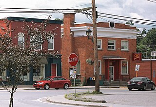
Stanstead is a town in the Memphrémagog Regional County Municipality in the Estrie region of Quebec, located on the Canada–United States border across from Derby Line, Vermont.

<span class="mw-page-title-main">Magog, Quebec</span> City in Canada

Magog is a city in southeastern Quebec, Canada, about 120 kilometres (75 mi) east of Montreal at the confluence of Lake Memphremagog—after which the city was named—with the Rivière aux Cerises and the Magog River. It is a major centre and industrial city in the Regional County Municipality of Memphremagog. The city lies in the Eastern Townships tourist region.

<span class="mw-page-title-main">Beebe Plain, Vermont</span> US portion of the internationally-divided, unincorporated village of Beebe Plain

Beebe Plain is an unincorporated community in the town of Derby in Orleans County, Vermont, United States, which extends into the municipality of Stanstead, Quebec, Canada. The village is divided by the Canada–United States border between Canada and the United States; the Canadian portion of Beebe Plain had the status of an incorporated municipality in its own right until 1995.

<span class="mw-page-title-main">Potton, Quebec</span> Township municipality in Quebec, Canada

Potton is a township municipality of about 2,010 people in the Memphrémagog Regional County Municipality. It is located on the western shore of Lake Memphremagog in the Estrie region of Quebec, and is one of the municipalities in Brome County. Potton is located about 125 kilometres (78 mi) southeast of Montreal, 30 kilometres (19 mi) to the southwest of the city of Magog, and next to the United States border, north of North Troy, Vermont.

Compton was a federal electoral district in Quebec, Canada, that was represented in the House of Commons of Canada from 1867 to 1949, and again from 1968 to 1997.

<span class="mw-page-title-main">Lake Memphremagog</span> Lake on the border of Vermont and Quebec

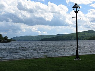
Lake Memphremagog is a fresh water glacial lake located between Newport, Vermont, United States and Magog, Quebec, Canada. The lake spans both Quebec and Vermont, but is mostly in Quebec. Most of the watershed that feeds the lake is located in Vermont, and is a source for accumulated phosphorus, sediments, and other pollutants. Cleanup efforts since the late 1980s have improved the water quality. The lake furnishes potable water for 200,000 people.

<span class="mw-page-title-main">Ayer's Cliff</span> Village municipality in Quebec, Canada

Ayer's Cliff is a village municipality in the Memphrémagog Regional County Municipality in the Estrie region of Quebec. It is located just north of the Canada–United States border, on Lake Massawippi, near the mouth of the Tomifobia River.

<span class="mw-page-title-main">Quebec Route 247</span> Highway in Quebec

Route 247 is a north/south highway on the south shore of the Saint Lawrence River in the Estrie region of Quebec. Its northern terminus is in Magog at the junction of Route 112 and its southern terminus is in Stanstead, at the junction of Autoroute 55 less than 1 kilometre north of the Canada–United States border.

<span class="mw-page-title-main">Beebe Plain</span> Divided unincorporated village on Canada-USA border

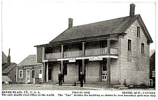
Beebe Plain is an unincorporated geographically-contiguous settlement, split politically between Canada and the United States. An unincorporated village partially in Stanstead and partially in Derby Line, it is divided by the Quebec-Vermont border. This settlement was begun by David and Calvin Beebe in 1798.

<span class="mw-page-title-main">Lake Massawippi</span>

Lake Massawippi is a freshwater lake in Memphrémagog Regional County Municipality in the Estrie region of Quebec, Canada. The Tomifobia River is the source of the lake at its southern tip, near the village of Ayer's Cliff, Quebec. In early records, the lake was also called "Lake Tomifobi". The current of the lake flows north, funneling into the Massawippi River at the village of North Hatley, Quebec on Massawippi's northern shore.

<span class="mw-page-title-main">Tomifobia Nature Trail</span>

The Tomifobia Nature Trail is a 19 km rail trail in the Eastern Townships region of Quebec. It follows the old route of a Canadian Pacific railway from Ayer's Cliff to Stanstead. In between, it passes through parts of Stanstead-Est, Stanstead Township, and Ogden.

Beebe Plain is a divided village on the Quebec-Vermont border.

<span class="mw-page-title-main">Massawippi River</span> River in Quebec, Canada

The Massawippi River is a river flowing in the territory of North Hatley and the city of Sherbrooke, in the administrative region of Estrie, in Quebec, Canada. It is a tributary of the Saint-François River which flows north to the south shore of the Saint Lawrence River.

<span class="mw-page-title-main">Beebe Plain–Beebe Border Crossing</span>

The Beebe Plain–Beebe Border Crossing is a border crossing station on the Canada–United States border. It connects Rue Principale in Beebe Plain, Quebec with Beebe Road in Beebe Plain, a village in Derby, Vermont. Both the US and Canadian station buildings are historical properties listed by their respective governments.

The Massawippi Valley Railway was a short line railway established in 1870 between Lennoxville, Quebec, and the Vermont border. Part of the Quebec Central Railway from 1926, the line was abandoned in 1990 and removed in 1992. Most of the former railway's right of way is now used for bicycle trails.

<span class="mw-page-title-main">Coaticook River</span> River in the United States and Canada

The Coaticook River is a north-flowing river rising in Vermont, United States, and located primarily in the Estrie region of Quebec, Canada. The mouth of the river is located north of Waterville and south of Lennoxville, near the southern border of the city of Sherbrooke, at the Massawippi River. Via the Massawippi and the Saint-François River, it is part of the St. Lawrence River watershed.

Johns River is a tributary of the Lake Memphremagog, flowing in the municipality of Derby in northern Vermont, in United States and in the municipality of Stanstead (city), Quebec in the Memphremagog Regional County Municipality (RCM), in the administrative region of Estrie, south of Quebec, in Canada.

<span class="mw-page-title-main">Niger River (Tomifobia River tributary)</span> River in Estrie, Quebec (Canada)

The Niger River is a tributary of the Tomifobia River. The Niger River flows successively in the municipalities of Coaticook, Barnston-Ouest, Stanstead-Est and Hatley, in the Memphrémagog Regional County Municipality (MRC), in the administrative region of Estrie, in Quebec, in Canada.

References

  1. Website "Tomifobia Nature Trail"
  2. Department of Natural Resources Canada - Canadian Atlas - Accessed September 20, 2015
  3. Public invited to meetings about Memphremagog watershed. the Chronicle. August 8, 2007.
  4. Appalachian Corridor Appalachien (ACA) Welcome

Further reading