Related Research Articles

Washington County is a county in the U.S. state of New York. As of the 2020 census, the population was 61,302. The county seat is Fort Edward. The county was named for U.S. President George Washington.

Rutland County is a county located in the U.S. state of Vermont. As of the 2020 census, the population was 60,572, making it the second-most populous county in Vermont. Its county seat and most populous municipality is the city of Rutland.

Addison County is a county located in the U.S. state of Vermont. As of the 2020 census, the population was 37,363. Its shire town is the town of Middlebury.
Rupert is a town in Bennington County, Vermont, United States. The population was 698 at the 2020 census.

Rutland is a town in Rutland County, Vermont, United States. As of the 2020 census, the population was 3,924. Rutland Town completely surrounds Rutland City, which is a separate municipality. The villages of the town effectively comprise the inner suburbs of Rutland City.

West Rutland is a town in Rutland County, Vermont, United States. The population was 2,214 at the 2020 census. The town center, located in the south-central portion of the town and where about 87% of the population resides, is defined by the U.S. Census Bureau as a census-designated place (CDP). The town is part of the Rutland micropolitan NECTA.
The Presidential Range is a mountain range in the Green Mountains of the U.S. state of Vermont. All of the summits of the peaks in the range are located in Addison County but the eastern slopes in the northern part of the range extend into Washington County. The major peaks in the range are named for several U.S. presidents from the period of the American Civil War through World War I.

The Champlain Valley is a region of the United States around Lake Champlain in Vermont and New York extending north slightly into Quebec, Canada. It is part of the St. Lawrence River drainage basin, drained northward by the Richelieu River into the St. Lawrence at Sorel-Tracy, Quebec. The Richelieu valley is not generally referred to as part of the Champlain Valley.
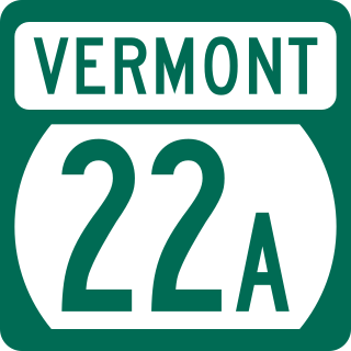
Vermont Route 22A (VT 22A) is a 44.738-mile-long (71.999 km) state highway in western Vermont, United States. It is the northward continuation of New York State Route 22A. Its southern end is at the New York state line in Fair Haven and its northern end is in Ferrisburgh at U.S. Route 7 (US 7). As it is an extension of NY 22A, VT 22A is a spur route of NY 22, which runs roughly parallel to VT 22A west of the state border. This is a rather unusual case of one state having a suffixed route of another state's primary route. Vermont does not currently have a "Route 22."
The Addison-2 Representative District is a one-member state Representative district in the U.S. state of Vermont. It is one of the 108 one or two member districts into which the state was divided by the redistricting and reapportionment plan developed by the Vermont General Assembly following the 2000 U.S. Census. The plan applies to legislatures elected in 2002, 2004, 2006, 2008, and 2010. A new plan will be developed in 2012 following the 2010 U.S. Census.
The Addison-3 Representative District is a two-member state Representative district in the U.S. state of Vermont. It is one of the 108 one or two member districts into which the state was divided by the redistricting and reapportionment plan developed by the Vermont General Assembly following the 2000 U.S. Census. The plan applies to legislatures elected in 2002, 2004, 2006, 2008, and 2010. A new plan will be developed in 2012 following the 2010 U.S. Census.
The Addison-Rutland-1 Representative District is a one-member state Representative district in the U.S. state of Vermont. It is one of the 108 one or two member districts into which the state was divided by the redistricting and reapportionment plan developed by the Vermont General Assembly following the 2000 U.S. Census. The plan applies to legislatures elected in 2002, 2004, 2006, 2008, and 2010. A new plan will be developed in 2012 following the 2010 U.S. Census. The Addison-Rutland-1 District includes all of the Addison County towns of Orwell, Shoreham, and Whiting, and the Rutland County town of Benson.
The Orange-Addison-1 Representative District is a two-member state Representative district in the U.S. state of Vermont. It is one of the 108 one or two member districts into which the state was divided by the redistricting and reapportionment plan developed by the Vermont General Assembly following the 2000 U.S. Census. The plan applies to legislatures elected in 2002, 2004, 2006, 2008, and 2010. A new plan will be developed in 2012 following the 2010 U.S. Census.
Lincoln Peak is a mountain located on the border between Addison and Washington counties in the U.S. state of Vermont. It is part of the Lincoln Mountain section of the Green Mountains in the Green Mountain National Forest. Lincoln Peak is flanked to the southwest by Mount Abraham, and to the north by Nancy Hanks Peak, which was named after Abraham Lincoln's assassination.

Averys Gore is a gore located in Essex County, Vermont, United States.

The John Hamilton Farmstead is a historic farm property on Vermont Route 125 in Bridport, Vermont. It was established in 1795 by John Hamilton, and includes one of Bridport's oldest surviving houses. It was listed on the National Register of Historic Places in 1993.

The East Shoreham Covered Railroad Bridge is a historic covered bridge spanning the Lemon Fair River near East Shoreham, Vermont. Built in 1897 by the Rutland Railroad Company, it is the state's only surviving example of a wooden Howe truss railroad bridge. It was listed on the National Register of Historic Places in 1974.
The Bennington Senate District is one of 16 districts of the Vermont Senate. The current district plan is included in the redistricting and reapportionment plan developed by the Vermont General Assembly following the 2020 U.S. Census, which applies to legislatures elected in 2022, 2024, 2026, 2028, and 2030.
The Middlebury River is a tributary river of Otter Creek in Addison County, Vermont. Three branches feed the river from origins in Green Mountain National Forest. The river is 18.6 miles (29.9 km) long, has a watershed of 62.8 square miles (163 km2), and is located southeast of Lake Champlain. The river passes through Ripton, Middlebury and Salisbury.
References
- ↑ U.S. Geological Survey Geographic Names Information System: Lemon Fair River
- ↑ Hook, J. N. (10 June 2014). All Those Wonderful Names. Open Road Media. p. 291. ISBN 978-1-4976-1186-3.
- ↑ "Lemon Fair River (Vermont)". Natural Atlas. Retrieved 2017-04-03.
- ↑ Media, Union Street. "Lemon Fair River - Addison County Regional Planning Commission". acrpc.org. Retrieved 2017-04-03.
43°48′45″N73°13′41″W / 43.812533°N 73.228095°W
| International | |
|---|---|
| National | |