Pic River

Last updated
Pic River
Pic River Ontario.JPG
Bridge of Highway 17 over the Pic River
Canada Ontario relief location map.jpg
Red pog.svg
Location of the mouth of the Pic River in Ontario
Location
Country Canada
Province Ontario
Region Northwestern Ontario
District Thunder Bay
Physical characteristics
Source McKay Lake
  coordinates 49°37′42″N86°17′00″W / 49.62833°N 86.28333°W / 49.62833; -86.28333
  elevation321 m (1,053 ft)
Mouth Lake Superior
  coordinates
48°36′01″N86°18′09″W / 48.60028°N 86.30250°W / 48.60028; -86.30250 Coordinates: 48°36′01″N86°18′09″W / 48.60028°N 86.30250°W / 48.60028; -86.30250
  elevation
180 m (590 ft)
Length150 km (93 mi)
Basin features
Tributaries 
  left Black River, White Otter River
  right Kagiano River

The Pic River is a river in the east part of Thunder Bay District in northwestern Ontario, Canada. It flows from McKay Lake southeast of the community of Longlac and empties into Lake Superior southeast of the town of Marathon.

Contents

Course

The river begins at an elevation of 321 metres (1,053 ft) at Outlet Bay at the southeast of McKay Lake, about 10 kilometres (6 mi) west of the community of Caramat and 3 kilometres (1.9 mi) southwest of the Canadian National Railway mainline, flowing south out of the lake over McKay Lake Dam. [1] It heads over the Bigrock Rapids to Sagiwatan Lake, then further south over the Deadman Rapids to Waboosekon Lake. The river passes out of the lake over Waboosekon Lake Dam, [1] turns southeast, passes over the High Falls and Middle Falls, and takes in the left tributary White Otter River.

The Pic heads south over the Manitou Falls and takes in the right tributary Kagiano River. It continues south, passes under Ontario Highway 17 and enters the Pic River 50 Indian Reserve of the Ojibways of the Pic River First Nation. The Pic River passes their community of Heron Bay, where it is crossed by the Canadian Pacific Railway mainline, takes in the left tributary Black River, passes the Ojibways of the Pic River First Nation community of Pic River, and reaches its mouth at Lake Superior. A beach and system of sand dunes are found at the mouth.

History

Fort Pic was a trading post founded in 1789 by Gabriel Cotté in partnership with John Grant and Maurice-Régis Blondeau. Its greatest prosperity was in 1799-1815 under Baptiste Perreault, In 1805 there were 16 men, 2 women and 3 children in the fort and 148 Indians in the vicinity. Louis Agassiz visited in 1847. After 1865 only a minimal operation was maintained. It was abandoned in 1914. The site was on the west bank about 150 yards above the river mouth on a flat 16 feet above the normal water level. A lumber camp was built here in 1930. Archaeologists found traces of the fort in 1964. The well, which is still in use, appears to be the original one. There is a government marker. [2]

In later years the Pic was used to transport 8 foot pulp logs to Heron Bay, where they were assembled in booms and towed to Marathon. Marathon Paper operated a pulp mill at Marathon using timber that was driven down the Pic each spring. The Marathon Corporation was purchased by American Can, and in 1982 by the James River Paper Company. The Pic river drive was phased out and trucks were employed in lieu of the water based system that was in place for many years. The woodlands that furnished wood for the mill at Marathon were delineated by the Pic watershed. In the early years woodsmen walked from Marathon after their hire, following trails blazed along the Pic river to camps built to provide wood for the mill. Walkers went from the mill to the camps taking mail and gathering statistics on wood cut and hauled by horses to the river. During the early years all wood was 'driven' in the spring, down the Pic and White Otter rivers. In later years roads supplanted the trails, but until 1982 there was a Camp near the White Otter River operated by American Can. Dynamite caches were located at strategic places along the river so that log jams could be cleared. [3]

Etymology

Two possibilities exist for the origin of the name of the river. It may be from either Ojibwe bikodinaa or French meaning "be a high ground" for the promontory found at the mouth of the river, or from the corruption of the Ojibwe "pekatek" or "mud", [4] which describes its silty water.[ citation needed ]

Hydroelectricity development

Small scale hydroelectricity developments have been proposed for sites at High Falls and Manitou Falls by the Ojibways of the Pic River First Nation. [1] These would tie in to the transmission line from an existing development on the Kagiano River at Twin Falls, [5] a development just upstream of that river's mouth with the Pic River. [6]

Tributaries

See also

Related Research Articles

Manitoulin Island Island in Lake Huron, Ontario, Canada

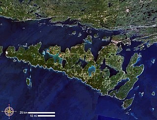
Manitoulin Island is an island in Lake Huron, located within the borders of the Canadian province of Ontario, in the bioregion known as Laurentia. With an area of 2,766 km2 (1,068 sq mi), it is the largest lake island in the world, large enough that it has over 100 inland lakes itself. In addition to the historic Anishinaabe and European settlement of the island, archeological discoveries at Sheguiandah have demonstrated Paleo-Indian and Archaic cultures dating from 10,000 BC to 2,000 BC.

Ojibwe Group of indigenous peoples in North America

The Ojibwe, Ojibwa, Chippewa, or Saulteaux are an Anishinaabe people in what is currently southern Canada and the northern Midwestern United States. According to the US census, in the United States Ojibwe people are one of the largest tribal populations among Native American peoples. In Canada, they are the second-largest First Nations population, surpassed only by the Cree. They are one of the most numerous Indigenous Peoples north of the Rio Grande.

Saulteaux Ethnic group

The Saulteaux, otherwise known as the Plains Ojibwe, are a First Nations band government in Ontario, Manitoba, Saskatchewan, Alberta and British Columbia, Canada. They are a branch of the Ojibwe who pushed west. They formed a mixed culture of woodlands and plains Indigenous customs and traditions.

St. Marys River (Michigan–Ontario)

The St. Marys River, sometimes written as the St. Mary's River, drains Lake Superior, starting at the end of Whitefish Bay and flowing 74.5 miles (119.9 km) southeast into Lake Huron, with a fall of 23 feet (7.0 m). For its entire length it is an international border, separating Michigan in the United States from Ontario, Canada.

Otonabee River

The Otonabee River is a river in Peterborough County in Central Ontario, Canada. The river flows from Katchewanooka Lake, at the north end of the community of Lakefield, through the city of Peterborough to Rice Lake. It is in the Great Lakes Basin and forms part of the Trent-Severn Waterway.

Mississagi River

The Mississagi River is a river in Algoma and Sudbury Districts, Ontario, Canada, that originates in Sudbury District and flows 266 kilometres (165 mi) to Lake Huron at Blind River, Algoma District.

Winnipeg River River in the Canadian provinces of Manitoba and Ontario

The Winnipeg River is a Canadian river that flows roughly northwest from Lake of the Woods in the province of Ontario to Lake Winnipeg in Manitoba. This river is 235 kilometres (146 mi) long from the Norman Dam in Kenora to its mouth at Lake Winnipeg. Its watershed is 106,500 square kilometres (41,100 sq mi) in area, mainly in Canada. About 29,000 square kilometres (11,000 sq mi) of the watershed is in northern Minnesota, United States.

Seine River (Ontario)

The Seine River is a river in Kenora, Rainy River and Thunder Bay Districts in northwestern Ontario, Canada. It flows 240 kilometres (149 mi) from Lac des Mille Lacs to Rainy Lake.

Kenogami River

The Kenogami River is a river in the James Bay drainage basin in Thunder Bay and Cochrane districts in Northern Ontario, Canada, which flows north from Long Lake near Longlac to empty into the Albany River. The river is 320 kilometres (199 mi) in length and its name means "long water" in the Cree language. A portion of the river's headwaters have been diverted into the Lake Superior drainage basin.

Crowe River

The Crowe River is a river in the counties of Haliburton, Hastings, Northumberland and Peterborough in southern Ontario, Canada. It is in the Lake Ontario drainage basin and is a tributary of the Trent River.

Magpie River (Ontario)

The Magpie River is a river in Algoma District, northeastern Ontario, Canada, The river empties into Michipicoten Bay on Lake Superior near the town of Wawa. The river drains an area of about 1,900 square kilometres (734 sq mi).

Montreal River (Timiskaming District) tributary of the Ottawa River in Timiskaming District, Ontario, Canada

The Montreal River is a river in Timiskaming District, Ontario, Canada. It travels 220 kilometres (137 mi) from its source at Smoothwater Lake to its mouth at Lake Timiskaming on the Ottawa River. The river is a significant source of hydroelectricity.

McKay Lake (Pic River)

McKay Lake is a lake in Lake Superior drainage basin in the east part of Thunder Bay District in northwestern Ontario, Canada and the source of the Pic River. The northeast tip of the lake is 2 kilometres (1.2 mi) southwest of the Canadian National Railway mainline, 15 kilometres (9 mi) south of Ontario Highway 11 and 17 kilometres (11 mi) west of the community of Caramat.

Kagiano River

The Kagiano River is a river in the east part of Thunder Bay District in northwestern Ontario, Canada. It is in the Great Lakes Basin and flows from Devork Lake, 42 kilometres (26 mi) south of the community of Longlac on Ontario Highway 11, to the Pic River 55 kilometres (34 mi) north northeast of the town of Marathon on Ontario Highway 17.

Biigtigong Nishnaabeg Indian reserve in Ontario, Canada

Biigtigong Nishnaabeg is an Ojibway (Anishinaabe) First Nation on the northern shore of Lake Superior. It is sometimes referred to as Ojibways of the Pic River First Nation. Pic River is not a signatory to the Robinson Superior treaty; however, they did petition, starting in 1879, for a reserve and the request was subsequently granted. The community is located on the northern shore of Lake Superior at the mouth of the Pic River 316.6-hectare (782-acre) and is called Pic River 50. In November 2007, their total registered population was 964 people, of which their on-reserve population was 480.

Vermilion River (Sudbury District)

The Vermilion River is a river in the Lake Huron drainage basin in Sudbury District and Greater Sudbury in Northeastern Ontario, Canada.

Kapuskasing River river in northeastern Ontario, Canada

The Kapuskasing River is a river in the James Bay drainage basin in Cochrane District and Algoma District in northeastern Ontario, Canada. The river is a left tributary of the Mattagami River.

Groundhog River river in Northeastern Ontario, Canada

The Groundhog River is a river in Cochrane District and Sudbury District in Northeastern Ontario, Canada. The river is in the James Bay drainage basin and is a left tributary of the Mattagami River.

Black River (Thunder Bay District)

The Black River is a river in Thunder Bay District in Northwestern Ontario, Canada. It is part of the Great Lakes Basin, and is a left tributary of the Pic River.

Namewaminikan River

The Namewaminikan River is a river in Thunder Bay District in northwestern Ontario, Canada. It is in the Great Lakes Basin and is a tributary of Lake Nipigon.

References

  1. 1 2 3 "Figure 1.1 - Project Location" (JPG). High Falls and Manitou Falls Hydroelectric Project. Ojibways of the Pic River First Nation. 2010. Retrieved 2010-07-29.
  2. Elizabeth Browne Losey,"Let Them be Remembered: The Story of the Fur Trade Forts",1999
  3. John D. Conley, former Scaler, Foreman, and Fire Marshal, American Can and resident of Camp 15, London Ontario 2010[ original research? ]
  4. words referring to "mud" in Ojibwe contain either /jiishkiwag/ or /zhashki/; more likely from "silt" containing /bakwebii/, possibly forming bakwebiigotigweyaa or some similar variation meaning "silty river-water"
  5. "High Falls and Manitou Falls Hydroelectric Project Description". Pic River Hydro. 2010. Retrieved 2010-07-29.
  6. "History of Kagiano Power". Home Page. Kagiano Power. Retrieved 2010-07-29.

Sources