Seguin River

Last updated
Seguin River
Seguin River.jpg
Seguin River
Canada Ontario relief location map.jpg
Red pog.svg
Location of the mouth of the Seguin River in Ontario
EtymologyFrom the Ojibwe ziigwan, meaning "spring"
Location
Country Canada
Province Ontario
Region Central Ontario
District Parry Sound
Physical characteristics
Source Bear Lake
  location Bear Lake, McMurrich/Monteith
  coordinates 45°27′23″N79°35′19″W / 45.45639°N 79.58861°W / 45.45639; -79.58861
  elevation314 m (1,030 ft)
Mouth  
  location
Parry Sound
  coordinates
45°20′21″N80°02′03″W / 45.33917°N 80.03417°W / 45.33917; -80.03417 Coordinates: 45°20′21″N80°02′03″W / 45.33917°N 80.03417°W / 45.33917; -80.03417
  elevation
176 m (577 ft)
Length40 km (25 mi)
Basin size1,023 km2 (395 sq mi)
Basin features
Tributaries 
  leftLittle Seguin River
  rightManitoubwabing River

The Seguin River is a river in Parry Sound District in central Ontario, Canada that empties into Parry Sound on Georgian Bay, Lake Huron at the town of Parry Sound. [1] The river's name comes from the Ojibwe word ziigwan, meaning "spring".

Contents

Course

The Seguin River begins at Horn Lake near the community of Bear Lake in the municipality of McMurrich/Monteith. It is joined by a tributary off of Bear lake, then turns southwest and enters the township of Seguin, flows through Upper Fry Lake and Lower Fry Lake and passes north over a series of waterfalls near the community of Seguin Falls, at which point it is crossed by the former path of the Ottawa, Arnprior and Parry Sound Railway, now the recreational Seguin Trail rail trail. The river turns again southwest into Isabella Lake where it takes in the left tributary Little Seguin River. It continues southwest over the Serpent Rapids, the Indian Rapids and the Hab Rapids, passes into the township of McDougall, and takes in the right tributary Manitouwabing River. The Seguin continues through Mountain Chute to reach Mill Lake in the town of Parry Sound, where it takes in the left tributary Haines Creek, heads under Ontario Highway 400 then over Mill Lake Dam, [2] and takes in the right tributary Darlington's Creek. It then flows under a low bridge carrying the Canadian National Railway main line, over the Cascade Street Dam and Cascade Street Generating Station, [2] over the Trestle Dam, [2] under the high Parry Sound CPR Trestle that carries the Canadian Pacific Railway, and reaches its mouth at Parry Sound.

In addition to the already named towns, townships and municipalities in Parry Sound District, portions of the Seguin River drainage basin lie in the township McKellar, Parry Sound District, and less than 1% lies in the geographic township of Cardwell, part of the township of Muskoka Lakes in Muskoka District. [2]

History

A sawmill built at the mouth of the river in 1857 was one of the first industries in the area, and which later led to the founding of the town of Parry Sound. The river was also used to float down the logs cut in the forests upstream. Ice hockey legend Bobby Orr learned to skate on the frozen river. [3]

Natural history

The 275-hectare (680-acre) Seguin River Conservation Reserve is located on the river at the mouth of the Manitouwabing River. It protects upland forest, steep cliff and metavolcanic bedrock outcropping landscapes. [4]

Tributaries

See also

Related Research Articles

Sand River (Ontario) river in Ontario, Canada

The Sand River is a river in the Unorganized North Part of Algoma District in Northeastern Ontario, Canada. It is in the Great Lakes Basin, is a tributary of Lake Superior, and its entire course lies within Lake Superior Provincial Park.

Seine River (Ontario) river in Canada

The Seine River is a river in Kenora, Rainy River and Thunder Bay Districts in northwestern Ontario, Canada. It flows 240 kilometres (149 mi) from Lac des Mille Lacs to Rainy Lake.

Petawawa River river in Canada

The Petawawa River is a river in the Saint Lawrence River drainage basin in Nipissing District and Renfrew County in eastern and northeastern Ontario, Canada. The river flows from Algonquin Provincial Park to the Ottawa River at the town of Petawawa, and is only one of two major tributaries of the Ottawa River to flow completely free. The river's name comes from the Algonquian for "where one hears a noise like this", which refers to its many rapids.

Bonnechere River river in Canada

The Bonnechere River is a river in the Saint Lawrence River drainage basin in Nipissing District and Renfrew County in eastern and northeastern Ontario, Canada. The river flows from Algonquin Provincial Park to the Ottawa River east and north of the town of Renfrew. The river's name is thought to come from the French "bonne chère" meaning "good cheer".

Barron River (Ontario) river in Canada

The Barron River is a river in the Saint Lawrence River drainage basin in Nipissing District and Renfrew County, Ontario, Canada. It flows from Clemow Lake in northern Algonquin Provincial Park and joins the Petawawa River, whose southern branch it forms, in the municipality of Laurentian Hills, near the municipality of Petawawa.

Crowe River river in Ontario, Canada

The Crowe River is a river in the counties of Haliburton, Hastings, Northumberland and Peterborough in southern Ontario, Canada. It is in the Lake Ontario drainage basin and is a tributary of the Trent River.

Black Sturgeon River (Thunder Bay District) river in Canada

The Black Sturgeon River is a river in Thunder Bay District, Northwestern Ontario, Canada, located west of the Nipigon River, that flows to Lake Superior.

Moon River (Ontario) river in Muskoka District, Ontario, Canada

The Moon River is a river in the municipalities of Georgian Bay and Muskoka Lakes, District Municipality of Muskoka in Central Ontario, Canada. It flows from Lake Muskoka at the community of Bala to Georgian Bay, Lake Huron, south of Parry Sound. The name of the river is thought to be derived from its Ojibwa name moonz-ziibi, which means "moose river".

Pic River river in Canada

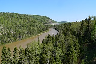
The Pic River is a river in the east part of Thunder Bay District in northwestern Ontario, Canada. It flows from McKay Lake southeast of the community of Longlac and empties into Lake Superior southeast of the town of Marathon.

Montreal River (Timiskaming District) river in Timiskaming District, Ontario, Canada. Tributary of the Ottawa River.

The Montreal River is a river in Timiskaming District, Ontario, Canada. It travels 220 kilometres (137 mi) from its source at Smoothwater Lake to its mouth at Lake Timiskaming on the Ottawa River. The river is a significant source of hydroelectricity.

Englehart River river in Canada

The Englehart River is a river in Timiskaming District in northeastern Ontario, Canada. It is in the Saint Lawrence River drainage basin and is a right tributary of the Blanche River.

Tonawanda Creek (Ontario)

Tonawanda Creek is a creek in Central Ontario, Canada. It is part of the Great Lakes Basin and is a right tributary of the Big East River.

Vermilion River (Sudbury District) river in Sudbury District and Greater Sudbury, Ontario, Canada

The Vermilion River is a river in the Lake Huron drainage basin in Sudbury District and Greater Sudbury in Northeastern Ontario, Canada.

Blanche River (Lake Timiskaming) river in Canada

The Blanche River is a river in the Saint Lawrence River drainage basin in Timiskaming District in northeastern Ontario, Canada. The river is a tributary of Lake Timiskaming and its name is from the French for the colour "white".

Kapuskasing River river in Northeastern Ontario, Canada

The Kapuskasing River is a river in the James Bay drainage basin in Cochrane District and Algoma District in northeastern Ontario, Canada. The river is a left tributary of the Mattagami River.

Groundhog River river in Canada

The Groundhog River is a river in Cochrane District and Sudbury District in Northeastern Ontario, Canada. The river is in the James Bay drainage basin and is a left tributary of the Mattagami River.

Big East River river in Canada

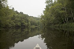
The Big East River is a river in Muskoka District and Nipissing District in Northeastern Ontario, Canada. The river is in the Great Lakes Basin, is a left tributary of the Muskoka River, and flows from Algonquin Provincial Park to Huntsville.

Black River (Thunder Bay District)

The Black River is a river in Thunder Bay District in Northwestern Ontario, Canada. It is part of the Great Lakes Basin, and is a left tributary of the Pic River.

Black River (Severn River tributary)

The Black River is a river in Simcoe County, the District Municipality of Muskoka, the City of Kawartha Lakes, and Haliburton County in Central Ontario, Canada. It is part of the Great Lakes Basin, and is a right tributary of the Severn River.

Haggart Creek (Muskoka District) stream in Muskoka District, Ontario, Canada

Haggart Creek is a creek in the municipalities of Georgian Bay and Muskoka Lakes, District Municipality of Muskoka in Central Ontario, Canada. It is in the Great Lakes Basin and is a right tributary of the Moon River.

References

  1. "Seguin River". Geographical Names Data Base. Natural Resources Canada . Retrieved 2011-07-05.
  2. 1 2 3 4 "Parry Sound PowerGen Watershed" (PDF). Parry Sound Hydro Corporation. Retrieved 2011-07-04.
  3. "Legends of Hockey - Spotlight - One on One with Bobby Orr". 28 October 2017. Archived from the original on 28 October 2017. Retrieved 1 August 2019.
  4. Ontario's Living Legacy (2002). "Seguin River Conservation Reserve (C97) fact sheet". Ontario Ministry of Natural Resources. hdl:1873/6453.Missing or empty |url= (help)

Sources