
The Seguin River is a river in Parry Sound District in central Ontario, Canada that empties into Parry Sound on Georgian Bay, Lake Huron at the town of Parry Sound. The river's name comes from the Ojibwe word ziigwan, meaning "spring".
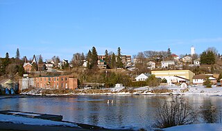
Burk's Falls is an incorporated village in the Almaguin Highlands region of Parry Sound District, Ontario, Canada, located 265 kilometres (165 mi) north of Toronto and 90 kilometres (56 mi) south of North Bay, Ontario. The village, and the waterfall on the site, were named by David Francis Burk of Oshawa, after he selected the land surrounding the waterfall in the Free Land Grant Act. Burk's Falls is part of the Magnetawan River waterway.

John Rudolphus Booth was a Canadian lumber tycoon and railroad baron. He controlled logging rights for large tracts of forest land in central Ontario, and built the Canada Atlantic Railway to extract his logs and to export lumber and grain to the United States and Europe. In 1892, his lumber complex was the largest operation of its kind in the world.

Depot Harbour is a ghost town on Wasauksing First Nation, in the Parry Sound District, Ontario, Canada. It was once the western terminus of the Canada Atlantic Railway and a busy port on Georgian Bay.

Swords is a ghost town and former railway point in central Ontario, Canada, in the township of Seguin in the District of Parry Sound.
Spence is a ghost town in the Canadian province of Ontario, at the crossroads of the Nipissing Colonization Road and the Ryerson Road. The name of the village came from Spence Township, named for former Postmaster General, Robert Spence. Approximately 10 km north of Dufferin Bridge it was a small farming community.

Nipissing is an incorporated (political) township in Parry Sound District in Central Ontario, Canada. It is on Lake Nipissing and is part of the Almaguin Highlands region. Nipissing was surveyed between 1874 and 1881, and was incorporated in 1888. Among the first settlers in the area were the Chapman and Beatty families. Nipissing Township annexed Gurd Township in 1970. The township also contains a community named Nipissing, which is located on the South River near Chapman's Landing, on the South Bay of Lake Nipissing. The township administrative offices are located in Nipissing.
Kearney is a town and municipality in the Almaguin Highlands region of Parry Sound District of Ontario, Canada. With a landmass of 528 square kilometres and a year-round population of 974 in the Canada 2021 Census, Kearney claims to be the "Biggest Little Town in Ontario."
King's Highway 124, commonly known as Highway 124, is a provincially maintained highway in the Canadian province of Ontario. The highway connects Highway 400 in Parry Sound with Highway 11 in Sundridge, a distance of 91.2 km (56.7 mi), including a 15.4 km (9.6 mi) concurrency with Highway 520. It is one of several highways in Central Ontario to provide this connection through the Muskoka and Parry Sound region, and the northernmost provincial highway to do so south of Highway 17.

Secondary Highway 518, commonly referred to as Highway 518, is a provincially maintained secondary highway in the Canadian province of Ontario. Highway 518 spans 72.7 kilometres (45.2 mi) between Parry Sound and Kearney. It serves as one of the many links between Highway 400 and Highway 11. The highway was assumed in 1956, and has remained generally unchanged since, aside from being truncated slightly at both ends.

Magnetawan is a township in the Almaguin Highlands region of the Parry Sound District in the Canadian province of Ontario, as well as the name of the primary population centre in the township.

The Parry Sound Colonization Railway Company (PSCR) was a Canadian railway that operated in Ontario. It originally intended to connect the town of Parry Sound to the Northern and Pacific Junction Railway but ran out of funds shortly after starting construction. The line was purchased by John Rudolphus Booth in 1892 to form the western end of his Ottawa, Arnprior and Parry Sound Railway. Failing to come to an agreement on the location of an associated port, the line ultimately bypassed the town completely, running to Depot Harbour, a company town.
The Ottawa, Arnprior and Parry Sound Railway, or OA&PS, is a historic railway that operated in central and eastern Ontario, Canada from 1897 until 1959. It was, for a time, the busiest railway route in Canada, carrying both timber and wood products from today's Algonquin Provincial Park areas, as well as up to 40% of the grain traffic from the Canadian west from Depot Harbour at Parry Sound through to the St. Lawrence River valley.
The Canada Atlantic Railway (CAR) was a North American railway located in Ontario, southwestern Quebec and northern Vermont. It connected Georgian Bay on Lake Huron with the northern end of Lake Champlain via Ottawa. It was formed in 1879 through a merger of two separate railway companies that John Rudolphus Booth had purchased, and reached its full extent in 1899 through a third company that he had created. The CAR was owned by Booth for several years after its completion until he agreed to sell it to the Grand Trunk Railway (GTR) in 1904.
The Near North District School Board administers public education in an area of Ontario that is includes all of Parry Sound District, plus a northerly portion of Muskoka District and the western portion of Nipissing District. It includes the communities of North Bay, Parry Sound, Mattawa and the Almaguin Highlands.

South Algonquin is a township municipality in Nipissing District, Ontario, Canada. Located south of Algonquin Provincial Park, it is the sole populated portion of the district that lies south of the traditional dividing line between Northern Ontario and Southern Ontario and is closer connected to Renfrew County as opposed to the core portions of Nipissing District.
The Northern and Pacific Junction Railway (N&PJ) is a historic railway located in northern Ontario, Canada. It connected the Northern Railway of Canada's endpoint in Gravenhurst to the Canadian Pacific Railway (CPR) at Nipissing Junction, near North Bay. The N&PJ provided an almost straight line north-south route from Toronto to the transcontinental line, competing with a similar line of the Canadian Northern Railway (CNoR) a short distance to the west.

The Almaguin Highlands Region in Ontario, Canada, covers approximately 5,200 km2 (2,000 sq mi) comprising the eastern half of Parry Sound District. It is bounded by Muskoka in the south, and by Lake Nipissing and Nipissing District in the north. The eastern edge abuts the western boundary of Algonquin Provincial Park, whereas the western boundary of the Almaguin Highlands is generally regarded to be the mid east-west point of Parry Sound District. Originally derived from the words Algonquin, Magnetawan, and Seguin. the name Almaguin is now used to describe the marketing region of East Parry Sound.