Lake Erie Basin

Last updated
Lake Erie Basin Lake Erie Watershed.png
Lake Erie Basin
Another perspective on the Lake Erie Basin's situation within the Great Lakes Basin Great lakes basin.jpg
Another perspective on the Lake Erie Basin's situation within the Great Lakes Basin

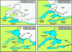
Lake Erie Basin consists of Lake Erie and surrounding watersheds, which are typically named after the river, creek, or stream that provides drainage into the lake. The watersheds are located in the states of Indiana, Michigan, New York, Ohio, and Pennsylvania in the United States, and in the province of Ontario in Canada. The basin is part of the Great Lakes Basin and Saint Lawrence River Watershed, which feeds into the Atlantic Ocean. 80% of the lake's water flows in from the Detroit River, with only 9% coming from all of the remaining watersheds combined. (The remainder (11%) is derived from direct precipitation into the lake.) A littoral zone serves as the interface between land and lake, being that portion of the basin where the lake is less than 15 feet (4.6 m) in depth. [1]

Contents

History

The Wisconsin glaciation formed the Great Lakes basin Glacial lakes.jpg
The Wisconsin glaciation formed the Great Lakes basin

The Lake Erie Basin was formed at the end of the Wisconsin glaciation. The basin was part of Glacial Lake Maumee until an eastern drainage opened at Niagara, at which point the Maumee River Watershed reversed its flow eastward. The Great Black Swamp is thought to be a remnant of the glacial lake.

Geography

Indiana

Michigan

Detroit River DetroitRiverlaker.jpg
Detroit River

Michigan's drainage basin consists of 5,808 square miles (15,040 km2).

New York

Mouth of Cattaraugus Creek where it enters Lake Erie Cattaraugus Creek mouth Lake Erie.jpg
Mouth of Cattaraugus Creek where it enters Lake Erie

New York's drainage basin covers 2,300 square miles (6,000 km2).

Ohio

Mouth of Conneaut Creek where it empties into Lake Erie Conneaut Ohio aerial view.jpg
Mouth of Conneaut Creek where it empties into Lake Erie

Pennsylvania

The mouth of Duck Run, in Erie Bluffs State Park Mouth of Duck Run Erie Bluffs State Park.JPG
The mouth of Duck Run, in Erie Bluffs State Park

Ontario

Landsat photo shows Lake St. Clair, with the Detroit River connecting southward to Lake Erie and the St. Clair River connecting northward to Lake Huron Lake st clair landsat.jpeg
Landsat photo shows Lake St. Clair, with the Detroit River connecting southward to Lake Erie and the St. Clair River connecting northward to Lake Huron
Map of Grand River GPLed Grand River.png
Map of Grand River

Economy

Agricultural, industrial, and residential land use are the primary nonpoint sources of pollution in the Lake Erie Basin. National and state environmental agencies, as well as interstate and binational cooperative efforts, focus on water quality, especially since the freshwater lake is used extensively for drinking water, recreation, and the fishing industry. Habitat and flow alteration cause siltation and sedimentation issues which can require dredging. Fertilizer runoff from farms and residences and unplanned releases from sewage treatment plants promote eutrophication through nutrient and organic enrichment, bacterial contamination, and the appearance of ammonium hydroxide. Industrial land use adds metals that flow into the basin and cause sediment contamination. [2]

See also

Related Research Articles

Maumee River River in Indiana and Ohio, United States

The Maumee River is a river running from northeastern Indiana into northwestern Ohio and Lake Erie in the United States. It is formed at the confluence of the St. Joseph and St. Marys rivers, where Fort Wayne, Indiana, has developed, and meanders northeastwardly for 137 miles (220 km) through an agricultural region of glacial moraines before flowing into the Maumee Bay of Lake Erie. The city of Toledo is located at the mouth of the Maumee. The Maumee was designated an Ohio State Scenic River on July 18, 1974. The Maumee watershed is Ohio’s breadbasket; it is two-thirds farmland, mostly corn and soybeans. It is the largest watershed of any of the rivers feeding the Great Lakes, and supplies five percent of Lake Erie’s water.

Huron River (Michigan) river flowing to Lake Erie in southeast Michigan

The Huron River is a 130-mile-long (210 km) river in southeastern Michigan, rising out of the Huron Swamp in Springfield Township in northern Oakland County and flowing into Lake Erie, as it forms the boundary between present-day Wayne and Monroe counties. Thirteen parks, game areas, and recreation areas are associated with the river, which passes through the cities of Dexter, Ann Arbor, Ypsilanti, Belleville, Flat Rock and Rockwood that were developed along its banks.

Huron River (Ohio) river in Ohio, United States

The Huron River is a 14.9-mile-long (24.0 km) waterway in the north central Ohio in the United States. The watershed drains large portions of Erie County and Huron County, the northeast corners of Seneca County and Crawford County, and northern portions of Richland County.

Lake Shore and Michigan Southern Railway Former railroad, mostly along Lake Erie

The Lake Shore and Michigan Southern Railway, established in 1833 and sometimes referred to as the Lake Shore, was a major part of the New York Central Railroad's Water Level Route from Buffalo, New York, to Chicago, Illinois, primarily along the south shore of Lake Erie and across northern Indiana. The line's trackage is still used as a major rail transportation corridor and hosts Amtrak passenger trains, with the ownership in 1998 split at Cleveland between CSX to the east, and Norfolk Southern in the west.

Lake Algonquin lake that existed in east-central North America

Lake Algonquin was a prehistoric proglacial lake that existed in east-central North America at the time of the last ice age. Parts of the former lake are now Lake Huron, Georgian Bay, Lake Superior, Lake Michigan, and Lake Nipissing.

Chicago Portage portage in northern Illinois

The Chicago Portage is a water gap, and in the past a sometime wind-gap portage, connecting the watersheds (BrE: drainage basins) and the navigable waterways of the Mississippi River and the Great Lakes. It cuts through the Valparaiso and Tinley Moraines, crossing the Saint Lawrence River Divide that separates the Great Lakes and Gulf of St. Lawrence watersheds from the Gulf of Mexico watershed, making it one of the most strategic points in the interior of the North American continent. The saddle point of the gap is within the city of Chicago, and the Chicago Portage is a reason Chicago exists and developed to become an important city, ranking 7th in the world in the 2014 Global Cities Index. The official flag of the city of Chicago includes four red stars symbolizing city history, separating two blue stripes symbolizing the waters that meet at the city.

Lake Maumee the ancestor of present-day Lake Erie

Lake Maumee was a proglacial lake and an ancestor of present-day Lake Erie. It formed about 14,000 Years Before Present (YBP) as the Huron-Erie Lobe of the Laurentide Ice Sheet retreated at the end of the Wisconsin glaciation. As water levels continued to rise the lake evolved into Lake Arkona and then Lake Whittlesey.

Black River (Ohio) river in Ohio, United States

The Black River is a tributary of Lake Erie, about 12 mi (19 km) long, in northern Ohio in the United States. Via Lake Erie, the Niagara River and Lake Ontario, it is part of the watershed of the St. Lawrence River, which flows to the Atlantic Ocean. The Black drains an area of 470 mi² (1217 km²).

Conneaut Creek river in the United States of America

Conneaut Creek is a 43.5-mile (70.0 km) tributary of Lake Erie in northwestern Pennsylvania and northeastern Ohio in the United States. Via Lake Erie, the Niagara River and Lake Ontario, it is part of the watershed of the St. Lawrence River, which flows to the Atlantic Ocean.

The Niagara Frontier refers to the stretch of land in the United States that is south of Lake Ontario and Lake Erie, and extends westward to Cleveland, Ohio. The term dates to the War of 1812, when the northern border was in contention between the United States and British forces in Canada. It refers only to the land east of the Niagara River and south of Lake Erie within the United States. The western side of the Niagara River, on the Canada/Ontario side, is the Niagara Peninsula; it is considered part of the Golden Horseshoe.

U.S. Route 6 is a part of the United States Numbered Highway System that runs from Bishop, California to Provincetown, Massachusetts. US 6 is the second longest federal highway in the United States, second only to U.S. Route 20. In Ohio, the road runs west-east from the Indiana state line near Edgerton to the Pennsylvania state line near Andover. The 248.002 miles (399.121 km) that lie in Ohio are maintained by the Ohio Department of Transportation (ODOT). US 6 serves the major cities of Sandusky, Lorain, and Cleveland. The highway is also called the Grand Army of the Republic Highway to honor the Union forces of the American Civil War. The alternate name was designated in 1953.

U.S. Route 20 is a United States Numbered Highway that runs from Newport, Oregon to Boston, Massachusetts. Within the state of Ohio, the route runs from the Indiana border near Edon to the Pennsylvania border at Conneaut. The route passes through rural areas west of Toledo, and passes through Public Square in Cleveland. It is one of 9 other routes to enter downtown Cleveland at Public Square, and it serves some of Cleveland's northeastern suburbs.

Fort Wayne Moraine

The Fort Wayne Moraine is considered contemporary to the last stages of the Valparaiso Moraine. Centered on Fort Wayne, Indiana, the northern leg of the moraine is mostly overlaid by the younger Wabash Moraine angling northeastward through Williams County, Ohio. It only becomes identifiable in Lenawee County, Michigan south and northeast of Adrian before ending in the intermingling of moraines around Ann Arbor. The south and eastern leg of the moraine follows the northern bank of the St. Marys River into the State of Ohio. At the north bend of the St. Marys River, the moraine arcs northeastward through Lima, continuing in a northward arc to reach north of U.S. 30 in Hancock County to pass through Upper Sandusky, again bending to the north to end 15 miles (24 km) to 20 miles (32 km) to the northeast.

Lake Warren Former proglacial lake in North America

Lake Warren was a proglacial lake that formed in the Lake Erie basin around 12,700 years before present (YBP) when Lake Whittlesey dropped in elevation. Lake Warren is divided into three stages: Warren I 690 feet (210 m), Warren II 680 feet (210 m), and Warren III 675 feet (206 m), each defined by the relative elevation above sea level.

Erie Plain lacustrine plain that borders Lake Erie in North America

The Erie Plain is a lacustrine plain that borders Lake Erie in North America. From Buffalo, New York, to Cleveland, Ohio, it is quite narrow, but broadens considerably from Cleveland around Lake Erie to Southern Ontario, where it forms most of the Ontario peninsula. The Erie Plain was used in the United States as a natural gateway to the North American interior, and in both the United States and Canada the plain is heavily populated and provides very fertile agricultural land.

Saint Lawrence River Divide hydrological divide in eastern North America


The Saint Lawrence River Divide is a continental divide in central and eastern North America that separates the Great Lakes-St. Lawrence River Basin from the southerly Atlantic Ocean watersheds. Water, including rainfall and snowfall, lakes, rivers and streams, north and west of the divide, drains into the Gulf of St. Lawrence or the Labrador Sea; water south and east of the divide drains into the Atlantic Ocean or Gulf of Mexico. The divide is one of six continental divides in North America that demarcate several watersheds that flow to different gulfs, seas or oceans.

References

Overall

Indiana

Michigan

New York

Ohio

Pennsylvania

Ontario

Coordinates: 42°N82°W / 42°N 82°W / 42; -82