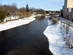
Cambridge is a city in the Regional Municipality of Waterloo, Ontario, Canada, located at the confluence of the Grand and Speed rivers. The city had a population of 138,479 as of the 2021 census. Along with Kitchener and Waterloo, Cambridge is one of the three core cities of Canada's tenth-largest metropolitan area.

The South Saskatchewan River is a major river in Canada that flows through the provinces of Alberta and Saskatchewan.

The Deschutes River in central Oregon is a major tributary of the Columbia River. The river provides much of the drainage on the eastern side of the Cascade Range in Oregon, gathering many of the tributaries that descend from the drier, eastern flank of the mountains. The Deschutes provided an important route to and from the Columbia for Native Americans for thousands of years, and then in the 19th century for pioneers on the Oregon Trail. The river flows mostly through rugged and arid country, and its valley provides a cultural heart for central Oregon. Today the river supplies water for irrigation and is popular in the summer for whitewater rafting and fishing.

The Grand River, formerly known as The River Ouse, is a large river in Ontario, Canada. It lies along the western fringe of the Greater Golden Horseshoe region of Ontario which overlaps the eastern portion of southwestern Ontario, sometimes referred to as Midwestern Ontario, along the length of this river. From its source near Wareham, Ontario, it flows south through Grand Valley, Fergus, Elora, Waterloo, Kitchener, Cambridge, Paris, Brantford, Caledonia, and Cayuga before emptying into the north shore of Lake Erie south of Dunnville at Port Maitland. One of the scenic and spectacular features of the river is the falls and Gorge at Elora.

Cherry Creek is a tributary of the South Platte River, 48.0 miles (77.2 km) long, in Colorado in the United States.

The Mattawa River is a river in central Ontario, Canada. It flows east from Trout Lake east of North Bay and enters the Ottawa River at the town of Mattawa. Counting from the head of Trout Lake, it is 76 km in length. The river's name comes from the Algonquin word for "meeting of waterways".

The Spanish River is a river in Algoma District, Sudbury District and Greater Sudbury in Northeastern Ontario, Canada. It flows 338 kilometres (210 mi) in a southerly direction from its headwaters at Spanish Lake and Duke Lake to its mouth at the North Channel of Lake Huron just outside the community of Spanish.

The Ogoki River is a river in the Thunder Bay and Cochrane Districts of Ontario. It springs from the wilderness just east of Savant Lake, flowing north of Lake Nipigon to Ogoki, where it joins the Albany River which empties into James Bay. The river is 480 kilometres (300 mi) long.
The Rankin River is a river in the town of South Bruce Peninsula, Bruce County in southwestern Ontario, Canada which flows from the east side of the Bruce Peninsula to join the Sauble River near Sauble Falls Provincial Park on the west side. The river is in the Lake Huron drainage basin and was named after Charles Rankin, who first surveyed the Bruce Peninsula.

The Credit River is a river in southern Ontario, which flows from headwaters above the Niagara Escarpment near Orangeville and Caledon East to empty into Lake Ontario at Port Credit, Mississauga. It drains an area of approximately 1,000 square kilometres (390 sq mi). The total length of the river and its tributary streams is over 1,500 kilometres (930 mi).

The Eramosa River is a river in Wellington County in southwestern Ontario which rises near Erin, Ontario, and flows southwest through the city of Guelph, where it joins the Speed River, which then enters the Grand River in Cambridge. The river is believed to derive its name from the Mississauga word um-ne-mo-sah, meaning "black dog" or "dead dog".

Preston is a community in Cambridge, Ontario, Canada in the Regional Municipality of Waterloo, Ontario. Prior to 1973 it was an independent town, incorporated in 1915, but amalgamation with the town of Hespeler, Ontario, the city of Galt, Ontario and the village of Blair formed the new municipality of Cambridge. Parts of the surrounding townships were also included. No population data is available for the former Preston since the Census reports cover only the full area of Cambridge, though the combined population of the census tracts covering the majority of Preston reported a population of 20,008 as of the 2016 Canada Census. The first mayor of Cambridge was Claudette Millar.
The Thames River is located in southwestern Ontario, Canada.

The Grand River Conservation Authority (GRCA) is a conservation authority in Ontario, Canada. It operates under the Conservation Authorities Act of Ontario. It is a corporate body, through which municipalities, landowners and other organizations work cooperatively to manage the Grand River watershed and natural resources within it.

The Nipigon River is located in Thunder Bay District in Northwestern Ontario, Canada. The river is about 48 km (30 mi) long and 50 to 200 m wide, and flows from Lake Nipigon to Nipigon Bay on Lake Superior at the community of Nipigon, dropping from an elevation of 260 to 183 m.

Guelph Lake is a man-made reservoir on the Speed River, in the Township of Guelph/Eramosa. It is located upriver and slightly northeast of the city of Guelph, Ontario. The reservoir was created in 1974, with the construction of the Guelph Lake dam. The site is part of a 1,608 hectare conservation area maintained by the Grand River Conservation Authority.
The Arkell Spring Grounds is an aquifer-fed spring located in Arkell, Ontario, Canada. The spring is owned by the city of Guelph and provides local residents with the majority of their drinking water.
Santiago Creek is a major watercourse in Orange County in the U.S. state of California. About 34 miles (55 km) long, it drains most of the northern Santa Ana Mountains and is a tributary to the Santa Ana River. It is one of the longest watercourses entirely within the county. The creek shares its name with Santiago Peak, at 5,687 ft (1,733 m) the highest point in Orange County, on whose slopes its headwaters rise.

Hespeler is a neighbourhood and former town within Cambridge, Ontario, located along the Speed River in the Regional Municipality of Waterloo, Ontario, Canada. In 1973, Hespeler, Preston, Galt, and the hamlet of Blair were amalgamated in 1973 to form the City of Cambridge. The first mayor of Cambridge was Claudette Millar.

Idylwild Park was a park located on the Speed River in what is now Cambridge, Ontario, Canada. It attracted people from across Southwestern Ontario and the Golden Horseshoe, via the Grand Trunk Railway and the Galt, Preston & Hespeler (GP&H) Street Railway.