Related Research Articles

Guelph is a city in Southwestern Ontario, Canada. Known as The Royal City, it is roughly 22 km (14 mi) east of Kitchener and 70 km (43 mi) west of Downtown Toronto, at the intersection of Highway 6, Highway 7 and Wellington County Road 124. It is the seat of Wellington County, but is politically independent of it.

Puslinch is a township in south-central Ontario, Canada, in Wellington County, surrounding the south end of Guelph. The main source of production is agricultural, spring water bottling and mining. Aggregate mining has been dominant throughout the county. About half of the township is forested, and a conservation area lies to the southwest. Near the western edge of the township, just outside Cambridge, Ontario, is Puslinch Lake, the largest kettle lake in North America. It is part of the Guelph census metropolitan area.

The Grand River, formerly known as the River Ouse, is a large river in Ontario, Canada. It lies along the western fringe of the Greater Golden Horseshoe region of Ontario which overlaps the eastern portion of southwestern Ontario, sometimes referred to as Midwestern Ontario, along the length of this river. From its source near Wareham, Ontario, it flows south through Grand Valley, Fergus, Elora, Waterloo, Kitchener, Cambridge, Paris, Brantford, Ohsweken, Six Nations of the Grand River, Caledonia, and Cayuga before emptying into the north shore of Lake Erie south of Dunnville at Port Maitland. One of the scenic and spectacular features of the river is the falls and Gorge at Elora.

The Qu'Appelle River is a river in the Canadian provinces of Saskatchewan and Manitoba that flows 430 kilometres (270 mi) east from Lake Diefenbaker in south-western Saskatchewan to join the Assiniboine River in Manitoba, just south of Lake of the Prairies, near the village of St. Lazare. It is in a region called the Prairie Pothole Region of North America, which extends throughout three Canadian provinces and five U.S. states. It is also within Palliser's Triangle and the Great Plains ecoregion.

The Eramosa River is a river in Wellington County in southwestern Ontario which rises near Erin, Ontario, and flows southwest through the city of Guelph, where it joins the Speed River, which then enters the Grand River in Cambridge. The river is believed to derive its name from the Mississauga word um-ne-mo-sah, meaning "black dog" or "dead dog".
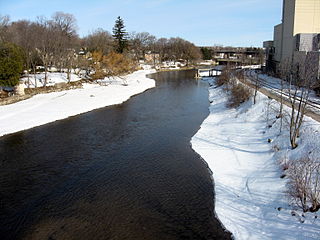
The Speed River is a river that flows through Wellington County and the Region of Waterloo in southwestern Ontario, Canada. It flows south from its source near Orton, through Guelph, where it is joined by the Eramosa River, then through the towns of Hespeler and Preston, finally uniting with the Grand River in north-west Cambridge.
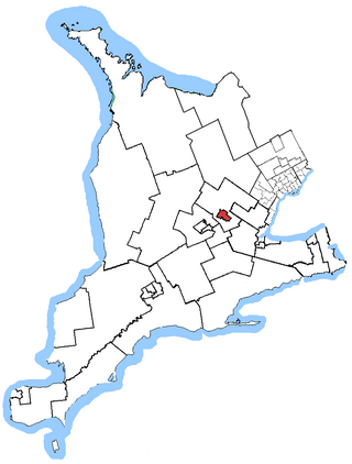
Guelph is a federal electoral district in Ontario, Canada, that has been represented in the House of Commons of Canada since 1979. This riding has had a Liberal MP since 1993.
Nestlé Pure Life is a brand of bottled water from Nestlé Waters globally and BlueTriton Brands in North America. The brand was first established in 1998 in Pakistan and is now available in 21 countries in Asia, the Americas, Africa, and Europe. In early April 2021, the sale of Nestlé Waters North America's bottling operations, including Nestlé Pure Life, to One Rock Capital Partners LLC and Metropoulos & Co. was concluded.
Guelph/Eramosa is a township located in Wellington County, in midwestern Ontario, Canada. It partly encircles the city of Guelph, surrounding it in a continuous arc from approximately northeast to south-southwest of the city. It is part of the Guelph census metropolitan area.

Guelph City Council is the governing body for the city of Guelph, Ontario.

A combination of aqueducts, reservoirs, and tunnels supplies fresh water to New York City. With three major water systems stretching up to 125 miles (201 km) away from the city, its water supply system is one of the most extensive municipal water systems in the world.
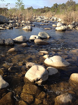
The Ventura River, in western Ventura County in southern California, United States, flows 16.2 miles (26.1 km) from its headwaters to the Pacific Ocean. The smallest of the three major rivers in Ventura County, it flows through the steeply sloped, narrow Ventura Valley, with its final 0.7 miles (1.1 km) through the broader Ventura River estuary, which extends from where it crosses under a 101 Freeway bridge through to the Pacific Ocean.

The Kensico Reservoir is a reservoir spanning the towns of Armonk and Valhalla, New York, located 3 miles (5 km) north of White Plains. It was formed by the original earth and gravel Kensico Dam constructed in 1885, which impounded waters from the Bronx and Byram rivers. In 1917, a new masonry dam was completed, replacing the old dam and expanding the water supply by bringing water from the Catskill Mountains over a distance of more than 100 miles.

The North Bay Aqueduct (NBA) is part of the California State Water Project that was built in two phases, Phase I (1967-1968) and Phase II (1985-1988). The aqueduct is 27.4 miles (44.1 km) long all in pipelines and serves Napa and Solano counties, California. The aqueduct provides water to about 500,000 residents in Solano and Napa.

Guelph Lake is a man-made reservoir on the Speed River, in the Township of Guelph/Eramosa. It is located upriver and slightly northeast of the city of Guelph, Ontario. The reservoir was created in 1974, with the construction of the Guelph Lake dam. The site is part of a 1,608 hectare conservation area maintained by the Grand River Conservation Authority.
Starkey Hill is the highest point in Puslinch Township, southwestern Ontario and is located southeast of Guelph, Ontario. The property is currently owned by the Grand River Conservation Authority and sports a 4 km loop hiking trail. Parking and access to the trail is located off Arkell Rd., 1 km east of Watson Rd. & the village of Arkell.

California's interconnected water system serves over 30 million people and irrigates over 5,680,000 acres (2,300,000 ha) of farmland. As the world's largest, most productive, and potentially most controversial water system, it manages over 40 million acre-feet (49 km3) of water per year.
Sonoma Water, formerly known as the Sonoma County Water Agency, maintains a water transmission system that provides naturally filtered Russian River water to more than 600,000 residents in portions of Sonoma County, California and Marin County, California. The Water Agency is a water wholesaler that sells potable water to nine cities and special districts that in turn sell drinking water to their residents. These cities and special districts are: the City of Santa Rosa, Rohnert Park, Cotati, Petaluma, Sonoma, the Town of Windsor, Valley of the Moon Water District, Marin Municipal Water District, and North Marin Water District.
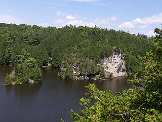
The Rockwood Conservation Area, also known as Rockwood Park, is a moderate sized conservation area situated in Rockwood, Ontario, Canada. Public operations run between May 1 and the first Sunday following Thanksgiving. A small admittance fee is required to access the park, but individuals or groups may purchase a membership that allows access to the eleven parks operated by the Grand River Conservation Authority. It is a popular destination for many local residents, with over 65,000 patrons visiting every year to enjoy the geological attractions of the park, as well as the historic ruins of the Rockwood Woolen Mills.

The Eramosa River Trail is a 4.1 km (2.5 mi) urban walking trail that runs alongside the Eramosa River in Guelph, Ontario, Canada, stretching from the Gordon Street covered bridge east to Stone Road. It is considered a section of the Royal Recreational Trail, and meets up with the Downtown and Speed River sections of that trail system at its western terminus.
References
- 1 2 "Grand River Watershed Characterization Report" (PDF). grandriver.ca. Retrieved 5 March 2021.
- 1 2 3 "Maintaining a Safe and Sustainable Supply to 2038 - Assessing Alternatives" (PDF). puslinch.ca. Retrieved 7 March 2021.
- 1 2 3 "GUELPH'S WATER SUPPLY MASTER PLAN UPDATE" (PDF). puslinch.ca. Retrieved 5 March 2021.
- ↑ "The News from Arkell". clarksoftomfad.ca. Retrieved 6 March 2021.
- ↑ "A Watershed Forest Plan for the Grand River" (PDF). grandriver.ca. Grand River Conservation Authority. Retrieved 5 March 2021.
- ↑ Butts, Ed (15 April 2017). "Wartime conspiracy believed Guelph's water supply could have been the target of enemy agents". Guelph Mercury. Retrieved 5 March 2021.
- 1 2 "Arkell Aqueduct maintenance project". guelph.ca. City of Guelph. Archived from the original on 30 October 2020. Retrieved 7 March 2021.
- ↑ Carstairs, Catherine (1 November 2015). "The Environmental Critique of Water Fluoridation" (PDF). Scientia Canadensis. 38. Retrieved 7 March 2021.
- ↑ Casey, Don. "ARKELL SPRINGS GROUNDS AND TRAILS CLOSED DUE TO COVID-19". gorba.ca. Guelph Off-Road Bicycling Association. Retrieved 4 March 2021.
- 1 2 "Arkell Spring Grounds". trailforks.com. Retrieved 5 March 2021.
- 1 2 3 "Arkell Springs forest management". guelph.ca. Retrieved 4 March 2021.
- ↑ Burton, Frank (December 2006). "City of Guelph Groundwater Resource Assessment Project". Project Unit 06-028. 37. doi:10.13140/RG.2.1.4395.6721 . Retrieved 7 March 2021.
- ↑ Mutti, Dennis; Anderson, Heather; Pett, Brian (December 2007). "Challenges in Implementing Enhanced Disinfection: Negotiating Operational Flexibility for the City of Guelph's Upgraded Water Supply System" (PDF). IUVA News. 9 (4): 19–24. Retrieved 6 March 2021.
- ↑ Turnour, Bob (2009). "Gravity-Based Pipeline Constructed With Concrete Pressure Pipe" (PDF). Concrete Pipe News. 61 (2): 6. Retrieved 7 March 2021.
- 1 2 3 Boreham, Paul (18 August 2016). "City says Arkell Springs project will meet growing demand for water in Guelph". Guelph Mercury. Retrieved 5 March 2021.
- ↑ "Surface water important to several communities" (PDF). The Grand: 6. 2006. Retrieved 5 March 2021.
- ↑ Kennedy, Celia Syliva Cassis (June 2017). Groundwater – Surface Water Interactions in the Discrete Fracture Networks of Bedrock Rivers (PDF) (PhD). University of Guelph. Retrieved 7 March 2021.
- ↑ "Grand River Basin Water Management Study" (PDF). grandriver.ca. Grand River Implementation Committee. Retrieved 5 March 2021.
- ↑ "Tier 2 Water Quantity Stress Assessment Report" (PDF). grandriver.ca. Grand River Conservation Authority. Retrieved 5 March 2021.
- ↑ "Grand River Watershed Water Management Plan" (PDF). grandriver.ca. Grand River Conservation Authority. Retrieved 5 March 2021.
- ↑ Baine, Janet (March 2007). "Parkers receive Watershed Award" (PDF). Grand Actions. 12 (2): 5–6. Retrieved 5 March 2021.
- ↑ "Arkell FAQ". gorba.ca. Guelph Off-Road Bicycling Association. Retrieved 5 March 2021.
| Canada | |
|---|---|
| United States |
|
| Mexico | |
| South America | |
| Australia | |
| New Zealand | |
| Africa | |
| Middle-East | |
| Europe | |
| Related articles | |
| Government | |
|---|---|
| Places | |
| Transportation | |
| Culture | |
| Media | |
| Nature | |