Related Research Articles
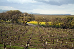
The Livermore Valley AVA is an American Viticultural Area in Alameda County, California, surrounding the city of Livermore in the Tri-Valley region. Both the AVA and the city are named after Robert Livermore, a landowner whose holdings encompassed the valley. The groundwater basin underlying the valley is the Livermore Basin, the largest sub-unit of which is the Mocho Subbasin. The Livermore Basin is one of five aquifers in the San Francisco Bay Area that supply most of the metropolitan Bay Area population. The entire Livermore Basin aquifer faces a concern over elevated total dissolved solids by the year 2020 due to an expanding human population leading to higher rates of return water flows to the aquifer containing certain salts.
Overdrafting is the process of extracting groundwater beyond the equilibrium yield of an aquifer. Groundwater is one of the largest sources of fresh water and is found underground. The primary cause of groundwater depletion is the excessive pumping of groundwater up from underground aquifers.
The Mocho Subbasin is the largest of the groundwater subbasins in the Livermore Valley watershed in Northern California. This subbasin is bounded to the west by the Livermore Fault Zone and to the east by the Tesla Fault. Some groundwater flow occurs across these fault boundaries, but flows are discontinuous below a depth of fifty feet across the Tesla Fault and south of the Arroyo Mocho channel across the Livermore Fault. Surface watercourses in this unit include Arroyo Valle and Arroyo Seco.
The Tesla Fault can be found in the northeastern Diablo Range, California. This fault is only semi-active.
Arroyo Mocho is a 34.7-mile-long (55.8 km) stream which originates in the far northeastern corner of Santa Clara County and flows northwesterly into eastern Alameda County, California. After traversing the cities of Livermore and Pleasanton it joins South San Ramon Creek to become Arroyo de la Laguna, which in turn flows to Alameda Creek and thence to San Francisco Bay.

Arroyo de la Laguna is a 7.5-mile-long (12.1 km) southward-flowing stream in Alameda County, California, United States which originates at the confluences of South San Ramon Creek and Arroyo Mocho. The Arroyo de la Laguna is fed by tributaries in the Amador Valley and certain eastern slope drainages of the Diablo Range; these tributaries include Arroyo Valle and Sinbad Creek. Arroyo del la Laguna is the major tributary to Alameda Creek which in turn flows into the San Francisco Bay.
South San Ramon Creek is a 9.3-mile-long (15.0 km) southward-flowing stream in Alameda County and southern Contra Costa County, in the East Bay region of northern California.
The Tassajara Formation is a geologic unit within the Livermore Valley of Northern California, United States. The formation surfaces only in the northern upland parts of the Livermore Valley and underlie the central part of the valley floor at a depth ranging from 250 feet (80 m) to 700 feet (200 m). The Tassajara Formation consists of sediments ranging from brown to gray mudstone, andesitic sandstone, conglomerate, and minor bentonitic and pumiceous tuff. In the northern San Ramon area, the Tassajara Formation underlies Quaternary valley fill material.
The Turlock Basin is a sub-basin of the San Joaquin Valley groundwater basin which occupies approximately 13,700 total square miles, making it the largest groundwater basin in California. The Turlock Basin makes up 542 square miles of this total. This aquifer is located within Merced and Stanislaus counties in the Central Valley bounded by the Tuolumne River to the north, the Merced River to the south and San Joaquin River to the west. The Sierra Nevada foothills bound the sub-basin to the east. Groundwater in the San Joaquin Valley occurs mostly in younger alluvial material. The Turlock Basin lies to the east of the city of Turlock. Groundwater in the Turlock Basin occurs in older alluvial deposits. Large portions of the San Joaquin Basin have experienced overdraft of water and infiltration of agricultural water pollutants, resulting in poor water quality.
The Bernal Subbasin is an aquifer located in the southwestern corner of Livermore Valley Groundwater Basin, Alameda County, California, United States. All of the groundwater in Livermore Valley moves toward the Bernal Subbasin, which is bounded on the east by Pleasanton Fault, on the north by the Park Fault, and on the west by the Calaveras Fault.(Earth Metrics, 1989) All the streams draining the Livermore Valley merge above the Bernal formation and exit this subbasin and Livermore Amador Valley via the Arroyo de la Laguna.
The Niles Cone is a groundwater basin in Alameda County, California, United States which is the source of drinking water for a sizeable human urban population in the East Bay. The land area corresponding to this groundwater basin is approximately 103 square miles; the Niles Cone Basin is bounded on the east by the Diablo Range and on the west by San Francisco Bay. Surface runoff in the Alameda Creek catchment basin accounts for much of the recharge of the Niles Cone. The Alameda County Water District is responsible for management of the Niles Cone aquifer and has developed water treatment plants and pipelines for the conveyance of its waters to urban users. The Alameda County Water District also performs water quality monitoring of the Niles Cone Basin for total dissolved solids and other parameters.
Aquifer storage and recovery (ASR) is the direct injection of surface water supplies such as potable water, reclaimed water (i.e. rainwater), or river water into an aquifer for later recovery and use. The injection and extraction is often done by means of a well. In areas where the rainwater cannot percolate the soil or where it is not capable of percolating it fast enough (i.e. urban areas) and where the rainwater is thus diverted to rivers, rainwater ASR could help to keep the rainwater within an area. ASR is used for municipal, industrial and agricultural purposes.
The Coachella Valley Water District is an independent special district formed in 1918, specifically to protect and conserve local water sources in the Coachella Valley. Since then, the district has grown into a multi-faceted agency that delivers irrigation and domestic (drinking) water, collects and recycles wastewater, provides regional storm water protection, replenishes the groundwater basin and promotes water conservation.
The Monterey Peninsula Water Project (MWPW) is a water management project seeking to meet water demands of Monterey residents. The major water source for Monterey is powered by the Carmel River, which is precipitation influenced and does not receive water perennially. In addition to the Carmel River, the Seaside Groundwater Basin is the only other form of water supply. Both watersheds have been protected under stiff regulation to significantly reduce water diversion, especially the Carmel River which has been severely affected by California's drought. The MPWP is the proposed answer to help meet current and future water demands, while dealing with these reductions from the Carmel River and Seaside Groundwater Basin. The main features of this project will include a desalination plant, slant wells that will draw water from underneath the sea floor along the coastline, and a 10-mile pipeline extending through the north part of Monterey to supply water to its residents. The goal throughout the planning of this new infrastructure is to protect ocean wildlife, while excess brine will be handled by the area's water pollution control agency. The total cost of this project is estimated to be 322 million dollars with 79 million coming from subsurface intake, 115 million from the desalination plant, and 128 million from the pipelines. The MPWP is divided into three main aspects which include desalination, aquifer storage and recovery, and groundwater replenishment.
The Sustainable Groundwater Management Act (SGMA) is a three-bill package that passed the California state legislature and was signed into California state law by Governor Jerry Brown in September 2014. Its purpose is to ensure better local and regional management of groundwater use and it seeks to have a sustainable groundwater management in California by 2042. It emphasizes local management and formed groundwater sustainability agencies (GSAs) from local and regional authorities who submitted groundwater sustainability plans (GSPs) to the state between 2020 and 2022.

Water reuse in California is the use of reclaimed water for beneficial use. As a heavily populated state in the drought-prone arid west, water reuse is developing as an integral part of water in California enabling both the economy and population to grow.
Borrego Valley Groundwater Basin, located in the very southern region of California, is one of the driest basins in the state. With climate change predicted to have strong effects into foreseeable future, the region is viewed with a skepticism in the sustainable use of water at current rates of consumption. Both natural and man-made geographic divisions within this basin allow for a closer inspection of the various management techniques implemented throughout the years, and provide a basis for what may be pursued for an uncertain future.

Principal aquifers of California are those principal aquifers of the United States that lie within the California state boundaries. Per the Oxford Dictionary of Environment and Conservation, an aquifer is a "body of permeable and/or porous rock that is underlain by impermeable rock and through which groundwater is able to flow."

The South Coast hydrologic region of California, is one of the 10 major hydrologic regions of California as identified by the California Department of Water Resources. The South Coast hydrologic region has a surface area of about 11,100 sq mi (29,000 km2), and includes all of Orange County, major portions of Los Angeles, Riverside, San Bernardino, San Diego, and Ventura counties, and a small portion of Santa Barbara County.
References
- ↑ Environmental Screening Analysis, 2127 Railroad Avenue, Livermore, California, Earth Metrics Inc report no. 7785, February, 1989
- ↑ Dublin Quadrangle, California, 7.5 minute series, U.S. Geological Survey, U.S. Government Printing Office, Washington DC (1980);
- ↑ Thomas L. Bonnie, What are the projected impacts of injecting reclaimed, reverse osmosis water into the Livermore-Amador Groundwater Basin? (2000)
