Related Research Articles

An aquifer is an underground layer of water-bearing permeable rock, rock fractures or unconsolidated materials. Groundwater can be extracted using a water well. The study of water flow in aquifers and the characterization of aquifers is called hydrogeology. Related terms include aquitard, which is a bed of low permeability along an aquifer, and aquiclude, which is a solid, impermeable area underlying or overlying an aquifer, the pressure of which could create a confined aquifer.

Henry is a city in Marshall County, Illinois, United States. The population was 2,464 at the 2010 census. It is part of the Peoria, Illinois Metropolitan Statistical Area.

The water table is the upper surface of the zone of saturation. The zone of saturation is where the pores and fractures of the ground are saturated with water.

Regolith is a blanket of unconsolidated, loose, heterogeneous superficial deposits covering solid rock. It includes dust, broken rocks, and other related materials and is present on Earth, the Moon, Mars, some asteroids, and other terrestrial planets and moons.

Groundwater is the water present beneath Earth's surface in soil pore spaces and in the fractures of rock formations. A unit of rock or an unconsolidated deposit is called an aquifer when it can yield a usable quantity of water. The depth at which soil pore spaces or fractures and voids in rock become completely saturated with water is called the water table. Groundwater is recharged from the surface; it may discharge from the surface naturally at springs and seeps, and can form oases or wetlands. Groundwater is also often withdrawn for agricultural, municipal, and industrial use by constructing and operating extraction wells. The study of the distribution and movement of groundwater is hydrogeology, also called groundwater hydrology.

Hydrogeology is the area of geology that deals with the distribution and movement of groundwater in the soil and rocks of the Earth's crust. The terms groundwater hydrology, geohydrology, and hydrogeology are often used interchangeably.

The Teays River was a major preglacial river that drained much of the present Ohio River watershed, but took a more northerly downstream course. Traces of the Teays across northern Ohio and Indiana are represented by a network of river valleys. The largest still existing contributor to the former Teays River is the Kanawha River in West Virginia, which is itself an extension of the New River. The name Teays from the Teays Valley is associated with this buried valley since 1910. The more appropriate name would be ancestral Kanawha Valley. The term Teays is used when discussing the buried portion of the ancestral Kanawha River. The Teays was comparable in size to the Ohio River. The River's headwaters were near Blowing Rock, North Carolina; it then flowed through Virginia, West Virginia, Ohio, Indiana and Illinois.. The largest tributary to the Teays River was the Old Kentucky River, which extended from southern Kentucky through Frankfort and subsequently flowed northeast, meeting other tributaries and eventually joining the Teays.

The Driftless Area is a region in southwestern Wisconsin, southeastern Minnesota, northeastern Iowa, and the extreme northwestern corner of Illinois, of the American Midwest. The region escaped the flattening effects of glaciation during the last ice age and is consequently characterized by steep, forested ridges, deeply carved river valleys, and karst geology characterized by spring-fed waterfalls and cold-water trout streams. Ecologically, the Driftless Area's flora and fauna are more closely related to those of the Great Lakes region and New England than those of the broader Midwest and central Plains regions. Colloquially, the term includes the incised Paleozoic Plateau of southeastern Minnesota and northeastern Iowa. The region includes elevations ranging from 603 to 1,719 feet at Blue Mound State Park and covers 24,000 square miles (62,200 km2). The rugged terrain is due both to the lack of glacial deposits, or drift, and to the incision of the upper Mississippi River and its tributaries into bedrock.
Fossil water or paleowater is an ancient body of water that has been contained in some undisturbed space, typically groundwater in an aquifer, for millennia. Other types of fossil water can include subglacial lakes, such as Antarctica's Lake Vostok, and even ancient water on other planets.

The Dissected Till Plains are physiographic sections of the Central Lowlands province, which in turn is part of the Interior Plains physiographic division of the United States, located in southern and western Iowa, northeastern Kansas, the southwestern corner of Minnesota, northern Missouri, eastern Nebraska, and southeastern South Dakota.
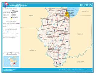
Illinois is in the midwestern United States. Surrounding states are Wisconsin to the north, Iowa and Missouri to the west, Kentucky to the south, and Indiana to the east. Illinois also borders Michigan, but only via a northeastern water boundary in Lake Michigan. Nearly the entire western boundary of Illinois is the Mississippi River, except for a few areas where the river has changed course. Illinois' southeastern and southern boundary is along the Wabash River and the Ohio River. Whereas, its northern boundary and much of its eastern boundary are straight survey lines. Illinois has a maximum north-south distance of 390 miles and 210 miles east-west. Its total area is 57,918 square miles (150,010 km2).
The Mahomet Aquifer is the most important aquifer in east-central Illinois. Composed of sand and gravel, it is part of the buried Mahomet Bedrock Valley. It underlies 15 counties and ranges from 50 to 200 feet thick. It supplies over 100,000,000 US gallons (380,000 m3) per day of groundwater for public water use, industrial supply, and irrigation.
Surficial aquifers are shallow aquifers typically less than 50 feet (15 m) thick, but larger surficial aquifers of about 60 feet (18 m) have been mapped. They mostly consist of unconsolidated sand enclosed by layers of limestone, sandstone or clay and the water is commonly extracted for urban use. The aquifers are replenished by streams and from precipitation and can vary in volume considerably as the water table fluctuates. Being shallow, they are susceptible to contamination by fuel spills, industrial discharge, landfills, and saltwater. Parts of southeastern United States are dependent on surficial aquifers for their water supplies.
A buried valley is an ancient river or stream valley that has been filled with glacial or unconsolidated sediment. This sediment is made up of predominantly gravel and sand, with some silt and clay. These types of sediments can often store and transmit large amounts of groundwater and act as a local aquifer.

The Kankakee Torrent was a catastrophic flood that occurred about 19,000 BP calibrated years ago in the Midwestern United States. It resulted from a breach of moraines forming a large glacial lake fed by the melting of the Late Wisconsin Laurentide Ice Sheet. The point of origin of the flood was Lake Chicago. The landscape south of Chicago still shows the effects of the torrent, particularly at Kankakee River State Park and on the Illinois River at Starved Rock State Park.

The Ogallala Formation is a Miocene to early Pliocene geologic formation in the central High Plains of the western United States and the location of the Ogallala Aquifer. In Nebraska and South Dakota it is also classified as the Ogallala Group. Notably, it records the North American Land Mammal Ages (NALMAs) Hemphillian, Clarendonian, and Barstovian. It also includes an excellent record of grass seeds and other plant seeds, which can be used for biostratigraphic dating within the formation. The Ogallala Formation outcrops of Lake Meredith National Recreation Area preserve fish fossils. Similar specimens from the same unit are found at Alibates Flint Quarries National Monument in Texas.
The Calumet Aquifer is an aquifer underlying the land at the extreme southern tip of Lake Michigan. It underlies the northern third of Lake County, Indiana and the northern tenth of Porter County, as well as small parts of LaPorte County and Cook County, Illinois. It is notable chiefly for its high levels of contamination by industrial waste from factories and toxic waste dumps in the Calumet Region. It is bordered to the south by Valparaiso Moraine Aquifer, and to the north by Lake Michigan. It is underlain by a Silurian bedrock aquifer complex.
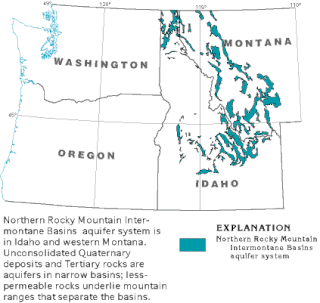
The Northern Rocky Mountain Intermontane Basins aquifer system is composed largely of unconsolidated sand lying under western Montana, Idaho and a small part of Washington. These shallow aquifers are not connected as a whole, body of water, but narrow glacial deposits unified by a common geologic history.
The geology of Mississippi includes some deep igneous and metamorphic crystalline basement rocks from the Precambrian known only from boreholes in the north, as well as sedimentary sequences from the Paleozoic. The region long experienced shallow marine conditions during the tectonic evolutions of the Mesozoic and Cenozoic, as coastal plain sediments accumulated up to 45,000 feet thick, including limestone, dolomite, marl, anhydrite and sandstone layers, with some oil and gas occurrences and the remnants of Cretaceous volcanic activity in some locations.
Groundwater in Nigeria is widely used for domestic, agricultural, and industrial supplies. The Joint Monitoring Programme for Water Supply and Sanitation estimate that in 2018 60% of the total population were dependent on groundwater point sources for their main drinking water source: 73% in rural areas and 45% in urban areas. The cities of Calabar and Port Harcourt are totally dependent on groundwater for their water supply.
References
- ↑ Kelly, Walt (February 1, 2016). Water Supply Planning: Middle Illinois Progress Report (PDF) (Report). Retrieved 2016-10-03.
Groundwater in the Peoria Region. Horberg, Leland, Max Suter, and T.E. Larson, 1950 Illinois State Water Survey, Bulletin 39, Champaign, IL 128 p.
Water Resources in Peoria-Pekin District. Buswell, A.M, 1940 Illinois State Water Survey, Champaign, Bulletin 33, IL 114 p.
| Canada | |
|---|---|
| United States |
|
| Mexico | |
| South America | |
| Australia | |
| Africa | |
| Middle-East | |
| Europe | |
| Related articles | |