Related Research Articles

An aquifer is an underground layer of water-bearing, permeable rock, rock fractures, or unconsolidated materials. Groundwater from aquifers can be extracted using a water well. Water from aquifers can be sustainably harvested through the use of qanats. Aquifers vary greatly in their characteristics. The study of water flow in aquifers and the characterization of aquifers is called hydrogeology. Related terms include aquitard, which is a bed of low permeability along an aquifer, and aquiclude, which is a solid, impermeable area underlying or overlying an aquifer, the pressure of which could create a confined aquifer. The classification of aquifers is as follows: Saturated versus unsaturated; aquifers versus aquitards; confined versus unconfined; isotropic versus anisotropic; porous, karst, or fractured; transboundary aquifer.

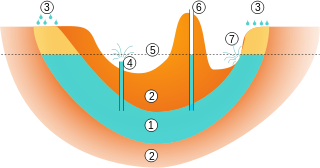
The water table is the upper surface of the zone of saturation. The zone of saturation is where the pores and fractures of the ground are saturated with water. It can also be simply explained as the depth below which the ground is saturated.

Groundwater is the water present beneath Earth's surface in rock and soil pore spaces and in the fractures of rock formations. About 30 percent of all readily available freshwater in the world is groundwater. A unit of rock or an unconsolidated deposit is called an aquifer when it can yield a usable quantity of water. The depth at which soil pore spaces or fractures and voids in rock become completely saturated with water is called the water table. Groundwater is recharged from the surface; it may discharge from the surface naturally at springs and seeps, and can form oases or wetlands. Groundwater is also often withdrawn for agricultural, municipal, and industrial use by constructing and operating extraction wells. The study of the distribution and movement of groundwater is hydrogeology, also called groundwater hydrology.
Hydrothermal circulation in its most general sense is the circulation of hot water. Hydrothermal circulation occurs most often in the vicinity of sources of heat within the Earth's crust. In general, this occurs near volcanic activity, but can occur in the shallow to mid crust along deeply penetrating fault irregularities or in the deep crust related to the intrusion of granite, or as the result of orogeny or metamorphism. Hydrothermal circulation often results in hydrothermal mineral deposits.

Hydrogeology is the area of geology that deals with the distribution and movement of groundwater in the soil and rocks of the Earth's crust. The terms groundwater hydrology, geohydrology, and hydrogeology are often used interchangeably.
An artesian well is a well that brings groundwater to the surface without pumping because it is under pressure within a body of rock and/or sediment known as an aquifer. When trapped water in an aquifer is surrounded by layers of impermeable rock or clay, which apply positive pressure to the water, it is known as an artesian aquifer. If a well were to be sunk into an artesian aquifer, water in the well-pipe would rise to a height corresponding to the point where hydrostatic equilibrium is reached.
In hydrogeology, an aquifer test is conducted to evaluate an aquifer by "stimulating" the aquifer through constant pumping, and observing the aquifer's "response" (drawdown) in observation wells. Aquifer testing is a common tool that hydrogeologists use to characterize a system of aquifers, aquitards and flow system boundaries.
Saltwater intrusion is the movement of saline water into freshwater aquifers, which can lead to groundwater quality degradation, including drinking water sources, and other consequences. Saltwater intrusion can naturally occur in coastal aquifers, owing to the hydraulic connection between groundwater and seawater. Because saline water has a higher mineral content than freshwater, it is denser and has a higher water pressure. As a result, saltwater can push inland beneath the freshwater. In other topologies, submarine groundwater discharge can push fresh water into saltwater.

Hydraulic head or piezometric head is a specific measurement of liquid pressure above a vertical datum.
In hydrology, there are two similar but distinct definitions in use for the word drawdown:
Used in hydrogeology, the groundwater flow equation is the mathematical relationship which is used to describe the flow of groundwater through an aquifer. The transient flow of groundwater is described by a form of the diffusion equation, similar to that used in heat transfer to describe the flow of heat in a solid. The steady-state flow of groundwater is described by a form of the Laplace equation, which is a form of potential flow and has analogs in numerous fields.
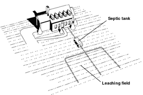
Septic drain fields, also called leach fields or leach drains, are subsurface wastewater disposal facilities used to remove contaminants and impurities from the liquid that emerges after anaerobic digestion in a septic tank. Organic materials in the liquid are catabolized by a microbial ecosystem.
Pore water pressure refers to the pressure of groundwater held within a soil or rock, in gaps between particles (pores). Pore water pressures below the phreatic level of the groundwater are measured with piezometers. The vertical pore water pressure distribution in aquifers can generally be assumed to be close to hydrostatic.

Groundwater recharge or deep drainage or deep percolation is a hydrologic process, where water moves downward from surface water to groundwater. Recharge is the primary method through which water enters an aquifer. This process usually occurs in the vadose zone below plant roots and is often expressed as a flux to the water table surface. Groundwater recharge also encompasses water moving away from the water table farther into the saturated zone. Recharge occurs both naturally and through anthropogenic processes, where rainwater and or reclaimed water is routed to the subsurface.
Groundwater models are computer models of groundwater flow systems, and are used by hydrologists and hydrogeologists. Groundwater models are used to simulate and predict aquifer conditions.
Well drainage means drainage of agricultural lands by wells. Agricultural land is drained by pumped wells to improve the soils by controlling water table levels and soil salinity.

A well is an excavation or structure created in the ground by digging, driving, or drilling to access liquid resources, usually water. The oldest and most common kind of well is a water well, to access groundwater in underground aquifers. The well water is drawn up by a pump, or using containers, such as buckets or large water bags that are raised mechanically or by hand. Water can also be injected back into the aquifer through the well. Wells were first constructed at least eight thousand years ago and historically vary in construction from a simple scoop in the sediment of a dry watercourse to the qanats of Iran, and the stepwells and sakiehs of India. Placing a lining in the well shaft helps create stability, and linings of wood or wickerwork date back at least as far as the Iron Age.

Fracking is a well stimulation technique involving the fracturing of bedrock formations by a pressurized liquid. The process involves the high-pressure injection of "fracking fluid" into a wellbore to create cracks in the deep-rock formations through which natural gas, petroleum, and brine will flow more freely. When the hydraulic pressure is removed from the well, small grains of hydraulic fracturing proppants hold the fractures open.
Groundwater pollution occurs when pollutants are released to the ground and make their way into groundwater. This type of water pollution can also occur naturally due to the presence of a minor and unwanted constituent, contaminant, or impurity in the groundwater, in which case it is more likely referred to as contamination rather than pollution. Groundwater pollution can occur from on-site sanitation systems, landfill leachate, effluent from wastewater treatment plants, leaking sewers, petrol filling stations, hydraulic fracturing (fracking) or from over application of fertilizers in agriculture. Pollution can also occur from naturally occurring contaminants, such as arsenic or fluoride. Using polluted groundwater causes hazards to public health through poisoning or the spread of disease.

A well cluster, also referred to as a monitoring well cluster, consists of multiple co-located monitoring wells that are constructed with intakes at different depths in the subsurface. The purpose of a well cluster is to provide groundwater samples from discrete depths at approximately the same location, and/or to measure the vertical pressure gradient to calculate the vertical component of groundwater flow. Water levels can be measured in each individual monitoring well, providing vertical profiles of groundwater pressure. The pressure difference between the groundwater table and the potentiometric surface in a submerged well can. A shallow well is used to measure the water table, and is equilibrated to atmospheric pressure. A deeper well, or piezometer, measured the potentiometric surface, determined by the water level observed when submerged and sealed. The associated change in pressure between the shallow well and piezometer, and the corresponding length, usually taken as the distance between the center of the two well screens, can be applied to Darcy's Law to calculate the vertical groundwater flow.
References
- Earth: Portrait of a Planet; Second edition; Stephen Marshak, 2005 W.W. Norton & Company, Inc (Page 604–605)
- ↑ Younger, Paul (2007). Groundwater in the Environment. Oxford, UK: Blackwell Publishing Ltd. ISBN 978-1-4051-2143-9.
| | This classical mechanics–related article is a stub. You can help Wikipedia by expanding it. |
| | This water supply–related article is a stub. You can help Wikipedia by expanding it. |