Idylwild Park

Last updated
Idylwild Park

IdylGate.jpg

Entrance gate, Idylwild Park.
Type Private park
Location Cambridge, Ontario, Canada
Coordinates 43°24′56″N80°20′24″W / 43.415542°N 80.340091°W / 43.415542; -80.340091 Coordinates: 43°24′56″N80°20′24″W / 43.415542°N 80.340091°W / 43.415542; -80.340091
Created 1899 (1899)
Operated by GP&H Street Railway
Status Permanently closed in 1916 (1916)

Idylwild Park was a park located on the Speed River in what is now Cambridge, Ontario, Canada. [1] It attracted people from across Southwestern Ontario and the Golden Horseshoe, via the Grand Trunk Railway and the Galt, Preston & Hespeler (GP&H) Street Railway.

Park area of open space used for recreation or conservation

A park is an area of natural, semi-natural or planted space set aside for human enjoyment and recreation or for the protection of wildlife or natural habitats. Urban parks are green spaces set aside for recreation inside towns and cities. National parks and Country parks are green spaces used for recreation in the countryside. State parks and Provincial parks are administered by sub-national government states and agencies. Parks may consist of grassy areas, rocks, soil and trees, but may also contain buildings and other artifacts such as monuments, fountains or playground structures. Many parks have fields for playing sports such as soccer, baseball and football, and paved areas for games such as basketball. Many parks have trails for walking, biking and other activities. Some parks are built adjacent to bodies of water or watercourses and may comprise a beach or boat dock area. Urban parks often have benches for sitting and may contain picnic tables and barbecue grills.

Speed River river in Canada

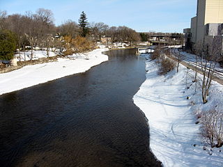
The Speed River is a river that flows through Wellington County and the Region of Waterloo in southwestern Ontario, Canada. It flows south from its source near Orton, through Guelph, where it is joined by the Eramosa River, then through the towns of Hespeler and Preston, finally uniting with the Grand River in north-west Cambridge.

Cambridge, Ontario City in Ontario, Canada

Cambridge is a city located in Southern Ontario at the confluence of the Grand and Speed rivers in the Regional Municipality of Waterloo, Ontario, Canada. It was formed in 1973 by the amalgamation of Galt, Preston, Hespeler, the settlement of Blair and a small portion of surrounding townships.

Contents

Idylwild fell between the Town of Preston and the Town of Hespeler, just north of where the MacDonald-Cartier Freeway crosses the river today. [1]

Preston is a community in Cambridge, Ontario, Canada in the Regional Municipality of Waterloo, Ontario. Prior to 1973 it was an independent city, incorporated in 1915, but amalgamation with the town of Hespeler, Ontario, the city of Galt, Ontario and the village of Blair formed the new municipality of Cambridge. Parts of the surrounding townships were also included. No population data is available for the former Preston since the Census reports cover only the full area of Cambridge, though the combined population of the census tracts covering the majority of Preston reported a population of 20,008 as of the 2016 Canada Census. The first mayor of Cambridge was Claudette Millar.

Hespeler, Ontario Dissolved town in Ontario, Canada

Hespeler is a neighbourhood and former town within Cambridge, Ontario, located along the Speed River in the Regional Municipality of Waterloo, Ontario, Canada. In 1973, Hespeler, Preston, Galt, and the hamlet of Blair were amalgamated in 1973 to form the City of Cambridge. The first mayor of Cambridge was Claudette Millar.

Ontario Highway 401 highway in Ontario

King's Highway 401, commonly referred to as Highway 401 and also known by its official name as the Macdonald–Cartier Freeway or colloquially as the four-oh-one, is a controlled-access 400-series highway in the Canadian province of Ontario. It stretches 828 kilometres (514 mi) from Windsor in the west to the Ontario–Quebec border in the east. The part of Highway 401 that passes through Toronto is North America's busiest highway, and one of the widest. Together with Quebec Autoroute 20, it forms the road transportation backbone of the Quebec City–Windsor Corridor, along which over half of Canada's population resides and is also a Core Route in the National Highway System of Canada. The route is maintained by the Ministry of Transportation of Ontario (MTO) and patrolled by the Ontario Provincial Police. The speed limit is 100 km/h (62 mph) throughout its length, with the only exceptions being the posted 80 km/h (50 mph) limit westbound in Windsor and in most construction zones.

History

Idylwild Park was opened in 1899 by operators of the GP&H Street Railway. [1] Their purpose for establishing it was to stimulate rail travel during the weekends. It was accessed exclusively via the Preston-Hespeler line, which was opened the same year. The Preston Junction connected that line to the Grand Trunk Railroad. Park-goers were given ribbons to wear that identified them as patrons of the park and rail-line.

Grand River Railway

The Grand River Railway was an electric railway in what is now the Regional Municipality of Waterloo, in Southwestern Ontario. It was an example of a radial railway.

"A wooded area with tall elms, maples and evergreens - a perfect setting for one of, if not the, most popular playground, picnic and recreational centres in the district. Popular dances of the time included quadrilles, waltzes, two-steps and the cake walk. It was not at all uncommon for the railway to shunt in from Preston Junction a train load of picnickers from as far away as Hamilton, bringing hundreds to enjoy the great out-of-doors in the wilds of Idylwild." - O.A. Kummer [1]
Man piloting a Jon boat on the Speed River, Idylwild Park. A footbridge spanning the river is in the background. IdylBoat.jpg
Man piloting a Jon boat on the Speed River, Idylwild Park. A footbridge spanning the river is in the background.

Straddling the Speed River within Hunt Club Valley, the park encompassed lands on both banks, as well as an islet between them. Wooden footbridges were erected to facilitate travel across the river and to the islet. The bridges were disassembled in the autumn, to accommodate for ice and floods, and then reassembled in the spring.

Islet A very small island

An islet is a very small island.

Footbridge bridge designed for pedestrians and in some cases cyclists, animal traffic and horse riders, rather than vehicular traffic

A footbridge is a bridge designed solely for pedestrians. While the primary meaning for a bridge is a structure which links "two points at a height above the ground", a footbridge can also be a lower structure, such as a boardwalk, that enables pedestrians to cross wet, fragile, or mashy land. Bridges range from stepping stones–possibly the earliest man-made structure to "bridge" water–to elaborate steel structures. Another early bridge would have been simply a fallen tree. In some cases a footbridge can be both functional and a beautiful work of art.

Autumn one of the Earths four temperate seasons, occurring between summer and winter

Autumn, also known as fall in American English and sometimes in Canadian English, is one of the four temperate seasons. Autumn marks the transition from summer to winter, in September or March, when the duration of daylight becomes noticeably shorter and the temperature cools considerably. One of its main features in temperate climates is the shedding of leaves from deciduous trees.

Additionally, the park featured a refreshment booth, a baseball diamond and a spring, as well as two pavilions, swings, boardwalks and docks.

Baseball Sport

Baseball is a bat-and-ball game played between two opposing teams who take turns batting and fielding. The game proceeds when a player on the fielding team, called the pitcher, throws a ball which a player on the batting team tries to hit with a bat. The objectives of the offensive team are to hit the ball into the field of play, and to run the bases—having its runners advance counter-clockwise around four bases to score what are called "runs". The objective of the defensive team is to prevent batters from becoming runners, and to prevent runners' advance around the bases. A run is scored when a runner legally advances around the bases in order and touches home plate. The team that scores the most runs by the end of the game is the winner.

The nickname "Mosquito Park" came to be assumed for the park, [1] as mosquitos thrived in the area due to the surrounding wetlands.

Nickname informal name of a person, place, or thing, for affection or ridicule

A nickname is a substitute for the proper name of a familiar person, place, or thing - commonly used for affection.

Mosquito family of insects

Mosquitoes are a group of about 3500 species of small insects that are a type of fly. Within that order they constitute the family Culicidae. The word "mosquito" is Spanish for "little fly". Mosquitoes have a slender segmented body, a pair of wings, three pairs of long hair-like legs, feathery antennae, and elongated mouthparts.

Wetland A land area that is permanently or seasonally saturated with water

A wetland is a distinct ecosystem that is inundated by water, either permanently or seasonally, where oxygen-free processes prevail. The primary factor that distinguishes wetlands from other land forms or water bodies is the characteristic vegetation of aquatic plants, adapted to the unique hydric soil. Wetlands play a number of functions, including water purification, water storage, processing of carbon and other nutrients, stabilization of shorelines, and support of plants and animals. Wetlands are also considered the most biologically diverse of all ecosystems, serving as home to a wide range of plant and animal life. Whether any individual wetland performs these functions, and the degree to which it performs them, depends on characteristics of that wetland and the lands and waters near it. Methods for rapidly assessing these functions, wetland ecological health, and general wetland condition have been developed in many regions and have contributed to wetland conservation partly by raising public awareness of the functions and the ecosystem services some wetlands provide.

In 1916, Idylwild Park was closed permanently. It has been suggested that the growing popularity of the automobile, the First World War and the establishment of Riverside Park in the nearby Town of Preston contributed to the closure of the park. [1]

Present day

The landscape of the site has since either grown over, eroded or been developed. The gates, pavilions, bridges and other structures are no longer present. The mosquitos, however, remain.

A portion of the former site, along the southern bank of the Speed River, is now part of a conservation area that is owned and managed by the Grand River Conservation Authority. [2] The City of Cambridge's Mill Run Trail passes through, making use of the dismantled rail-bed. [3]

The islet and most of the northern bank are private property.

A nearby subdivision, Idylwild Estates, is named after the park.

See also

Citations

  1. 1 2 3 4 5 6 Bean. 2005.
  2. Jacob. 2004.
  3. Mill Run Trail brochure. Corporation of the City of Cambridge.

Related Research Articles

Regional Municipality of Waterloo Upper-tier regional municipality in Ontario, Canada

The Regional Municipality of Waterloo is a regional municipality located in Southern Ontario, Canada. It consists of the cities of Kitchener, Waterloo and Cambridge,, and the townships of Wellesley, Woolwich, Wilmot, and North Dumfries. It is often referred to as the Region of Waterloo or Waterloo Region. The region is 1,369 square kilometres in size and its regional seat of government is in Kitchener.

Grand River Transit Bus operator in Waterloo Region, Ontario

Grand River Transit (GRT) is the public transport operator for the Region of Waterloo, Ontario, Canada. It operates daily bus services in the region, primarily in the cities of Kitchener, Waterloo, and Cambridge.

Waterloo County, Ontario Former County

Waterloo County, created in 1853 and dissolved in 1973, was the forerunner of the Regional Municipality of Waterloo in Ontario, Canada. Situated on a subset of land within the Haldimand Tract, the traditional territory of the Attawandaron, Anishinaabe and Haudenosaunee peoples, Waterloo County consisted of five townships: Woolwich, Wellesley, Wilmot, Waterloo, and North Dumfries. The major population centres were Waterloo, Kitchener, Preston, Hespeler, Blair, and Doon in Waterloo township; Galt in North Dumfries; Elmira in Woolwich; and New Hamburg in Wilmot. All are now part of the Regional Municipality.

St. Marys, Ontario Town in Ontario, Canada

St. Marys is a town in southwestern Ontario, Canada. It is located at the junction of Thames River and Trout Creek southwest of Stratford, and is surrounded by the Township of Perth South in Perth County, Ontario. St. Marys operates under its own municipal government that is independent from the County's government. Nonetheless, the three entities "enjoy a large degree of collaboration and work together to grow the region as a leading location for industry and people". Census data published for Perth County by Statistics Canada includes St. Marys and most Perth County publications also do, at least in some sections of the document.

Grand Trunk Western Railroad

The Grand Trunk Western Railroad Company is an American subsidiary of the Canadian National Railway operating in Michigan, Illinois, Indiana and Ohio. Since a corporate restructuring in 1971 the railroad has been under CN's subsidiary holding company the Grand Trunk Corporation. Grand Trunk Western's routes are part of CN's Michigan Division. Its primary mainline between Chicago, Illinois, and Port Huron, Michigan, serves as a connection between railroad interchanges in Chicago and rail lines in eastern Canada and the Northeastern United States. The railroad's extensive trackage in Detroit and across southern Michigan has made it an essential link for the automotive industry as a hauler of parts and automobiles from manufacturing plants.

Galt is a community in Cambridge, Ontario, Canada, in the Regional Municipality of Waterloo, Ontario on the Grand River. Prior to 1973 it was an independent city, incorporated in 1915, but amalgamation with the town of Hespeler, Ontario, the town of Preston, Ontario and the village of Blair formed the new municipality of Cambridge. Parts of the surrounding townships were also included. The first mayor of Cambridge was Claudette Millar.

The Ottawa, Arnprior and Parry Sound Railway, or OA&PS, is a historic railway that operated in central and eastern Ontario, Canada from 1897 until 1959. It was, for a time, the busiest railway route in Canada, carrying both timber and wood products from today's Algonquin Provincial Park areas, as well as up to 40% of the grain traffic from the Canadian west from Depot Harbour at Parry Sound through to the St. Lawrence River valley.

The Hamilton–Brantford–Cambridge Trails are a network of multi-use interurban recreational rail trails connecting several municipalities in Southern Ontario, Canada. The trails are part of the Southern Ontario Loop of the Trans Canada Trail. From end to end, the trail is 80 kilometres (50 mi) long, running from Cambridge South through Paris to Brantford and then East to central Hamilton.

Ion rapid transit mass rapid transit network in Waterloo, Canada

Ion, stylized as ION, is an integrated mass transit network currently in the testing phase in the Regional Municipality of Waterloo in Ontario, Canada. It will be operated by Keolis and will be part of the Grand River Transit (GRT) system, supplementing and partially replacing GRT's existing Route 200 iXpress bus service. The first phase will run between the north end of Waterloo, Ontario, and the south end of Kitchener, with an estimated start date of spring 2019. A future extension to the downtown Galt area of Cambridge is planned but construction may not begin on that line until 2025.

Preston High School (Ontario)

Preston High School, located on the bank of the Grand River in Cambridge, Ontario, first opened in 1934. Feeder schools are William G. Davis Senior Public School, Clemens Mill Public School and Silverheights Public School in Cambridge and Doon Public School in Kitchener. It is one of sixteen secondary schools in the Waterloo Region District School Board. In 2007, approximately 300 students entered grade 9 and the total enrolment was 1253, which is a below average number compared to other schools in the Waterloo region. For the 2018-2019 academic year, the administration includes Paula Bender as principal and vice principals Ryan Gibb and Phyllis Macleod.

Jacob Hespeler was a prominent businessman in Canada West and the founder of the town of Hespeler .

Preston & Berlin Street Railway

The Preston & Berlin Electric Railway was an interurban streetcar service offered covering the 12.68 kilometres (7.88 mi) between the cities of Preston, Ontario and Berlin, Ontario . The company was formed in 1894, but lay dormant, until 1900, when construction began. The company began operation in 1904.

Galt, Preston and Hespeler Street Railway

The Galt, Preston and Hespeler Street Railway was an interurban streetcar service connecting the three nearby cities of Galt, Ontario and Preston, Ontario, and later, also connecting Hespeler, Ontario. The firm was organized in 1890, and began operation in 1894. In 1908 it merged with the Preston & Berlin Street Railway, with the new entity called the Berlin, Waterloo, Wellesley & Lake Huron Railway Company.

The first Preston and Berlin Railway was a conventional railway, opened for operation in 1957. Berlin, Ontario (now Kitchener, Ontario, and Preston, Ontario, were only 13 kilometres apart, but the route required a bridge over the Grand River.

References