Rocky River (Ohio)

Last updated
Rocky River
Rocky River Lakewood Ohio.jpg
A shale cliff along the Rocky River in the Cleveland Metroparks Rocky River Reservation, located on the boundary of the cities of Lakewood and Rocky River, Ohio.
Location
Country United States of America
Physical characteristics
Source 
  locationConfluence of East Branch Rocky River and West Branch Rocky River, between Cleveland and North Olmsted, Cuyahoga County, Ohio
  coordinates 41°24′23″N81°53′14″W / 41.40639°N 81.88722°W / 41.40639; -81.88722
  elevation657 feet (200 m) AMSL
Mouth  
  location
Lake Erie between Lakewood and Rocky River, Cuyahoga County, Ohio
  coordinates
41°29′28″N81°50′21″W / 41.49111°N 81.83917°W / 41.49111; -81.83917 Coordinates: 41°29′28″N81°50′21″W / 41.49111°N 81.83917°W / 41.49111; -81.83917
  elevation
571 feet (174 m) AMSL
Basin features
GNIS ID 1066928
Aerial view, looking southerly, of the river's mouth and surrounding area of discharge into Lake Erie, in Rocky River. At top, the Clifton Park-West Lake Bridge carries U.S. Route 6 across the river. At center is a derrick boat operated by the U.S. Army Corps of Engineers, which dredges the navigation channel and maintains the breakwater. Rocky River Ohio aerial view.jpg
Aerial view, looking southerly, of the river's mouth and surrounding area of discharge into Lake Erie, in Rocky River. At top, the Clifton Park-West Lake Bridge carries U.S. Route 6 across the river. At center is a derrick boat operated by the U.S. Army Corps of Engineers, which dredges the navigation channel and maintains the breakwater.
A bend in the Rocky River and adjoining riverbanks are seen in this photo taken from a bridge on the Cleveland-Rocky River border in the Rocky River Reservation. Rocky River Cleveland Ohio.jpg
A bend in the Rocky River and adjoining riverbanks are seen in this photo taken from a bridge on the Cleveland-Rocky River border in the Rocky River Reservation.
Low water ford bridge over the East Branch Rocky River in the Millstream Reservation. Millstream Ford Bridge.jpg
Low water ford bridge over the East Branch Rocky River in the Millstream Reservation.

The Rocky River is a relatively short river in Cuyahoga County, Ohio that forms the natural western boundaries of Cleveland and the suburb of Lakewood with the suburbs of Fairview Park and Rocky River. The latter community is named after the river. To the south of Fairview Park and west of Cleveland Hopkins International Airport, the river forms the natural boundary between the suburb of Brook Park and the communities of North Olmsted and Olmsted Township. Ranked by Field & Stream as one of the top steelhead trout rivers in the world, the Rocky River is the center of the Rocky River Reservation of the Cleveland Metroparks.

Contents

Watershed

The river itself is formed by the confluence of the East and West Branches in North Olmsted at Cedar Point Hill (unrelated to the theme park of the same name north of Sandusky), just west of Cleveland Hopkins International Airport.

The headwaters of the larger West Branch are predominantly located in Medina County, where the north and south branches merge to form the west branch and flow northward through, among other locales, the town of Olmsted Falls. The East Branch first begins in the Cleveland suburb of North Royalton, near State Rd. and Wallings Rd. The flow here is actually to the south, through Richfield and Hinckley Townships. The East Branch wraps around Whipp's Ledges in Hinckley Township and begins its north-northwest journey. Hinckley Lake is actually the East Branch Rocky, impounded in the late 1920s/early 1930s. On its course back through southwestern Cuyahoga County, the East Branch is an important local feature in the cities of Strongsville and Berea.

The lower portions of both branches and the mainstem Rocky River flow through a V-shaped valley; the valley and the river are part of the Cleveland Metroparks system. The Rocky River valley is heavily forested, and a parkway along the river provides access to many different activities available in the park. Given the heavy population density of Cleveland and its older suburbs, many of which border the valley, the valley provides a popular location for recreational activities that would be difficult in other parts of the city.

Pollution

The Rocky River is largely free from industrial pollution. This is because most of its sources are in agricultural and suburban areas, which results in natural organic pollution and sewage, resulting in higher bacteria levels than rivers downstream from industrial discharges.

Crossings and tributaries

The Rocky River valley is quite deep from the confluence of the East and West Branches at Cedar Point downstream to Lake Erie, at times approaching 150 feet (45.7 m) below the ground level on either side of the valley. This depth has required several high-level and low-level bridges to cross the valley between Lakewood and Rocky River and between Cleveland and Fairview Park.

Several of the low-level bridges which cross the river within the valley are subject to closure and flooding during and after heavy storms, but these low-level bridges are mostly used by local traffic on the Valley Parkway which follows Rocky River's course, and cross it several times.

From the north (mouth) upstream to south (source):

Crossings and tributaries of the Rocky River (Lake Erie)
ID
Name
GNIS
Coordinates
Elevation
Year
Built
Length
Carries
West Channel Rocky River 1072305 41°29′11″N81°50′7″W / 41.48639°N 81.83528°W / 41.48639; -81.83528 (West Channel Rocky River) 581 feet (177 m)
1800639Clifton Park-West Lake19641,139 feet (347.2 m) US 6.svg U.S. Route 6,
OH-2.svg Ohio State Route 2,
OH-254.svg Ohio State Route 254 [1] [2]
Nickel Plate Road Norfolk Southern Railway
1801074Detroit Avenue 1073890 41°28′57″N81°49′52″W / 41.48250°N 81.83111°W / 41.48250; -81.83111 (Detroit Avenue) 568 feet (173 m)1980640 feet (195.1 m) US 6A.svg U.S. Route 6A,
US 20.svg U.S. Route 20,
OH-113.svg Ohio State Route 113 [1]
Valley Parkway
18085671971839 feet (255.7 m) I-90.svg I-90
1830147Hilliard Avenue1925860 feet (262.1 m)former US 20.svg U.S. Route 20,
Cuyahoga County Route 69
old Valley Parkway ford
Valley Parkway
Valley Parkway
1801325Lorain Road19351,230 feet (374.9 m) OH-10.svg Ohio State Route 10
Old Lorain Road
1831623Puritas Road1977195 feet (59.4 m)Cuyahoga County Route 189
181283119701,571 feet (478.8 m) I-480.svg I-480
1802046Brookpark Road19331,919 feet (584.9 m) OH-17.svg Ohio State Route 17
Abram Creek 1037303 41°25′4″N81°51′59″W / 41.41778°N 81.86639°W / 41.41778; -81.86639 (Abram Creek) 640 feet (200 m)
Valley Parkway
1830643Cedar Point Road192962 feet (18.9 m)Cuyahoga County Route 193
West Branch Rocky River 1067044 41°24′23″N81°53′13″W / 41.40639°N 81.88694°W / 41.40639; -81.88694 (West Branch Rocky River) 659 feet (201 m)
East Branch Rocky River 1066697 41°24′22″N81°53′14″W / 41.40611°N 81.88722°W / 41.40611; -81.88722 (East Branch Rocky River) 656 feet (200 m)

See also

Map all coordinates using: OpenStreetMap  
Download coordinates as: KML

Related Research Articles

<span class="mw-page-title-main">Cuyahoga County, Ohio</span> County in Ohio, United States

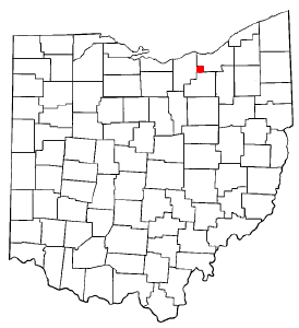
Cuyahoga County is a large urban county located in the northeastern part of the U.S. state of Ohio. It is situated on the southern shore of Lake Erie, across the U.S.-Canada maritime border. As of the 2020 census, its population was 1,264,817, making it the second-most-populous county in the state.

<span class="mw-page-title-main">Fairview Park, Ohio</span> City in Ohio, United States

Fairview Park is a city in Cuyahoga County, Ohio, United States. A suburb of Cleveland, it once formed part of the historical Rockport Township, along with the area of West Park and the suburbs of Lakewood and Rocky River. It borders Cleveland to the east, Westlake and North Olmsted to the west, Rocky River and Lakewood to the north and Brook Park to the south. At the 2010 census, the city population was 16,826.

<span class="mw-page-title-main">Lakewood, Ohio</span> City in Ohio, United States

Lakewood is a city in Cuyahoga County, Ohio, United States, on the southern shore of Lake Erie. Established in 1889, it is one of Cleveland's historical streetcar suburbs and part of the Cleveland metropolitan area. The population was 50,942 at the 2020 census, making it the third largest city in Cuyahoga County, behind Cleveland and Parma.

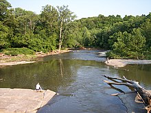
Tinker's Creek, in Cuyahoga, Summit and Portage counties, is the largest tributary of the Cuyahoga River, providing about a third of its flow into Lake Erie.

<span class="mw-page-title-main">Cleveland Metroparks</span> Public park system in Greater Cleveland, Ohio

Cleveland Metroparks is an extensive system of nature preserves in Greater Cleveland, Ohio. Eighteen reservations, which largely encircle the city of Cleveland, follow along the shore of Lake Erie and the rivers and creeks that flow through the region. Referred to unofficially as the 'Emerald Necklace', the network of parks spans over 24,000 acres (9,700 ha) and includes over 300 miles (480 km) of walking, bicycle, and horse trails as well as numerous picnic areas, nature education centers, golf courses, and countless fishing spots. In addition, the district includes the zoo in Cleveland. Four of the reservations are adjacent to Cuyahoga Valley National Park.

The Cleveland Memorial Shoreway, often shortened to "the Shoreway", is a limited-access freeway in Cleveland and Bratenahl, Ohio. It closely follows the shore of Lake Erie and connects the east and west sides of Cleveland via the Main Avenue Bridge over the Cuyahoga River. The entire length of the Shoreway is part of the Lake Erie Circle Tour (LECT) and all but the very eastern end of the Shoreway is part of State Route 2. The Shoreway also carries parts of Interstate 90 and State Route 283 on its eastern side, and parts of U.S. Route 6 and U.S. Route 20 on its western side. The Cleveland neighborhood of Detroit-Shoreway is named after the two roads that form the northern border, the Shoreway and Detroit Avenue.

<span class="mw-page-title-main">Chagrin River</span> River in Ohio, United States

The Chagrin River is located in Northeast Ohio. The river has two branches, the Aurora Branch and East Branch. Of three hypotheses as to the origin of the name, the most probable is that it is a corruption of the name of a Frenchman, Sieur de Seguin, who established a trading post on the river ca. 1742. The Chagrin River runs through suburban areas of Greater Cleveland in Cuyahoga, Geauga, and Portage counties, transects two Cleveland Metroparks reservations, and then meanders into nearby Lake County before emptying into Lake Erie.

Sun Newspapers was formed as a chain of weekly newspapers serving Northeast Ohio. Prior to a major reorganization in 2013, the chain consisted of 11 weekly newspapers serving 49 different communities in Greater Cleveland. The papers are focused on suburbs and exurbs in Cuyahoga, Geauga, Lorain and Medina counties. Its offices are in Valley View.

<span class="mw-page-title-main">Kamm's Corners</span> Neighborhood of Cleveland, Ohio, United States

Kamm's Corners is a neighborhood on the West Side of Cleveland, Ohio. It is bounded by the streetcar suburb of Lakewood to the north, the Rocky River Reservation of the Cleveland Metroparks and the suburbs of Rocky River and Fairview Park to the west, the New York Central Railroad tracks to the east, and Puritas Road to the south. Kamm's Corners Plaza and Warren Village are the major retail centers of the neighborhood. According to the 2019 U.S. census estimate, the neighborhood has the highest concentration of Irish Americans in Cleveland and Cuyahoga County.

<span class="mw-page-title-main">Columbia Township, Lorain County, Ohio</span> Township in Ohio, United States

Columbia Township, also known as Columbia Station or just Columbia, is the easternmost of the eighteen townships of Lorain County, Ohio, United States. Columbia Township is the official government name, while Columbia Station is the post office name, and tends to be the town name used by residents. The post office name was chosen to differentiate the township from other Columbia Townships statewide, located in Hamilton and Meigs counties.

<span class="mw-page-title-main">Olmsted Township, Cuyahoga County, Ohio</span> Township in Ohio, United States

Olmsted Township is a township located in Cuyahoga County, Ohio, United States. Situated in the southwest end of the county, Olmsted Township is a west side suburb of Cleveland, and a part of the even larger Greater Cleveland area. As of the 2010 Census, Olmsted had a population of 13,513. It is one of only two civil townships remaining in Cuyahoga County, and the only Olmsted Township statewide.

<span class="mw-page-title-main">Defunct townships of Cuyahoga County, Ohio</span>

Cuyahoga County, Ohio, United States is divided into 21 townships.

<span class="mw-page-title-main">Brooklyn Centre</span> Neighborhood of Cleveland, Ohio, United States

Brooklyn Centre is a neighborhood on the West Side of Cleveland, Ohio. It borders Old Brooklyn to the south, Stockyards, Clark–Fulton, and Tremont to the north, and the Cuyahoga Valley and the suburb of Cuyahoga Heights to the east.

<span class="mw-page-title-main">U.S. Route 6 in Ohio</span>

U.S. Route 6 is a part of the United States Numbered Highway System that runs from Bishop, California to Provincetown, Massachusetts. US 6 is the second longest federal highway in the United States, second only to U.S. Route 20. In Ohio, the road runs west-east from the Indiana state line near Edgerton to the Pennsylvania state line near Andover. The 248.002 miles (399.121 km) that lie in Ohio are maintained by the Ohio Department of Transportation (ODOT). US 6 serves the major cities of Sandusky, Lorain, and Cleveland. The highway is also called the Grand Army of the Republic Highway to honor the Union forces of the American Civil War. The alternate name was designated in 1953.

<span class="mw-page-title-main">West Park, Cleveland</span> Historical area of Cleveland, Ohio, United States

West Park is a historical area on the West Side of Cleveland, Ohio. Once an independent municipality, it was annexed by Cleveland after a referendum in 1923. The area covers 12.5 square miles and is bounded by West 117th Street to the east, the Rocky River Valley to the west, Brookpark Road to the South, and the streetcar suburb of Lakewood to the north. The Cleveland City Planning Commission traditionally divides West Park into four neighborhoods: Jefferson, Kamm's Corners, Bellaire–Puritas, and Hopkins.

This is a list of high school athletic conferences in the Northeast Region of Ohio, as defined by the OHSAA. Because the names of localities and their corresponding high schools do not always match and because there is often a possibility of ambiguity with respect to either the name of a locality or the name of a high school, the following table gives both in every case, with the locality name first, in plain type, and the high school name second in boldface type. The school's team nickname is given last.

The Great Lakes Conference is an OHSAA athletics conference that began play with the 2015-16 school year. The following are members:

<span class="mw-page-title-main">Cleveland Foundation Centennial Lake Link Trail</span>

The Cleveland Foundation Centennial Lake Link Trail, originally known as the Lake Link Trail, is a cycling, hiking, and walking trail located in the city of Cleveland, Ohio, in the United States. Owned by the city of Cleveland and maintained by Cleveland Metroparks, the trail runs along the former track bed of the Cleveland and Mahoning Valley Railroad. The trail is named for The Cleveland Foundation, a local community foundation which donated $5 million toward the trail's construction. The southern leg of the 1.3-mile (2.1 km) trail opened in August 2015, and the northern leg in August 2017. The middle leg will begin construction once the Irishtown Bend hillside is stabilized. A bridge connecting the trail to Whiskey Island will begin construction in Spring 2019 and will be completed in early Summer 2020.

<span class="mw-page-title-main">Euclid Creek</span> River in Ohio, United States

Euclid Creek is a 43-mile (69 km) long stream located in Cuyahoga and Lake counties in the state of Ohio in the United States. The 11.5-mile (18.5 km) long main branch runs from the Euclid Creek Reservation of the Cleveland Metroparks to Lake Erie. The west branch is usually considered part of the main branch, and extends another 16 miles (26 km) to the creek's headwaters in Beachwood, Ohio. The east branch runs for 19 miles (31 km) and has headwaters in Willoughby Hills, Ohio.

References

  1. 1 2 "Ohio State Route 2, see diagram on page 4 of 12" (PDF). Ohio Department of Transportation.
  2. "Straight Line Diagrams". Ohio Department of Transportation.