Cayuga Creek

Last updated
Cayuga Creek
Cayuga Creek.jpg
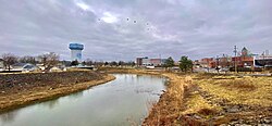
Cayuga Creek in Lancaster
USA New York relief location map.svg
Red pog.svg
Location of the mouth of Cayuga Creek in New York State.
Usa edcp relief location map.png
Red pog.svg
Cayuga Creek (the United States)
Location
CountryUnited States
State New York
RegionWestern New York
Physical characteristics
Source 
  locationWyoming County
  coordinates 42°42′48″N78°21′53″W / 42.71333°N 78.36472°W / 42.71333; -78.36472 [1]
Mouth Buffalo River
  location
Erie County
  coordinates
42°52′12″N78°47′10″W / 42.87000°N 78.78611°W / 42.87000; -78.78611 [1]
Discharge 
  locationLancaster, New York [2]

Cayuga Creek is a small stream in western New York, United States, with stretches in both Erie County and Wyoming County. [1] The creek enters Buffalo Creek in the northwest corner of the Town of West Seneca in Erie County, just upstream from the New York State Thruway crossing. At that point, Buffalo Creek becomes the Buffalo River and flows into Lake Erie near Buffalo, New York.

Contents

The creek is named after the Cayuga nation, one of the constituent members of the Iroquois Confederacy.

Cities and settlements

The watershed of Cayuga Creek includes the towns of Alden, Cheektowaga, Elma, Lancaster, and Marilla in Erie County and the towns of Bennington and Sheldon in Wyoming County. Village centers along Cayuga Creek include Lancaster and Depew.

A sewage treatment facility in the Town of Cheektowaga discharges into Cayuga Creek upstream of Borden Road. Downstream from Borden Road the creek runs along the Indian Road landfill.

Parks and history

Cayuga Creek runs through the Lancaster Country Club and Como Lake Park in the Town of Lancaster. The Lancaster Country Club diverts some creek water for golf course irrigation. [3] In Como Lake Park, the creek is dammed upstream of Lake Avenue. Farther downstream the creek is an important feature in Stiglmeier Park in the Town of Cheektowaga.

After Cayuga Creek flooded the Village of Lancaster twice in the early 1940s, [4] protective dikes were constructed.

See also

Related Research Articles

<span class="mw-page-title-main">Erie Canal</span> Waterway in New York, U.S.

The Erie Canal is a historic canal in upstate New York that runs east–west between the Hudson River and Lake Erie. Completed in 1825, the canal was the first navigable waterway connecting the Atlantic Ocean to the Great Lakes, vastly reducing the costs of transporting people and goods across the Appalachians. In effect, the canal accelerated the settlement of the Great Lakes region, the westward expansion of the United States, and the economic ascendancy of New York State. It has been called "The Nation's First Superhighway."

<span class="mw-page-title-main">Erie County, New York</span> County in New York, United States

Erie County is a county along the shore of Lake Erie in western New York State. As of the 2020 census, the population was 954,236. The county seat is Buffalo, which makes up about 28% of the county's population. Both the county and Lake Erie were named for the regional Iroquoian language-speaking Erie tribe of Native Americans, who lived in the area before 1654. They were later pushed out by the more powerful Iroquoian nations tribes.

<span class="mw-page-title-main">Depew, New York</span> Village in New York, United States

Depew is a village in Erie County, New York. The population was 15,303 at the time of the 2010 census. It is part of the Buffalo–Niagara Falls metropolitan area. The village is named for Chauncey Depew, a politician and one of the original investors who bought the land for the village, which was incorporated in 1894.

<span class="mw-page-title-main">Cheektowaga, New York</span> Town in New York, United States

Cheektowaga is a town in Erie County, New York, United States. As of the 2020 census, the town has grown to a population of 89,877. The town is in the north-central part of the county, and is an inner ring suburb of Buffalo. The town is the second-largest suburb of Buffalo, after the Town of Amherst.

<span class="mw-page-title-main">Lancaster (village), New York</span> Village in New York, United States

Lancaster is a village in Erie County, New York, United States. As of the 2010 census, the village population was 10,352. It is part of the Buffalo-Niagara Falls metropolitan area.

<span class="mw-page-title-main">Lancaster, New York</span> Town in New York, United States

Lancaster is a town in Erie County, New York, United States, centered 14 miles east of downtown Buffalo. Lancaster is an outer ring suburb of Buffalo. As of the 2020 Census, the town population was 45,106.

<span class="mw-page-title-main">West Seneca, New York</span> Town in New York, United States

West Seneca is a town in Erie County, New York, United States. The population was 45,500 at the 2020 census. West Seneca is a centrally located interior town of the county, and a suburb of Buffalo. West Seneca, Orchard Park and Hamburg form the inner "Southtowns", a cluster of middle-class suburban towns.

<span class="mw-page-title-main">Buffalo River (New York)</span> River in New York, United States

The Buffalo River drains a 447-square-mile (1,160 km2) watershed in Western New York state, emptying into the eastern end of Lake Erie at the City of Buffalo. The river has three tributaries: Cayuga Creek, Buffalo Creek, and Cazenovia Creek.

<span class="mw-page-title-main">Seneca River (New York)</span> River in Upstate New York

The Seneca River flows 61.6 miles (99.1 km) through the Finger Lakes region of Upstate New York in the United States. The main tributary of the Oswego River – the second-largest river flowing into Lake Ontario – the Seneca drains 3,468 square miles (8,980 km2) in parts of fourteen New York counties. The Seneca flows generally east, and is wide and deep with a gentle gradient. Much of the river has been channelized to form part of the Erie Canal.

<span class="mw-page-title-main">Ellicott Creek</span> River in New York, United States

Ellicott Creek is a stream in Western New York, United States. It is a tributary of Tonawanda Creek, which in turn flows into the Niagara River.

<span class="mw-page-title-main">New York State Route 78</span> State highway in western New York, US

New York State Route 78 (NY 78) is a 73.49-mile-long (118.27 km) state highway in western New York in the United States. While it is signed north–south, the southern portion runs in an east–west direction across Wyoming and Erie counties, from its beginning at a junction with NY 19 north of the village of Gainesville to the village of East Aurora. The part of the route north of East Aurora follows a generally north–south alignment to an intersection with NY 18 in the Niagara County town of Newfane, just south of the Lake Ontario shoreline. The route is most closely identified in the region with Transit Road, a major north–south trunk road through the center of Erie and Niagara counties; however, NY 78 does not follow Transit Road for its entire length, nor does Transit Road comprise more than half its length. The highway joins Transit Road north of East Aurora and stays with the road until nearly its end in the city of Lockport.

<span class="mw-page-title-main">New York State Route 277</span> State highway in Erie County, New York, US

New York State Route 277 (NY 277) is a state highway in New York in the United States. This highway is also called Union Road, along with other names. NY 277 is a major north–south road east of Buffalo, New York, through the middle of Erie County. The section of NY 277 north of Orchard Park used to be New York State Route 18B until the portion of NY 18 south of Niagara Falls was deleted on January 1, 1962.

<span class="mw-page-title-main">New York State Route 130</span> State highway in Erie County, New York, US

New York State Route 130 (NY 130) is a state highway entirely within Erie County, New York, in the United States. It runs east–west from U.S. Route 62 in Buffalo to the village of Depew, where it terminates at US 20 and NY 78. Throughout this course, NY 130 is named Broadway, a roadway name that continues eastward beyond Depew even after NY 130 ends.

<span class="mw-page-title-main">New York State Route 240</span> State highway in western New York, US

New York State Route 240 (NY 240) is a 51.64-mile (83.11 km) state highway in western New York in the United States. The southern terminus of the route is at an intersection with NY 242 in the Ellicottville community of Ashford Junction in northern Cattaraugus County. Its northern terminus is at a junction with NY 324 and Interstate 290 (I-290) in Amherst in northern Erie County. The route passes through the villages of Springville and Orchard Park, where it meets NY 39 and U.S. Route 20A (US 20A), respectively. Much of NY 240 between Concord and Aurora follows the west branch of Cazenovia Creek. The northern part of NY 240 in Erie County, named Harlem Road, is a major north–south route through the suburbs east of the city of Buffalo.

<span class="mw-page-title-main">Scajaquada Creek</span> River in New York, United States

Scajaquada Creek is a stream in Erie County, New York, United States. The name is derived from Philip Kenjockety, a Native American described as the oldest resident of the region upon his death in 1808.

<span class="mw-page-title-main">Eighteen Mile Creek (Erie County)</span> River in New York, United States

Eighteen Mile Creek is a tributary of Lake Erie located in southern Erie County, New York, United States. The creek is the second largest tributary of Lake Erie in New York State.

Bowmansville is a hamlet located in the town of Lancaster in Erie County, New York, United States. It is named after Benjamin Bowman, the owner of sawmills on Ellicott Creek in the center of the hamlet.

<span class="mw-page-title-main">Chadakoin River</span> River in New York, United States

The Chadakoin River is a 7.8-mile-long (12.6 km) stream that is a tributary of the Conewango Creek. The Chadakoin lies entirely in Chautauqua County in Western New York in the United States.

<span class="mw-page-title-main">Como Lake Park</span> Park in Erie County, New York, US

Como Lake Park is a 534-acre (2.16 km2) park in Erie County, in the U.S. state of New York. The park is located along the banks of Cayuga Creek in both the village and town of Lancaster, approximately 14 miles (23 km) east of the city of Buffalo. It is operated by the Erie County Department of Parks, Recreation and Forestry. Access is free and it is open to the public year-round.

<span class="mw-page-title-main">Transportation in Buffalo, New York</span>

Transportation in Buffalo, New York is dominated by automobile use, but other modes of transportation exist in the city.

References

  1. 1 2 3 "Cayuga Creek". Geographic Names Information System . United States Geological Survey, United States Department of the Interior . Retrieved March 8, 2015.
  2. "04215000 Cayuga Creek near Lancaster, NY" (PDF). National Water Information System. U.S. Geological Survey. 1993–2013. Retrieved April 4, 2015.
  3. "USGS 04215000 CAYUGA CREEK NR LANCASTER NY". National Water Information System. U.S. Geological Survey . Retrieved March 8, 2015.
  4. "Cayuga Creek at Lancaster". Advanced Hydrologic Prediction Service. National Weather Service . Retrieved March 8, 2015.